geo.wikisort.org - River
Hudson Branch is a 9.36 mi (15.06 km) long 2nd order tributary to Spring Creek in Kent County, Delaware.
| Hudson Branch Tributary to Spring Creek | |
|---|---|
 Location of Hudson Branch mouth  Hudson Branch (Spring Creek tributary) (the United States) | |
| Location | |
| Country | United States |
| State | Delaware |
| County | Kent |
| Physical characteristics | |
| Source | Cow Marsh Ditch divide |
| • location | about 0.5 miles southwest of Riverdale Estates, Delaware |
| • coordinates | 39°00′11″N 075°37′32″W[1] |
| • elevation | 60 ft (18 m)[2] |
| Mouth | Spring Creek |
• location | about 2.5 miles northwest of Frederica, Delaware |
• coordinates | 39°01′44″N 075°30′00″W[1] |
• elevation | 0 ft (0 m)[2] |
| Length | 9.36 mi (15.06 km)[3] |
| Basin size | 8.90 square miles (23.1 km2)[4] |
| Discharge | |
| • location | Spring Creek |
| • average | 10.78 cu ft/s (0.305 m3/s) at mouth with Spring Creek[4] |
| Basin features | |
| Progression | Spring Creek → Murderkill River → Delaware Bay → Atlantic Ocean |
| River system | Murderkill River |
| Tributaries | |
| • left | unnamed tributaries |
| • right | unnamed tributaries |
| Waterbodies | McGinnis Pond |
| Bridges | Firetower Road, Turkey Point Road, US 13, DE 15, Barratts Chapel Road, Fox Chase Road, McGinnis Pond Road |
Variant names
According to the Geographic Names Information System, it has also been known historically as:[1]
- Berrytown Branch
- Canterbury Branch
- Cranberry Branch
- Hudson Ditch
- Hudson's Branch
Course
Hudson Branch rises on the Cow Marsh Ditch divide about 0.5 miles southwest of Riverdale Estates, Delaware. Hudson Branch then flows easterly to meet Spring Creek about 2.5 miles northwest of Frederica, Delaware.[2]
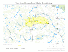
Watershed
Hudson Branch drains 8.90 square miles (23.1 km2) of area, receives about 44.9 in/year of precipitation, has a topographic wetness index of 597.91 and is about 6.0% forested.[4]
See also
- List of Delaware rivers
Maps

References
- "GNIS Detail - Hudson Branch". geonames.usgs.gov. US Geological Survey. Retrieved 12 March 2020.
- "Hudson Branch Topo Map, Kent County DE (Frederica Area)". TopoZone. Locality, LLC. Retrieved 12 March 2020.
- "ArcGIS Web Application". epa.maps.arcgis.com. US EPA. Retrieved 12 March 2020.
- "Hudson Branch Watershed Report". Waters Geoviewer. US EPA. Retrieved 12 March 2020.
State of Delaware | |
|---|---|
Dover (capital) | |
| Topics |
|
| Society |
|
| Cities | |
| Towns |
|
| Counties | |
Текст в блоке "Читать" взят с сайта "Википедия" и доступен по лицензии Creative Commons Attribution-ShareAlike; в отдельных случаях могут действовать дополнительные условия.
Другой контент может иметь иную лицензию. Перед использованием материалов сайта WikiSort.org внимательно изучите правила лицензирования конкретных элементов наполнения сайта.
Другой контент может иметь иную лицензию. Перед использованием материалов сайта WikiSort.org внимательно изучите правила лицензирования конкретных элементов наполнения сайта.
2019-2026
WikiSort.org - проект по пересортировке и дополнению контента Википедии
WikiSort.org - проект по пересортировке и дополнению контента Википедии