geo.wikisort.org - River
The Gurglbach is a river of Tyrol, Austria.
| Gurglbach | |
|---|---|
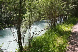 Gurglbach in Karrösten | |
| Location | |
| Country | Austria |
| State | Tyrol |
| Physical characteristics | |
| Source | |
| • location | Heiterwand |
| Mouth | |
• location | Inn |
• coordinates | 47.2183°N 10.7550°E |
| Length | 25.2 km (15.7 mi) [1] |
| Basin features | |
| Progression | Inn→ Danube→ Black Sea |
The Gurglbach originates on the rock face Heiterwand near Nassereith. It flows from west to east to Tarrenz, the only village that it passes completely through. There, it changes its route and flows south to Imst where it merges with the river Inn 4 km (2.5 mi) away from the town. It has a length of 25.2 km (15.7 mi).[1]
The river is one of the cleanest waters of Tyrol.[citation needed] It is a calm, slow running brook.[citation needed]
References
| Authority control |
|
|---|
This Tyrol location article is a stub. You can help Wikipedia by expanding it. |
На других языках
[de] Gurglbach
Der Gurglbach, im Unterlauf Pigerbach, ist ein linker Zufluss des Inns im Bezirk Imst in Tirol, Österreich.- [en] Gurglbach
Текст в блоке "Читать" взят с сайта "Википедия" и доступен по лицензии Creative Commons Attribution-ShareAlike; в отдельных случаях могут действовать дополнительные условия.
Другой контент может иметь иную лицензию. Перед использованием материалов сайта WikiSort.org внимательно изучите правила лицензирования конкретных элементов наполнения сайта.
Другой контент может иметь иную лицензию. Перед использованием материалов сайта WikiSort.org внимательно изучите правила лицензирования конкретных элементов наполнения сайта.
2019-2026
WikiSort.org - проект по пересортировке и дополнению контента Википедии
WikiSort.org - проект по пересортировке и дополнению контента Википедии