geo.wikisort.org - River
Glonn is a river in Bavaria, Germany.
| Glonn | |
|---|---|
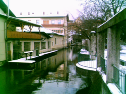 The Glonn in Bad Aibling | |
| Location | |
| Country | Germany |
| State | Bavaria |
| Physical characteristics | |
| Mouth | |
• location | Mangfall |
• coordinates | 47.8536°N 12.0170°E |
| Length | 28.7 km (17.8 mi) [1] |
| Basin size | 145 km2 (56 sq mi) [1] |
| Basin features | |
| Progression | Mangfall→ Inn→ Danube→ Black Sea |
Its source is in Glonn in the Ebersberg district and it flows in the south-east direction via Beyharting (Tuntenhausen) to Bad Aibling, where it flows into the Mangfall.
The Glonn has a length of about 29 km (18 mi). Its name originates from "Glana", "the clear one" (female) in Celtic languages.
See also
- List of rivers in Bavaria
References
- Complete table of the Bavarian Waterbody Register by the Bavarian State Office for the Environment (xls, 10.3 MB)
External links
 Media related to Glonn (Mangfall) at Wikimedia Commons
| Authority control |
|
|---|
На других языках
[de] Glonn (Mangfall)
Die Glonn (keltisch: Glana – „die Klare“) ist ein Fluss in Oberbayern. Sie entspringt in Ursprung bei Glonn im Landkreis Ebersberg und fließt in Richtung Südosten über Beyharting (Gemeinde Tuntenhausen) nach Bad Aibling, wo sie in die Mangfall mündet. Die Glonn ist etwa 26 km lang.- [en] Glonn (Mangfall)
Текст в блоке "Читать" взят с сайта "Википедия" и доступен по лицензии Creative Commons Attribution-ShareAlike; в отдельных случаях могут действовать дополнительные условия.
Другой контент может иметь иную лицензию. Перед использованием материалов сайта WikiSort.org внимательно изучите правила лицензирования конкретных элементов наполнения сайта.
Другой контент может иметь иную лицензию. Перед использованием материалов сайта WikiSort.org внимательно изучите правила лицензирования конкретных элементов наполнения сайта.
2019-2026
WikiSort.org - проект по пересортировке и дополнению контента Википедии
WikiSort.org - проект по пересортировке и дополнению контента Википедии