geo.wikisort.org - River
The Gardon or Gard (Occitan and French: Gardon, Gard, French pronunciation: [ɡaʁdɔ̃] (![]() listen), [ɡaʁ] (
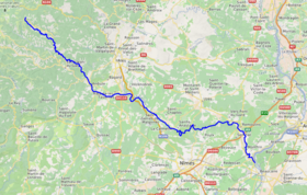
listen), [ɡaʁ] (![]() listen)) is a river in southern France. It is the namesake of the department of Gard. Several of its tributaries are also called Gardon. It is 127.6 km (79.3 mi) long, and takes its source in the commune of Saint-Martin-de-Lansuscle, in the Cévennes mountain range.[1] In its upper course it is also referred to as Gardon de Saint-Martin. From its furthest source, that of its tributary "Gardon de Saint-Jean", it is 133 km long. It flows into the Rhône (right-side tributary) at Comps, north of Beaucaire, across from Vallabrègues.
listen)) is a river in southern France. It is the namesake of the department of Gard. Several of its tributaries are also called Gardon. It is 127.6 km (79.3 mi) long, and takes its source in the commune of Saint-Martin-de-Lansuscle, in the Cévennes mountain range.[1] In its upper course it is also referred to as Gardon de Saint-Martin. From its furthest source, that of its tributary "Gardon de Saint-Jean", it is 133 km long. It flows into the Rhône (right-side tributary) at Comps, north of Beaucaire, across from Vallabrègues.
| Gardon | |
|---|---|
 The Gardon near the Pont du Gard | |
 | |
| Location | |
| Country | France |
| Physical characteristics | |
| Source | |
| • location | Cévennes |
| Mouth | Rhône |
• coordinates | 43°51′6″N 4°36′54″E |
| Length | 133 km (83 mi) |
| Basin size | 2,200 km2 (850 sq mi) |
| Discharge | |
| • average | 32 m3/s (1,100 cu ft/s) |
| Basin features | |
| Progression | Rhône→ Mediterranean Sea |
| Tributaries | |
| • left | Gardon d'Alès |


Features
The Roman aqueduct Pont du Gard and the 16th-century Pont Saint-Nicolas are two historic bridges that cross the Gardon. The Gorges du Gardon, which ends at Pont Saint-Nicolas, is a popular recreation area for kayaking, canoeing, rock climbing, and hiking.
The village of Collias, approximately 12 kilometres (7 mi) downriver from the Pont Saint-Nicolas, has several kayak and canoe rental agencies which will bus customers upriver to the Pont Saint-Nicolas (until the river level drops low in late June). Departing from Collias by kayak or canoe will bring you to the Pont du Gard in about an hour and one-half. It is possible to kayak or canoe under the Pont du Gard. Though, at times, the river is not high enough to allow for passage.
Floods
In September 2002 and again in December 2003, the Gardon had record level floods that damaged many of its bridges including the Pont Saint-Nicolas, which has since been fully restored. The river today shows few signs of the floods.
Places along the river
- Lozère
- Gard : Anduze, Saint-Jean-du-Gard, Saint-André-de-Valborgne, Remoulins, Montfrin
La Grand-Combe and Alès are situated on the Gardon d'Alès, the major left tributary.
References
External links
- Regordane Info - The independent portal for the Regordane Way or St Gilles Trail. The Regordane Way runs alongside the river Gardon from Ners south-eastwards (in English and French)
Authority control | |
|---|---|
| General |
|
| National libraries | |
| Other |
|
На других языках
[de] Gardon
Der Gardon (im Unterlauf auch gleichberechtigt Gard genannt) ist ein Fluss in der französischen Region Okzitanien, der in den Cevennen entspringt und in die Rhône mündet. Schon in der Antike war er unter dem Namen Vardo bekannt.- [en] Gardon
[es] Río Gardon
El río Gardon, (también llamado Gard, ambos nombre se usan tanto en francés como en occitano) es un río de Francia que fluye por la región Occitania y desemboca en el río Ródano cerca de Beaucaire (departamento de Gard). Nace en los montes Cévennes, en el departamento de Lozère. Procede de la unión del Gardon d’Alès y el Gardon d’Anduze, por lo que los habitantes de ambos valles consideran al suyo el auténtico Gard. Su longitud es de 127,40km. Su cuenca tiene unos 2200km² de superficie.[it] Gardon (fiume)
Il Gardon (o Gard) è un fiume che scorre nel sud della Francia. Il dipartimento francese del Gard (30) ne prende il nome. La sua lunghezza è di 133 km,[1] nasce dalla catena montuosa delle Cévennes e confluisce nel fiume Rodano (affluente di destra) all'altezza di Beaucaire, sulla riva opposta di Vallabrègues.[ru] Гардон (река)
Гардо́н (также Гар или Гард) — река на юге Франции. Департамент Гар получил своё название от этой реки.Другой контент может иметь иную лицензию. Перед использованием материалов сайта WikiSort.org внимательно изучите правила лицензирования конкретных элементов наполнения сайта.
WikiSort.org - проект по пересортировке и дополнению контента Википедии