geo.wikisort.org - River
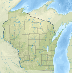
The Flag River is a river that flows through Bayfield County, Wisconsin.[2] The source of the river is in the Town of Port Wing within the Moquah Barrens Research Natural Area. The river then flows through the Town of Orienta and back into the Town of Port Wing. From there, it goes past the census-designated place of Port Wing and empties into Lake Superior.[3]
| Flag River Spencers River | |
|---|---|
  | |
| Location | |
| Country | United States |
| State | Wisconsin |
| Physical characteristics | |
| Source | |
| • location | Town of Port Wing |
| • coordinates | 46.6904932°N 91.2799098°W |
| Mouth | Lake Superior |
• location | CDP of Port Wing |
• coordinates | 46.7896571°N 91.3893515°W |
• elevation | 604 ft (184 m) |
| Basin features | |
| Tributaries | |
| • right | East Fork Flag River[1] |
The Flag River State Wildlife Area is directly east of the river.[4]
See also
References
- "East Fork Flag River". USGNIS. U.S. Department of the Interior. Retrieved 29 November 2020.
- "Flag River". USGNIS. U.S. Department of the Interior. Retrieved 29 November 2020.
- "Bayfield County" (PDF). Wisconsin DNR. Retrieved 29 November 2020.
- "Flag River State Wildlife Area". stateparks.com. Retrieved 29 November 2020.
Текст в блоке "Читать" взят с сайта "Википедия" и доступен по лицензии Creative Commons Attribution-ShareAlike; в отдельных случаях могут действовать дополнительные условия.
Другой контент может иметь иную лицензию. Перед использованием материалов сайта WikiSort.org внимательно изучите правила лицензирования конкретных элементов наполнения сайта.
Другой контент может иметь иную лицензию. Перед использованием материалов сайта WikiSort.org внимательно изучите правила лицензирования конкретных элементов наполнения сайта.
2019-2026
WikiSort.org - проект по пересортировке и дополнению контента Википедии
WikiSort.org - проект по пересортировке и дополнению контента Википедии