geo.wikisort.org - River
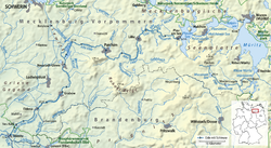
The Elde (German pronunciation: [ˈɛldə]) is a river in northern Germany (Mecklenburg-Vorpommern and a few km in Brandenburg), a right tributary of the Elbe. Its total length is 220 kilometres (140 mi). The Elde originates near Altenhof, south of Malchow. It first flows southeast towards the southern end of Lake Müritz, which it enters at Vipperow. It flows out of the Müritz at its northern end, near Waren. It turns west, and flows through a series of small lakes, and along the town of Malchow, until the Plauer See. It flows out of the Plauer See at Plau am See, and continues west and southwest through Lübz, Parchim, Neustadt-Glewe, Grabow and Eldena, and flows into the Elbe at Dömitz. Near Eldena, the Alte Elde branches off and flows into the Löcknitz (another tributary of the Elbe) near Eldenburg, part of Lenzen (Elbe). For much of its length, 180 kilometres (110 mi), it forms the navigable Müritz-Elde-Wasserstraße, with 17 locks.[1] The Elde is murky, due to the fast erosion of the valley around it.
| Elde | |
|---|---|
 | |
| Location | |
| Country | Germany |
| Physical characteristics | |
| Source | |
| • location | Mecklenburg-Vorpommern |
| Mouth | |
• location | Elbe |
• coordinates | 53.1357°N 11.2504°E |
| Length | 220 km (140 mi) |
| Basin features | |
| Progression | Elbe→ North Sea |
References
- Datentabellen, Generaldirektion Wasserstraßen und Schifffahrt Standort Magdeburg
| Authority control |
|
|---|
На других языках
[de] Elde
Die Elde ist der längste Fluss in Mecklenburg-Vorpommern,[2] liegt im Süden und Südwesten dieses Landes und verbindet das Gebiet um die Müritz mit der Elbe. Sie durchfließt in ihrem Oberlauf mehrere große Seen der Mecklenburgischen Seenplatte. Der letzte dieser Seen ist der Plauer See, ab dem der Fluss staugeregelt ist. 180 Kilometer der insgesamt 208 Kilometer[3] langen Elde vom Südrand der Müritz bis zur Elbe bei Dömitz sind schiffbar. Sie bilden die als Bundeswasserstraße ausgewiesene Müritz-Elde-Wasserstraße.[4]- [en] Elde
[it] Elde (fiume)
La Elde, con i suoi 208 km di lunghezza è il fiume più lungo del Land del Meclemburgo-Pomerania Anteriore.[1] Esso scorre nel sud e nel sudovest dello stato e collega la zona del lago Müritz con l'Elba. Il suo tratto lungo 180 km,[2] navigabile ed ampiamente regolato da Dömitz fino all'estremo sud del Müritz è denominato Müritz-Elde-Wasserstraße ed è considerato una Bundeswasserstraße (Via d'acqua federale)[3] della quale è competente l'ufficio per la Navigazione e le Acque di Lauenburg.[ru] Эльде
Эльде (нем. Elde) — 208-километровая река в Германии, крупнейшая в земле Мекленбург-Передняя Померания[1]. Площадь водосборного бассейна — 2990 км².[источник не указан 1209 дней]Другой контент может иметь иную лицензию. Перед использованием материалов сайта WikiSort.org внимательно изучите правила лицензирования конкретных элементов наполнения сайта.
WikiSort.org - проект по пересортировке и дополнению контента Википедии