geo.wikisort.org - River
The East Fork Williams Fork is a tributary of the Williams Fork in north central Colorado in the United States. The river merges with the South Fork Williams Fork to form the Williams Fork.[2]
| East Fork Williams Fork[1] | |
|---|---|
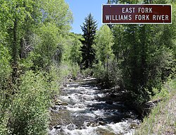
 The river just before it goes under County Road 8 in the Routt National Forest | |
| Physical characteristics | |
| Source | |
| • location | Devils Causeway |
| • coordinates | 40°02′27″N 107°09′50″W[1] |
| Mouth | |
• location | Confluence with South Fork Williams Fork |
• coordinates | 40°19′05″N 107°24′39″W[1] |
• elevation | 6,558 feet (1,999 meters)[1] |
| Basin features | |
| Progression | Williams Fork—Yampa—Green—Colorado |
| Tributaries | |
| • left |
|
| • right |
|
See also
References
- "East Fork Williams Fork". Geographic Names Information System. United States Geological Survey, United States Department of the Interior. Retrieved 2021-06-25.
- "Stream Trace Summary Report". USGS Streamer. United States Geological Survey. 2021-06-25. Retrieved 2021-06-25.
Текст в блоке "Читать" взят с сайта "Википедия" и доступен по лицензии Creative Commons Attribution-ShareAlike; в отдельных случаях могут действовать дополнительные условия.
Другой контент может иметь иную лицензию. Перед использованием материалов сайта WikiSort.org внимательно изучите правила лицензирования конкретных элементов наполнения сайта.
Другой контент может иметь иную лицензию. Перед использованием материалов сайта WikiSort.org внимательно изучите правила лицензирования конкретных элементов наполнения сайта.
2019-2025
WikiSort.org - проект по пересортировке и дополнению контента Википедии
WikiSort.org - проект по пересортировке и дополнению контента Википедии