geo.wikisort.org - River
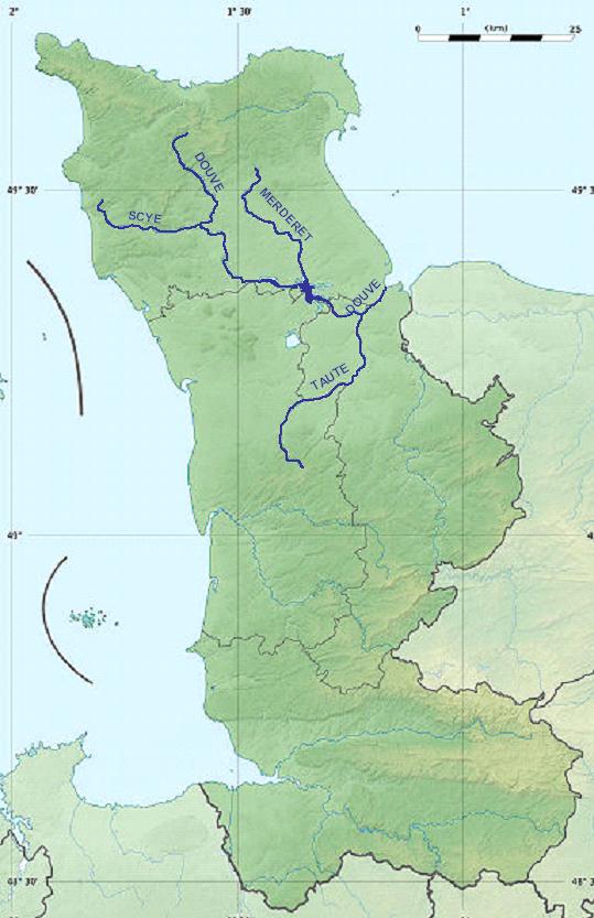
The Douve (French pronunciation: [duv]) or Ouve is a river, 78.6 km (48.8 mi) in length,[1] which rises in the commune of Tollevast, near Cherbourg in the department of Manche. Ouve is considered its old name (Unva in ancient texts): Ouve appears to have been misspelled over the course of time as "Douve river" and then as "River of the Douve" (Douve literally means Ditch). The French name for this watercourse is la Douve.
This article needs additional citations for verification. (August 2020) |
| Douve | |
|---|---|
 | |
 | |
| Location | |
| Country | France |
| Region | Normandy |
| Physical characteristics | |
| Source | |
| • location | Manche |
| Mouth | Bay of the Seine (English Channel) |
• coordinates | 49°21′32″N 1°10′10″W |
| Length | 79 km (49 mi) |
After passing Tollevast, the river proceeds through the hills of the Cotentin peninsula (Cherbourg peninsula) and goes by Sottevast, l'Étang-Bertrand and Magneville. It borders Néhou and crosses Saint-Sauveur-le-Vicomte. Once it reaches Bauptois, it alters its direction towards the Bay of the Seine in the south-eastern English Channel, passing through Carentan. The Douve is a navigable river owing to its flat bottom and adequate depth of flow.
In 1944 German troops, preparing Rommel's Fortress Europa, flooded the valley to prevent landing paratroops or gliders. On D-Day, the river was the boundary between the left flank of Allied landing forces on Utah Beach (on its left bank and so to the west nearest Rouen) and the bloody defensive battle that occurred at Omaha Beach. The Utah beach landings were part of contingency planning only scheduled after ample landing craft became available and designed to give the allies a leg up on taking a port city, in this case, Cherbourg, to bolster Allied logistical capacity. Had the landing craft been lacking, the river would have protected the exposed right flank of the allied invasion lodgement. With Utah in the plan, it was used to originate an offensive aimed squarely at the early domination of the peninsula and capture of Cherbourg and Caen (and eventually Rouen) at the opposite end of the lodgement. These cities were well protected by their German defenders.
Among those landing at the Douve was the unit known as the Filthy Thirteen, later the basis of the novel and film The Dirty Dozen.[2]
Hydrology
The Merderet is a tributary of the Douve.[1]
References
- Sandre. "Fiche cours d'eau - La Douve (I5--0200)".
- "John "Jack" Agnew dies at 88; his World War II unit inspired The Dirty Dozen". Los Angeles Times, April 13, 2010. Retrieved April 18, 2010.
Authority control | |
|---|---|
| General |
|
| Other |
|
На других языках
[de] Douve
Die Douve ist ein Küstenfluss in Frankreich, der im Département Manche, in der Region Normandie verläuft. Sie entspringt im Gemeindegebiet von Tollevast, entwässert generell in südöstlicher Richtung, durchquert den Regionalen Naturpark Marais du Cotentin et du Bessin und mündet nach rund 79[2] Kilometern nordöstlich von Carentan in den Ärmelkanal. Zwischen Carentan und der Mündung wurde der Fluss zum Canal de Carentan à la Mer ausgebaut, der auch von Schiffen befahren werden kann.- [en] Douve
[it] Douve
Il Douve è un piccolo fiume del nord della Francia, che nasce presso Cherbourg e sfocia nel Canale della Manica. Non è molto profondo, ma abbastanza da essere navigabile con imbarcazioni a fondo piatto.Другой контент может иметь иную лицензию. Перед использованием материалов сайта WikiSort.org внимательно изучите правила лицензирования конкретных элементов наполнения сайта.
WikiSort.org - проект по пересортировке и дополнению контента Википедии