geo.wikisort.org - River
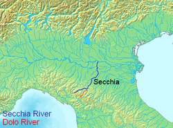
The Dolo is a mountain stream that rises on the slopes of Mount Cusna in the Reggio-Emilia province, of the Tuscany-Emilia Romagna Apennine Mountains. It is a tributary of the Secchia, and its length is about 21 to 26 kilometres (13 to 16 mi). The Dolo acts as a natural boundary between the provinces of Reggio Emilia and Modena.
| Dolo | |
|---|---|
 | |
| Location | |
| Country | Italy |
| Physical characteristics | |
| Source | |
| • location | Tuscan-Emilian Apennines, Mount Cusna |
| • coordinates | 44°14′24.21″N 10°27′22.31″E |
| • elevation | about 1,868 m (6,129 ft) |
| Mouth | |
• location | Secchia, North of Polinago |
• coordinates | 44°24′24.97″N 10°37′18.80″E |
| Length | 26 km (16 mi) |
| Basin features | |
| Progression | Secchia→ Po→ Adriatic Sea |
About 5 kilometres (3 mi) before entering the Secchia river, the Dragone mountain stream flows into the Dolo.
At the height of Fontanaluccia there is a dam (44°16′39.72″N 10°30′47.95″E) that provides water for a hydroelectric power plant (44°21′42.48″N 10°34′53.35″E) located 14 kilometres (9 mi) downstream in Farneta.
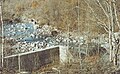 Dolo river near Romanoro
 Dolo river seen from the bridge crossing to the nearby village of Morsiano


Wikimedia Commons has media related to Dolo River.
На других языках
- [en] Dolo (river)
[it] Dolo (fiume)
Il Dolo è un torrente appenninico, affluente del fiume Secchia, che nasce in provincia di Reggio Emilia e segna per buona parte del suo percorso il confine tra le province e di Modena e Reggio.Текст в блоке "Читать" взят с сайта "Википедия" и доступен по лицензии Creative Commons Attribution-ShareAlike; в отдельных случаях могут действовать дополнительные условия.
Другой контент может иметь иную лицензию. Перед использованием материалов сайта WikiSort.org внимательно изучите правила лицензирования конкретных элементов наполнения сайта.
Другой контент может иметь иную лицензию. Перед использованием материалов сайта WikiSort.org внимательно изучите правила лицензирования конкретных элементов наполнения сайта.
2019-2026
WikiSort.org - проект по пересортировке и дополнению контента Википедии
WikiSort.org - проект по пересортировке и дополнению контента Википедии