geo.wikisort.org - River
The Coast Fork Willamette River is one of two forks that unite to form the Willamette River in western Oregon in the United States. It is about 40 miles (64 km) long, draining an area of the mountains at the south end of the Willamette Valley south of Eugene.
| Coast Fork Willamette River | |
|---|---|
 The Coast Fork Willamette River | |
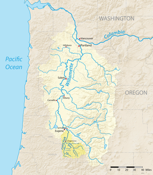 Map of the Willamette River basin with the Coast Fork highlighted | |
 Location of the mouth of the Coast Fork Willamette River in Oregon | |
| Etymology | Willamette is from a similar Clackamas Indian village name[1] |
| Location | |
| Country | United States |
| State | Oregon |
| County | Lane |
| Physical characteristics | |
| Source | Confluence of Big River and Garoutte Creek |
| • location | Calapooya Mountains, Oregon |
| • coordinates | 43°35′44″N 123°4′4″W[2] |
| • elevation | 990 ft (300 m)[3] |
| Mouth | Willamette River |
• location | near Eugene and Springfield, Oregon |
• coordinates | 44°1′23″N 123°1′25″W[2] |
• elevation | 436 ft (133 m)[2] |
| Length | 40 mi (64 km)[4] |
| Basin size | 666 sq mi (1,720 km2)[5] |
| Discharge | |
| • location | Goshen, 6.4 miles (10.3 km) from the mouth[6] |
| • average | 1,558 cu ft/s (44.1 m3/s)[7] |
| • minimum | 36 cu ft/s (1.0 m3/s) |
| • maximum | 58,500 cu ft/s (1,660 m3/s) |
| Basin features | |
| Tributaries | |
| • right | Row River |
Course
The Coast Fork Willamette River is formed in southwestern Lane County, in the Calapooya Mountains, by the confluence of the Little River and the Big River. The Coast Fork flows north through the mountains, through the Cottage Grove Lake reservoir, to Cottage Grove, where it receives the Row River from the southeast. It continues north past Creswell and joins the Middle Fork from the south, about 2 miles (3 km) southeast of Eugene, to form the Willamette.
See also
- List of rivers of Oregon
- Willamette Riverkeeper
References
- Bright, William (2004). Native American Placenames of the United States. Norman, Oklahoma: University of Oklahoma Press. p. 567. ISBN 978-0-8061-3598-4.
- "Coast Fork Willamette River". Geographic Names Information System (GNIS). United States Geological Survey. November 28, 1980. Retrieved August 4, 2010.
- Source elevation derived from Google Earth search using GNIS source coordinates.
- United States Geological Survey (USGS). "United States Geological Survey Topographic Map: Harness Mountain, Oregon, Quadrant". TopoQuest. Retrieved August 3, 2010. The map includes river-mile markers from mouth to source.
- "Coast Fork Willamette". Willamette Riverkeeper. Archived from the original on August 7, 2010. Retrieved August 4, 2010.
- "Water-data report 2009: 14157500 Coast Fork Willamette River near Goshen, OR" (pdf). United States Geological Survey. Retrieved April 22, 2011.
- "Water-data report 2009: 14157500 Coast Fork Willamette River near Goshen, OR" (pdf). United States Geological Survey. Retrieved April 22, 2011.
External links
 Media related to Coast Fork Willamette River at Wikimedia Commons
Текст в блоке "Читать" взят с сайта "Википедия" и доступен по лицензии Creative Commons Attribution-ShareAlike; в отдельных случаях могут действовать дополнительные условия.
Другой контент может иметь иную лицензию. Перед использованием материалов сайта WikiSort.org внимательно изучите правила лицензирования конкретных элементов наполнения сайта.
Другой контент может иметь иную лицензию. Перед использованием материалов сайта WikiSort.org внимательно изучите правила лицензирования конкретных элементов наполнения сайта.
2019-2026
WikiSort.org - проект по пересортировке и дополнению контента Википедии
WikiSort.org - проект по пересортировке и дополнению контента Википедии