geo.wikisort.org - River
The Cheremosh River (Ukrainian: Черемош, Romanian: Ceremuș, Polish: Czeremosz) is a river in western Ukraine, right-bank tributary of the river Prut.[1]
This article needs additional citations for verification. (December 2014) |
| Cheremosh | |
|---|---|
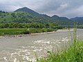
 Cheremosh in Vyzhnytsia Raion | |
| Location | |
| Country | Ukraine |
| Physical characteristics | |
| Mouth | |
• location | Prut at Nepolokivtsi |
• coordinates | 48.3789°N 25.6206°E |
| Length | 80 km (50 mi) |
| Basin features | |
| Progression | Prut→ Danube→ Black Sea |
| Tributaries | |
| • left | Chornyi Cheremosh |
| • right | Bilyi Cheremosh, Putylka |
Description
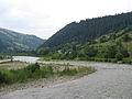
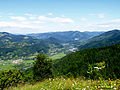
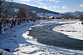
It is formed by confluence of two upper streams of the river Bilyi Cheremosh (White Cheremosh) and Chornyi Cheremosh (Black Cheremosh) near the village Usteriky (Verkhovyna Raion) and has a length of 80 km (50 mi).[1][2] Chornyi Cheremosh is 87 km long with a basin of 856 km2 and Bilyi Cheremosh is 61 km long with a basin of 606 km2.[1] The river starts in the Carpathian Mountains and flows roughly SW to NE. It leaves the Bukovina Obchinas (a mountain range in Outer Eastern Carpathians stretching in Ukraine and Romania) to the river's right, and the historic subregion of Pokuttya to the river's left side.
It flows along the borderline of the historic regions of Bukovina and Galicia.[1] In the Middle Ages and the early modern era, it was part of the borderline between the Principality of Moldavia and Kingdom of Poland.[1] Currently it runs along the borderline between the Ivano-Frankivsk and Chernivtsi Oblasts.
Both banks in the upper part of the river are inhabited by Hutsuls.
Rafting on Cheremosh river

It's hard to find another river on the territory of the former USSR that would be so popular and respectable among water tourists irrespective of its relatively small length. The tradition to hold sports rafting was initiated at the end of the 1950s and in 1967 near the village of Biloberizka and Petrashi the first all-Ukrainian competitions in water tourism on canoe. Since then the Cheremosh has become an avowed arena for holding national competitions, which actually turned into international events due to participation of crews from other countries. The traditions have not been lost up to now and the international popularity of the river grows with every passing year. Why is the Cheremosh so attractive? First, it attracts by unsurpassed beauty of the nature, diversity of the very water-way and the full complex of natural obstacles peculiar for mountain rivers ranging to the highest categories of complexity. The river is full of sudden turns, rapids, shivers (chaotic conglomeration of rocks in the river), floodgates, gorges, and whirlpools that do not allow the knights of oars and a life jacket to relax even for a single minute. The Cheremosh has two faces: mountainous and flat, consequently, after stormy scuffles and troubles in its head water you will feel the pleasure of quiet rest in its lower reaches. A very important advantage of the Cheremosh is the proximity of populated localities where you can stop for night in tourist camps or in private houses since the crucial element in any water trip is the issue of overnight stay under normal conditions: you cannot put too much equipment to a kayak or a canoe! Another important and favourable factor is the convenience of access roads and sufficiently long season of rafting — from early spring to late autumn.
Gallery

 Chornyi Cheremosh


External links
Towns in basin
- Verkhovyna
- Kuty
- Vyzhnytsya
- Vashkivtsi
See also
- Pokuttya
- Bukovina
- Cheremosh Ukrainian Dance Company, named for the river
References
- Cheremosh River at the Encyclopedia of Ukraine
- Evaluarea hidrologică a bazinului r. Prut, L. Chirică
Authority control | |
|---|---|
| General |
|
| National libraries | |
На других языках
[de] Tscheremosch
Der Tscheremosch (deutsch auch Czeremosch oder Czeremosz, ukrainisch Черемош; russisch Чере́мош, Черемошель; polnisch Czeremosz; rumänisch Ceremuş) ist ein rechter Nebenfluss des Pruth in der Westukraine in der Oblast Iwano-Frankiwsk und der Oblast Tscherniwzi.- [en] Cheremosh
[es] Río Cheremosh
El río Cheremosh (en ucraniano, Черемош; [en rumano, Ceremuş; en polaco, Czeremosz) es un corto río de Ucrania occidental, un afluente del río Prut. El río nace cerca de la localidad de Usteriky, de la confluencia de los ríos Czarny Cheremosh (Cheremosh Negro, de 87 km y una cuenca de 856 km²) y Biały Cheremosh (Blanco Cheremosh, de 80 km y 606 km²). El Cheremosh en sí tiene 80 km de largo y una cuenca hidrográfica de 2.560 km² (si se considera con el Czarny Cheremosh, tendría 165 km y 3.416 km²).[ru] Черемош
Черемо́ш (укр. Черемош, рум. Ceremuş) — река на Западной Украине, в Восточных Карпатах (Лесистые Карпаты), правый приток Прута (бассейн Дуная). Имеет длину 80 км, площадь бассейна составляет 2560 км². Это типичная горная река с быстрым течением скоростью от 8 до 20 км/час, с уклоном 3,3 м/км, общий перепад высот — 280 м.Другой контент может иметь иную лицензию. Перед использованием материалов сайта WikiSort.org внимательно изучите правила лицензирования конкретных элементов наполнения сайта.
WikiSort.org - проект по пересортировке и дополнению контента Википедии