geo.wikisort.org - River
Chaudière Falls (French: Chutes de la Chaudière) is a 35-meter-high (115 ft) waterfall in Lévis, Quebec along the Chaudière River. It is part of the regional Parc des Chutes-de-la-Chaudière, which features a 113-metre-long (371 ft) suspension footbridge standing 23 metres over the river.[3] There are walking and bicycle trails along the river.
This article may be expanded with text translated from the corresponding article in French. (February 2017) Click [show] for important translation instructions.
|
| Chaudière Falls | |
|---|---|
| French: Chutes de la Chaudière | |
 | |
| Location | Lévis, Quebec |
| Coordinates | 46°42′53″N 71°16′57″W[1] |
| Type | Segmented block |
| Total height | 35 metres (115 ft) |
| Total width | 240 m (790 ft) |
| Watercourse | Chaudière River |
| Average flow rate | 500 m3/s (18,000 cu ft/s)[2] |
Gallery
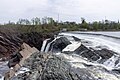 View from the top of the Chaudière Falls
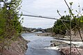 Footbridge on the Chaudière River
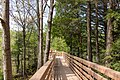 Walking trail in the park


See also
References
- Querying Geographical Names of Canada - Query by name Archived 2011-06-08 at the Wayback Machine
- "Graphique des données à une station hydrométrique". www.cehq.gouv.qc.ca. Retrieved 2020-11-04.
- "Parc des Chutes-de-la-Chaudière". Visitez Lévis. Retrieved 30 November 2016.
External links
 Media related to Chaudière Falls (Rivière Chaudière) at Wikimedia Commons
This waterfall-related article is a stub. You can help Wikipedia by expanding it. |
This Chaudière-Appalaches location article is a stub. You can help Wikipedia by expanding it. |
Текст в блоке "Читать" взят с сайта "Википедия" и доступен по лицензии Creative Commons Attribution-ShareAlike; в отдельных случаях могут действовать дополнительные условия.
Другой контент может иметь иную лицензию. Перед использованием материалов сайта WikiSort.org внимательно изучите правила лицензирования конкретных элементов наполнения сайта.
Другой контент может иметь иную лицензию. Перед использованием материалов сайта WikiSort.org внимательно изучите правила лицензирования конкретных элементов наполнения сайта.
2019-2025
WikiSort.org - проект по пересортировке и дополнению контента Википедии
WikiSort.org - проект по пересортировке и дополнению контента Википедии