geo.wikisort.org - River
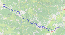
The Chassezac (French pronunciation: [ʃaszak]; Occitan: Chassesac) is an 84.6 km (52.6 mi) long river in the Lozère, Gard and Ardèche departments in southern France. It is a right tributary of the Ardèche.[1] Its source is in the commune of Saint-Frézal-d'Albuges, 2.8 km (1.7 mi) northeast of Les Chazeaux, the main hamlet in the commune. It flows generally southeast and flows into the Ardèche at Saint-Alban-Auriolles, 1.8 km (1.1 mi) east of the village itself.
This article may be expanded with text translated from the corresponding article in French. (January 2009) Click [show] for important translation instructions.
|
| Chassezac | |
|---|---|
 the Chassezac | |
 | |
| Location | |
| Country | France |
| Physical characteristics | |
| Source | |
| • location | in Saint-Frézal-d'Albuges |
| • coordinates | 44°35′30″N 03°46′47″E |
| • elevation | 1,350 m (4,430 ft) |
| Mouth | |
• location | Ardèche |
• coordinates | 44°25′39″N 04°19′12″E |
• elevation | 95 m (312 ft) |
| Length | 84.6 km (52.6 mi) |
| Basin size | 560 km2 (220 sq mi) |
| Discharge | |
| • average | 15.3 m3/s (540 cu ft/s) |
| Basin features | |
| Progression | Ardèche→ Rhône→ Mediterranean Sea |
Departments and communes it runs through
The following list is ordered from source to mouth :
- Lozère: Saint-Frézal-d'Albuges, Belvezet, Chasseradès, La Bastide-Puylaurent, Prévenchères, Pied-de-Borne
- Ardèche: Sainte-Marguerite-Lafigère,
- Gard: Malons-et-Elze
- Ardèche: Malarce-sur-la-Thines, Gravières, Les Salelles, Chambonas, Les Assions, Les Vans, Berrias-et-Casteljau, Chandolas, Beaulieu, Grospierres, Sampzon, Saint-Alban-Auriolles,
References
| Wikimedia Commons has media related to Chassezac. |
| Authority control |
|
|---|
This Lozère geographical article is a stub. You can help Wikipedia by expanding it. |
This Ardèche geographical article is a stub. You can help Wikipedia by expanding it. |
This Gard geographical article is a stub. You can help Wikipedia by expanding it. |
На других языках
[de] Chassezac
Der Chassezac ist ein Fluss in Frankreich, der in den Regionen Okzitanien und Auvergne-Rhône-Alpes verläuft. Sein Quellbach Ruisseau des Fourches entspringt in den Cevennen, an der West-Flanke des Moure de la Gardille (1503 m), im Gemeindegebiet von Saint-Frézal-d’Albuges. Er entwässert anfangs in südwestlicher Richtung, dreht dann auf Südost bis Ost, durchquert den südlichen Teil des Regionalen Naturparks Monts d’Ardèche und mündet nach rund 85[2] Kilometern an der Gemeindegrenze von Saint-Alban-Auriolles und Sampzon als rechter Nebenfluss in die Ardèche. Auf seinem Weg durchfließt der Chassezac die Départements Lozère und Ardèche. Auf wenigen Kilometern Länge bildet er auch die Grenze zum Département Gard.- [en] Chassezac
Другой контент может иметь иную лицензию. Перед использованием материалов сайта WikiSort.org внимательно изучите правила лицензирования конкретных элементов наполнения сайта.
WikiSort.org - проект по пересортировке и дополнению контента Википедии