geo.wikisort.org - River
The Charente (French: [ʃaʁɑ̃t] (![]() listen); Occitan: Charanta [tʃaˈɾantɔ]) is a 381-kilometre (237 mi) long river in southwestern France.[1]
Its source is in the Haute-Vienne département at Chéronnac, a small village near Rochechouart. It flows through the departments of Haute-Vienne, Charente, Vienne and Charente-Maritime. The river flows into the Atlantic Ocean near Rochefort.
listen); Occitan: Charanta [tʃaˈɾantɔ]) is a 381-kilometre (237 mi) long river in southwestern France.[1]
Its source is in the Haute-Vienne département at Chéronnac, a small village near Rochechouart. It flows through the departments of Haute-Vienne, Charente, Vienne and Charente-Maritime. The river flows into the Atlantic Ocean near Rochefort.
| Charente | |
|---|---|
 The Charente in Tonnay-Charente | |
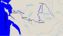 The Charente and its main tributaries | |
| Native name | Charanta (Occitan) |
| Location | |
| Country | France |
| Physical characteristics | |
| Source | |
| • location | Haute-Vienne |
| Mouth | |
• location | Atlantic Ocean |
• coordinates | 45°57′24″N 1°4′56″W |
| Length | 381 km (237 mi) |
| Basin size | 10,000 km2 (3,900 sq mi) |
| Discharge | |
| • average | 40 m3/s (1,400 cu ft/s) |
Navigation
The Charente was described by the French king François I as 'the most beautiful river in the kingdom', and was navigable in its natural state until mills were erected at many locations in the 14th century.[2] Some locks were built but through navigation remained impossible for centuries. Improvements to the navigation were projected under Louis XVI in 1772, but work was interrupted by the Revolution. The project was revived under the Restoration and canalisation completed in 1835. The waterway was abandoned in 1957. The départements took over operation in 1963, and recreational vessels have now taken possession of the waterway throughout the 164 km to the town of Angoulême.
The historic towns of Cognac, Jarnac, Saintes and Rochefort make the river a popular destination for boaters, mainly in rental boats, with moorings provided at most towns and villages along the route. The locks are 34.8 by 6.5 metres (114 by 21 ft).[3]
Tributaries
Tributaries include the rivers Antenne, Boëme, Né, Coran, Seugne, Bramerit, Boutonne, Arnoult, Touvre and Bonnieure.[1]
The river Boutonne is navigable over a distance of 31 km to Saint-Jean-d'Angély, but a barrier at the confluence prevents access except under exceptional conditions.
En route
Towns and villages include Vergeroux, Soubise, Rochefort and Tonnay-Charente on the tidal river, and Saint-Savinien, Taillebourg, Saintes, Cognac, Jarnac, Saint-Simon and Angoulême on the navigable river, while Montignac-Charente and Civray are on the river's upper course.
See also
- Kaolin deposits of the Charentes Basin
References
- Sandre. "Fiche cours d'eau - La Charente (R---0000)".
- Edwards-May, David (2010). Inland Waterways of France. St Ives, Cambs., UK: Imray Laurie Norie & Wilson Ltd. p. 67. ISBN 978-1-846230-14-1.
- Charente (amont et aval), Fluviacarte
External links
- River Charente and River Boutonne, with maps and details for navigation, by the author of Inland Waterways of France, referenced above
- Navigation details for 80 French rivers and canals (French waterways website section)
Authority control | |
|---|---|
| National libraries | |
| Other | |
На других языках
[de] Charente (Fluss)
Die Charente ist ein Fluss im Westen Frankreichs, der in der Region Nouvelle-Aquitaine verläuft. Sie entspringt im Gemeindegebiet von Chéronnac. Zunächst entwässert sie nach Nordwesten, dreht bei Civray in südlicher Richtung und erreicht schließlich Angoulême. Dort wendet sie sich nach Westen und fließt an Jarnac und Cognac vorbei, etwa bis Saintes. Zuletzt strömt sie nach Nordwesten und mündet unterhalb von Rochefort am Golf von Biskaya in den Atlantischen Ozean. Die Mündung befindet sich gegenüber der Île d’Oléron. Der Fluss ist rund 381 Kilometer lang und von der Mündung bis Angoulême auf einer Länge von etwa 150 Kilometern mit Schiffen befahrbar. Unterhalb von Saint-Savinien ist er bereits von den Gezeiten beeinflusst und bildet einen Mündungstrichter. Die Charente war einst ein wichtiger Transportweg für den berühmten französischen Weinbrand, der nach seiner Herkunft als Cognac bezeichnet wird. Heute wird der Fluss überwiegend von Touristen mit Sport- und Hausbooten genutzt.- [en] Charente (river)
[es] Río Charente
El Charente es un río de 381 km de largo en el suroeste de Francia. Su fuente está en el departamento de Alto Vienne, en Chéronnac, un pequeño pueblo cerca de Rochechouart. Fluye por los departamentos de Haute-Vienne, Charente, Vienne y Charente Marítimo. El río desemboca en el océano Atlántico cerca de Rochefort.[it] Charente (fiume)
La Charente è un fiume della Francia centro-occidentale, nella regione della Nuova Aquitania. Essa dà il nome anche ai dipartimenti della Charente e Charente Marittima (fino al 1941 Charente Inférieure).[ru] Шаранта (река)
Шаранта (фр. Charente) — река на юго-западе Франции. Исток расположен в западной части Центрального массива; протекает по северному краю Гароннской низменности[1], через департаменты Верхняя Вьенна, Вьенна, Шаранта и Приморская Шаранта. При впадении в Бискайский залив Атлантического океана (близ морского порта Рошфор) образует эстуарий длиной порядка 15 км[1]. Крупнейшие притоки — Ом (фр. Aume), Сон-Соннет (фр. Son-Sonnette), Тардуар (фр. Tardoire), Тувр (фр. Touvre), Нэ (фр. Né), Сёнь (фр. Seugne), Антан (фр. Antenne), Бутон (фр. Boutonne), Арну (фр. Arnoult).Другой контент может иметь иную лицензию. Перед использованием материалов сайта WikiSort.org внимательно изучите правила лицензирования конкретных элементов наполнения сайта.
WikiSort.org - проект по пересортировке и дополнению контента Википедии