geo.wikisort.org - River
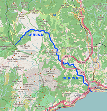
The Cerusa is a 10.7-kilometre (6.6 mi) stream of Liguria (Italy).
| Cerusa | |
|---|---|
 | |
 | |
| Location | |
| Country | Italy |
| Physical characteristics | |
| Source | |
| • location | Ligurian Apennines |
| • elevation | 376 m (1,234 ft) |
| Mouth | Ligurian Sea |
• location | Voltri (GE) |
• coordinates | 44°25′36″N 8°44′34″E |
• elevation | 0 m (0 ft) |
| Length | 10.7 km (6.6 mi)[1] |
| Basin size | 24 km2 (9.3 sq mi)[1] |
Geography

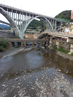
The river is formed at 376 m by the confluence of two streams, Rio Gava and Rio delle Cave,[2] in the Ligurian Apennines. The river then flows through the Valle Cerusa and crosses the villages of Fiorino, Fabbriche di Voltri e Fullo. Heading south reaches Voltri and ends its course in the Ligurian Sea, after being crossed by Autostrada A10, Genoa–Ventimiglia railway and Aurelia national road.
Cerusa basin (24 km2) is totally included in the Province of Genova.[3]
Main tributaries
- Left hand:
- Rio delle Cave.
- Right hand:
- Rio Gava;
- Rio Secco.
History
The Département de la Ceruse or Dipartimento della Cerusa of Ligurian Republic took its name at the end of the 18th century from the stream.[4]
References
- Ufficio Pianificazione territoriale (2013). AMBITI REGIONALI DI BACINO 12 e 13 (PDF). cartogis.provincia.genova.it (in Italian). Provincia di Genova. Archived from the original (PDF) on February 26, 2013. Retrieved October 19, 2015.
- Direzione Pianificazione Generale e di Bacino (2009). Il bacino del torrente Cerusa (PDF). cartogis.provincia.genova.it (in Italian). Provincia di Genova. Archived from the original (PDF) on March 4, 2016. Retrieved October 19, 2015.
- 1:25.000 map of the Istituto Geografico Militare, on-line on www.pcn.minambiente.it/viewer Archived 2015-02-08 at the Wayback Machine
- Gazzetta universale (in Italian). 1797. Retrieved October 19, 2015.
See also
![]() Media related to Cerusa at Wikimedia Commons
Media related to Cerusa at Wikimedia Commons
На других языках
- [en] Cerusa
[it] Cerusa
Il Cerusa è un torrente della Liguria, tributario del Mar Ligure.Текст в блоке "Читать" взят с сайта "Википедия" и доступен по лицензии Creative Commons Attribution-ShareAlike; в отдельных случаях могут действовать дополнительные условия.
Другой контент может иметь иную лицензию. Перед использованием материалов сайта WikiSort.org внимательно изучите правила лицензирования конкретных элементов наполнения сайта.
Другой контент может иметь иную лицензию. Перед использованием материалов сайта WikiSort.org внимательно изучите правила лицензирования конкретных элементов наполнения сайта.
2019-2026
WikiSort.org - проект по пересортировке и дополнению контента Википедии
WikiSort.org - проект по пересортировке и дополнению контента Википедии