geo.wikisort.org - River
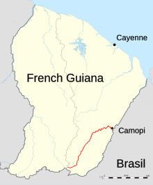
The Camopi is a 244 kilometres (152 mi) long river in French Guiana.[1] It rises in the south of the country, flowing northeast until it reaches the river Oyapock at the town of Camopi, on the border with Brazil.
| Camopi | |
|---|---|
 | |
 | |
| Location | |
| Country | French Guiana |
| Physical characteristics | |
| Source | |
| • location | French Guiana |
| • coordinates | 2.3406°N 53.311°W |
| Mouth | |
• location | Oyapock |
• coordinates | 3°10′15″N 52°19′53″W |
| Length | 244 km (152 mi) |
| Basin features | |
| Progression | Oyapock→ Atlantic Ocean |
References
Authority control | |
|---|---|
| General |
|
| National libraries | |
Текст в блоке "Читать" взят с сайта "Википедия" и доступен по лицензии Creative Commons Attribution-ShareAlike; в отдельных случаях могут действовать дополнительные условия.
Другой контент может иметь иную лицензию. Перед использованием материалов сайта WikiSort.org внимательно изучите правила лицензирования конкретных элементов наполнения сайта.
Другой контент может иметь иную лицензию. Перед использованием материалов сайта WikiSort.org внимательно изучите правила лицензирования конкретных элементов наполнения сайта.
2019-2026
WikiSort.org - проект по пересортировке и дополнению контента Википедии
WikiSort.org - проект по пересортировке и дополнению контента Википедии