geo.wikisort.org - River
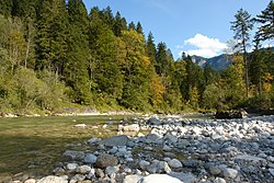
The Brandenberger Ache is a river of Bavaria, Germany, and of the Kufstein District, Tyrol, Austria.
| Brandenberger Ache | |
|---|---|
 | |
| Location | |
| Countries | Germany and Austria |
| States | Bavaria and Tyrol |
| Physical characteristics | |
| Source | |
| • location | Spitzingsee |
| Mouth | |
• location | Inn |
• coordinates | 47.4468°N 11.8977°E |
| Length | 37.8 km (23.5 mi) [1] |
| Basin size | 283 km2 (109 sq mi) [1] |
| Basin features | |
| Progression | Inn→ Danube→ Black Sea |
It is a 38 km (24 mi) long left tributary of the Inn. It starts as the outflow of the Spitzingsee in southern Bavaria, and flows from North to South to the town of Rattenberg where it merges with the Inn.
References
- Complete table of the Bavarian Waterbody Register by the Bavarian State Office for the Environment (xls, 10.3 MB)
На других языках
[de] Brandenberger Ache
Die Brandenberger Ache ist ein 22 km langer linker Nebenfluss des Inn im Tiroler Unterland. Sie durchbricht die Nördlichen Kalkalpen in mehreren Schluchten, die einen wertvollen Lebensraum für zahlreiche Tier- und Pflanzenarten darstellen, und wurde zum Naturdenkmal erklärt.- [en] Brandenberger Ache
[ru] Бранденбергер-Ахе
Бранденбергер-Ахе[1] (нем. Brandenberger Ache) — река в Баварии (Германия) и округе Куфштайн (Австрия). Левый приток Инна, впадающего в Дунай.Текст в блоке "Читать" взят с сайта "Википедия" и доступен по лицензии Creative Commons Attribution-ShareAlike; в отдельных случаях могут действовать дополнительные условия.
Другой контент может иметь иную лицензию. Перед использованием материалов сайта WikiSort.org внимательно изучите правила лицензирования конкретных элементов наполнения сайта.
Другой контент может иметь иную лицензию. Перед использованием материалов сайта WikiSort.org внимательно изучите правила лицензирования конкретных элементов наполнения сайта.
2019-2025
WikiSort.org - проект по пересортировке и дополнению контента Википедии
WikiSort.org - проект по пересортировке и дополнению контента Википедии