geo.wikisort.org - River
The Branco River (Portuguese: Rio Branco; Engl: White River) is the principal affluent of the Rio Negro from the north.
| Branco River | |
|---|---|
 Branco River in Boa Vista city, Roraima state, Brazil. The Macuxi Bridge, 1.2 km (0.75 mi) long,[1] can be seen in the background. | |
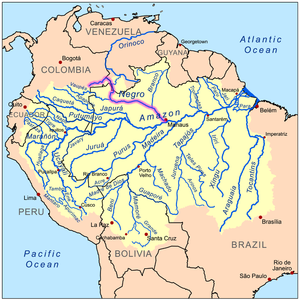 The Branco River is a tributary of the Rio Negro (highlighted on map) | |
| Native name | Rio Branco (Portuguese) |
| Location | |
| Country | Brazil |
| Physical characteristics | |
| Source | |
| • location | confluence of Takutu and Uraricoera Rivers, Roraima, Brazil |
| Mouth | |
• location | Rio Negro, Roraima, Brazil |
• coordinates | 1°23′38″S 61°50′46″W |
| Length | 560 km (350 mi)[2] |
| Basin size | 185,000 km2 (71,000 sq mi) |
| Discharge | |
| • location | Confluence of Rio Negro, Roraima State |
| • average | 5,400 m3/s (190,000 cu ft/s) |
| Basin features | |
| Tributaries | |
| • left | Takutu, Anauá |
| • right | Uraricoera, Mucajai, Catrimani |
Basin
The river drains the Guayanan Highlands moist forests ecoregion.[3] It is enriched by many streams from the Tepui highlands which separate Venezuela and Guyana from Brazil. Its two upper main tributaries are the Uraricoera and the Takutu.[4] The latter almost links its sources with those of the Essequibo; during floods headwaters of the Branco and those of the Essequibo are connected, allowing a level of exchange in the aquatic fauna (such as fish) between the two systems.[5]
The Branco flows nearly south, and finds its way into the Negro through several channels and a chain of lagoons similar to those of the latter river. It is 350 miles (560 km) long, up to its Uraricoera confluence. It has numerous islands, and, 235 miles (378 km) above its mouth, it is broken by a bad series of rapids.
Water chemistry
As suggested by its name, the Branco (literally "white" in Portuguese) has whitish water that may appear almost milky due to the inorganic sediments it carries.[6] It is traditionally considered a whitewater river,[7][8] although the major seasonal fluctuations in its physico-chemical characteristics makes a classification difficult and some consider it clearwater.[9][10] Especially the river's upper parts at the headwaters are clear and flow through rocky country, leading to the suggestion that sediments mainly originate from the lower parts.[6] Furthermore, its chemistry and color may contradict each other compared to the traditional Amazonian river classifications.[9] The Branco River has pH 6–7 and low levels of dissolved organic carbon.[10]
Alfred Russel Wallace mentioned the coloration in "On the Rio Negro", a paper read at the 13 June 1853 meeting of the Royal Geographical Society, in which he said: "[The Rio Branco] is white to a remarkable degree, its waters being actually milky in appearance". Alexander von Humboldt attributed the color to the presence of silicates in the water, principally mica and talc.[11] There is a visible contrast with the waters of the Rio Negro at the confluence of the two rivers. The Rio Negro is a blackwater river with dark tea-colored acidic water (pH 3.5–4.5) that contains high levels of dissolved organic carbon.[10]
River capture
Until approximately 20,000 years ago the headwaters of the Branco River flowed not into the Amazon, but via the Takutu Graben in the Rupununi area of Guyana towards the Caribbean.[12] Currently in the rainy season much of the Rupununi area floods, with water draining both to the Amazon (via the Branco River) and the Essequibo River.[5]
Citations
Notes
- UOL. Turismo em Boa Vista. Access on Feb 17 2012.
- Ziesler, R.; Ardizzone, G.D. (1979). "Amazon River System". The Inland waters of Latin America. Food and Agriculture Organization of the United Nations. ISBN 92-5-000780-9. Archived from the original on 8 November 2014.
- Sears, Robin, South America: Southern Venezuela, northern Brazil, western Guyana, and eastern Colombia (NT0124), WWF: World Wildlife Fund, retrieved 2017-04-01
- "Map of the Branco or Parimé River and of the Caratirimani Uararicapará Majari, Tacutú and Mahú Rivers". World Digital Library. Retrieved 27 April 2013.
- Quinn, J.A.; S.L. Woodward, eds. (2015). Earth's Landscape: An Encyclopedia of the World's Geographic Features. Vol. 1. p. 142. ISBN 978-1-61069-445-2.
- The Alfred Russel Wallace page: On the Rio Negro. Retrieved 10 October 2017.
- Venticinque; Forsberg; Barthem; et al. (2016). "An explicit GIS-based river basin framework for aquatic ecosystem conservation in the Amazon". Earth Syst. Sci. Data. 8: 651–661. doi:10.5194/essd-8-651-2016.
- Val, A.L.; V.M.F. de Almeida-Val; D.J. Randall, eds. (2013). Fish Physiology: The Physiology of Tropical Fishes. p. 27. ISBN 978-0-12350-445-6.
- Ríos-Villamizar, E.A.; M.T.F. Piedade; J.G. da Costa; J.M. Adeney; J. Junk (2013). "Chemistry of different Amazonian water types for river classification: A preliminary review".
- de Souza kodra, A.; M.N. Fernandes; W.L. Paxiúba Duncan (2014). "Effect of clearwater on osmoregulation of cururu ray, Potamotrygon sp. (Chondrichthes; Potamotrogonidae), an endemic species from blackwater river". Scientia Amazonia. 3 (1): 15–24.
- "Alexander von Humboldt, Personal Narrative of Travels to the Equinoctial Regions of America During the Years 1799-1804, (chapter 25). Henry G. Bohn, London, 1853". Archived from the original on 2016-03-03. Retrieved 2015-05-13.
- Cremon, É. H. (2016). Evolução quaternária do Rio Branco - norte da Amazônia - com base em dados orbitais e geológicos. Tese (Doutorado em Sensoriamento Remoto) - Instituto Nacional de Pesquisas Espaciais (INPE), São José dos Campos.
References
- Encyclopædia Britannica Online.com: "Branco River" . retrieved 19 September 2009.
| Wikimedia Commons has media related to Rio Branco (Rio Negro tributary). |
На других языках
[de] Rio Branco (Rio Negro)
Der Rio Branco [.mw-parser-output .IPA a{text-decoration:none}ˌχiu ˈbɾãku] (portug. für „weißer Fluss“) ist ein unter diesem Namen 560 km und mit dem Rio Uraricoera 1439 km langer, linker Nebenfluss des Rio Negro und verläuft im Norden Brasiliens. Mit einer Wasserführung von 5300 m³/s ist er der größte Nebenfluss des Rio Negro.- [en] Branco River
[es] Río Branco (Roraima)
El río Branco (en español, «río Blanco») es un río amazónico brasileño, el principal afluente por la margen septentrional del río Negro, que discurre íntegramente por el estado de Roraima. Tiene una longitud de 560 km,[1] aunque con una de sus fuentes, el río Uraricoera, alcanza los 1.430 km.[ru] Риу-Бранку (приток Риу-Негру)
Ри́у-Бра́нку (порт. Rio Branco) — река в Бразилии в штате Рорайма. Длина реки составляет около 584 км, площадь бассейна около 195 тыс. км².Другой контент может иметь иную лицензию. Перед использованием материалов сайта WikiSort.org внимательно изучите правила лицензирования конкретных элементов наполнения сайта.
WikiSort.org - проект по пересортировке и дополнению контента Википедии