geo.wikisort.org - River
The Big Blue River is the largest tributary of the Kansas River. The river flows for approximately 359 miles (578 km)[2] from central Nebraska into Kansas, until its confluence with the Kansas River at Manhattan.
| Big Blue River | |
|---|---|
 Big Blue River above Manhattan, Kansas | |
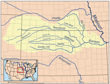 Map of the Kansas River drainage basin showing the Big Blue and Little Blue rivers | |
| Native name | Great Blue Earth River (Kansa) |
| Location | |
| Country | United States |
| State | Nebraska, Kansas |
| Region | Great Plains |
| Cities | Manhattan, KS, Beatrice, NE, Crete, NE, Seward, NE |
| Physical characteristics | |
| Source | |
| • location | Near Aurora, NE, Great Plains, United States |
| • coordinates | 40°57′00″N 098°04′31″W[1] |
| Mouth | Kansas River |
• location | Near Manhattan, Great Plains, United States |
• coordinates | 39°11′17″N 096°31′40″W[1] |
| Length | 359 mi (578 km), South[2] |
| Discharge | |
| • location | Manhattan, KS[3] |
| • average | 982 cu ft/s (27.8 m3/s)[3] |
| • minimum | 8 cu ft/s (0.23 m3/s) |
| • maximum | 18,000 cu ft/s (510 m3/s) |
| Basin features | |
| River system | Kansas River watershed |
| Tributaries | |
| • left | Little Blue River, West Fork of the Little Blue River |
It was given its name by the Kansa tribe of Native Americans, who lived at its mouth from 1780 to 1830, and who called it the Great Blue Earth River.
River course
The river passes through mostly agricultural land.[4] Some of the larger towns along its course, in addition to Manhattan, Kansas, include Beatrice, Nebraska; Crete, Nebraska; and Seward, Nebraska.

Shortly before intersecting with the Kansas River, the Big Blue discharges its waters into a reservoir called Tuttle Creek Lake, which lies slightly northeast of Manhattan. The reservoir is a man-made flood-control measure, held back by a dam composed of the limestone, silt, and gypsum dredged out of the floodplain by bulldozers left to rust underneath the flooded area. The land surrounding the reservoir is a state park area, although the Great Flood of 1993 decimated much of the northern area.
The river continues as the outflow from Tuttle Creek Lake for approximately five miles before intersecting with the Kansas River east of Manhattan.
Water rights
Nebraska and Kansas have entered into an agreement of appropriation where Nebraska has full use of the river's water, except that from May 1 to September 30 Nebraska must allow a certain variable flow to pass into Kansas.[5] To date, there has been no shortage of water in the river.
See also
- List of Kansas rivers
- Lakes, reservoirs, and dams in Kansas
- List of Nebraska rivers
References
- "Big Blue River". Geographic Names Information System. United States Geological Survey. 1978-10-13. Retrieved 2013-08-17.
- U.S. Geological Survey. National Hydrography Dataset high-resolution flowline data. The National Map Archived 2012-03-29 at the Wayback Machine, accessed March 30, 2011
- "USGS Current Conditions for USGS 06887000 BIG BLUE R NR MANHATTAN, KS".
- "Big Blue River Basin". Archived from the original (English) on 2008-10-06. Retrieved 2008-08-13.
- "Kansas-Nebraska Big Blue River Compact" (PDF). 1971. Archived from the original (PDF) on 2009-03-26.
External links
Authority control | |
|---|---|
| General |
|
| National libraries | |
| Other | |
На других языках
- [en] Big Blue River (Kansas)
[es] Río Big Blue
El río Big Blue (en inglés, Big Blue River, que literalmente significa «río Gran Azul») es un río del Medio Oeste de los Estados Unidos, uno de los principales afluentes del río Kansas. Tiene una longitud de 578 km[1] y drena una cuenca de 23.300 km²[2] (similar a países como Yibuti y Belice, y algo menor que Macedonia del Norte o Ruanda).Другой контент может иметь иную лицензию. Перед использованием материалов сайта WikiSort.org внимательно изучите правила лицензирования конкретных элементов наполнения сайта.
WikiSort.org - проект по пересортировке и дополнению контента Википедии