geo.wikisort.org - River
The Barima River is a tributary of the Orinoco River, entering 6 kilometres (4 mi) from the Atlantic Ocean. It originates from the Imataka Mountains in Guyana,[1] flowing for approximately 340 kilometres (210 mi) before entering Venezuela about 80 kilometres (50 mi) from its mouth.
| Barima River | |
|---|---|
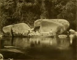 Arawatta Rock in the Barima River | |
 Location of mouth | |
| Location | |
| Country | Guyana, Venezuela |
| Physical characteristics | |
| Mouth | |
• coordinates | 8°35′N 60°25′W |
Features
Early recorded explorations of the Barima were made by Robert Hermann Schomburgk, which was mapped as far as the tributary Rocky River.[2]
The head of the Barima rises in a steep gorge of the Imataka mountains, 950 ft (290 m) above sea level.[2] Near the Duquari Creek, the Arawatta Rock, a distinct large granite rock, is located.[1]
Settlements
Mabaruma,[3] Koriabo,[4] and Morawhanna are Barima-Waini Region communities on the Barima River.
See also
References
- Harrison, John Burchmore; Fowler, Frank; Anderson, Charles Wilgress (1908). The geology of the goldfields of British Guiana. Smithsonian Libraries. [London] Dulau & Co. pp. 107, 109.
- Dixon, George G. (1895). "Four Months of Travel in British Guiana". The Geographical Journal. 5 (4): 343–344. doi:10.2307/1774100. ISSN 0016-7398.
- "Gov't re-establishes Mabaruma-Morawhanna road link". Guyana Chronicle. Retrieved 31 August 2020.
- "SPANISH RAIDS ON DUTCH TERRITORY (1758-1768)". Guyana.org. Retrieved 31 August 2020.
Wikimedia Commons has media related to Barima River.
На других языках
- [en] Barima River
[it] Barima
Il Barima (in spagnolo Río Barima) è un affluente del fiume Orinoco, dove sfocia a soli sette chilometri dall'oceano Atlantico. Nasce in Guyana (nella zona che il Venezuela reclama come parte della Guayana Esequiba) dove scorre per circa 380 chilometri, prima di entrare nel Venezuela a circa 90 chilometri dalla sua foce.[ru] Барима
Барима (англ. Barima, исп. Barima) — река в Южной Америке, протекает по территории Гайаны в регионе Барима-Уайни, устьевая часть в Венесуэле, в штате Дельта-Амакуро. Длина около 400 км[1].Текст в блоке "Читать" взят с сайта "Википедия" и доступен по лицензии Creative Commons Attribution-ShareAlike; в отдельных случаях могут действовать дополнительные условия.
Другой контент может иметь иную лицензию. Перед использованием материалов сайта WikiSort.org внимательно изучите правила лицензирования конкретных элементов наполнения сайта.
Другой контент может иметь иную лицензию. Перед использованием материалов сайта WikiSort.org внимательно изучите правила лицензирования конкретных элементов наполнения сайта.
2019-2026
WikiSort.org - проект по пересортировке и дополнению контента Википедии
WikiSort.org - проект по пересортировке и дополнению контента Википедии