geo.wikisort.org - River
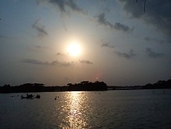
The Baleshwari River is located in Bangladesh, forming part of the eastern border of Bagerhat District and the western border of Barguna District.[1] It borders on the east the largest mangrove forest in the world, in the Ganges-Brahmaputra delta, the Bangladesh part of which is set aside as the Sundarbans Reserve Forest. The Baleshwar River flows south into the Haringhata River, which flows into the Bay of Bengal.
| Baleshwari River | |
|---|---|
 Baleshwar River | |
| Location | |
| Country | Bangladesh |
| Region | Barisal Division |
| Districts | Bagerhat and Barguna |
| Physical characteristics | |
| Source | Kaliganga River |
| • coordinates | 22°44′03″N 89°59′50″E |
| Mouth | Haringhata River (to the Bay of Bengal) |
• coordinates | 22°29′25″N 89°58′48″E |
| Length | 146 km (91 mi) |
See also
- Bihanga Island, island in the Baleshwari river.
References
- Kamal, HM Khaled (2012). "Bagerhat District". In Islam, Sirajul; Jamal, Ahmed A. (eds.). Banglapedia: National Encyclopedia of Bangladesh (Second ed.). Asiatic Society of Bangladesh.
На других языках
- [en] Baleshwari River
[es] Río Baleshwar
El río Baleshwar es un río de Bangladés. Este río confina al bosque de mangle más grande que existe en el mundo, en el delta de Sundarbans, localizado en la boca del río Ganges. El delta está catalogado como Patrimonio de la Humanidad de la Unesco.Текст в блоке "Читать" взят с сайта "Википедия" и доступен по лицензии Creative Commons Attribution-ShareAlike; в отдельных случаях могут действовать дополнительные условия.
Другой контент может иметь иную лицензию. Перед использованием материалов сайта WikiSort.org внимательно изучите правила лицензирования конкретных элементов наполнения сайта.
Другой контент может иметь иную лицензию. Перед использованием материалов сайта WikiSort.org внимательно изучите правила лицензирования конкретных элементов наполнения сайта.
2019-2025
WikiSort.org - проект по пересортировке и дополнению контента Википедии
WikiSort.org - проект по пересортировке и дополнению контента Википедии