geo.wikisort.org - River
The Austreberthe is an 18-km river in the Seine-Maritime.[1] Its source is the village of Sainte-Austreberthe. It meets the Seine at Duclair.
| Austreberthe | |
|---|---|
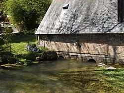
 A view of the Austreberthe | |
| Location | |
| Country | France |
| Physical characteristics | |
| Source | |
| • location | Normandy |
| Mouth | |
• location | Seine |
• coordinates | 49°28′42″N 0°52′17″E |
| Length | 18 km (11 mi) |
| Basin features | |
| Progression | Seine→ English Channel |
The Austreberthe is crossed by the Barentin Viaduct, a noteworthy 30 metre high brick railway bridge built in 1846, about 19-km from Rouen.
References
External links
- (in French) Au fil de l'Austreberthe...
На других языках
[de] Austreberthe (Fluss)
Die Austreberthe ist ein kleiner Fluss in Frankreich, der im Département Seine-Maritime in der Region Normandie verläuft. Sie entspringt im Ortsgebiet der Gemeinde Sainte-Austreberthe bei der Kapelle der Heiligen Austreberta, entwässert generell Richtung Südwest und mündet nach rund 18 Kilometern im Gemeindegebiet von Duclair als rechter Nebenfluss in die Seine. Das Mündungsgebiet liegt im Regionalen Naturpark Boucles de la Seine Normande. Bei Barentin quert der Fluss die Autobahn A150 sowie die Bahnstrecke Paris-Saint-Lazare–Le Havre auf einem sehenswerten Eisenbahnviadukt.- [en] Austreberthe
Текст в блоке "Читать" взят с сайта "Википедия" и доступен по лицензии Creative Commons Attribution-ShareAlike; в отдельных случаях могут действовать дополнительные условия.
Другой контент может иметь иную лицензию. Перед использованием материалов сайта WikiSort.org внимательно изучите правила лицензирования конкретных элементов наполнения сайта.
Другой контент может иметь иную лицензию. Перед использованием материалов сайта WikiSort.org внимательно изучите правила лицензирования конкретных элементов наполнения сайта.
2019-2025
WikiSort.org - проект по пересортировке и дополнению контента Википедии
WikiSort.org - проект по пересортировке и дополнению контента Википедии

