geo.wikisort.org - River
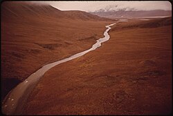
The Atigun River /ˈætəɡən/ is a river in the Endicott Mountains in northern Alaska. The source is a glacier terminus, from which it flows northeast to the Sagavanirktok River 20 miles south of its junction with the Ribdon River. It is 45 miles long.[1]
| Atigun River | |
|---|---|
 Atigun River flowing towards the mouth of Atigun Gorge (Dennis Cowals, 1973) | |
 Location in Alaska | |
| Physical characteristics | |
| Source | |
| • coordinates | 68.1219444°N 149.4591667°W |
| Mouth | |
• coordinates | 68.5252778°N 149.0033333°W |
• elevation | 621 meters |
| Length | 45 miles |
| Basin features | |
| River system | Sagavanirktok River |
References
- "GNIS Detail - Atigun River". geonames.usgs.gov. Retrieved 27 December 2020.
Текст в блоке "Читать" взят с сайта "Википедия" и доступен по лицензии Creative Commons Attribution-ShareAlike; в отдельных случаях могут действовать дополнительные условия.
Другой контент может иметь иную лицензию. Перед использованием материалов сайта WikiSort.org внимательно изучите правила лицензирования конкретных элементов наполнения сайта.
Другой контент может иметь иную лицензию. Перед использованием материалов сайта WikiSort.org внимательно изучите правила лицензирования конкретных элементов наполнения сайта.
2019-2025
WikiSort.org - проект по пересортировке и дополнению контента Википедии
WikiSort.org - проект по пересортировке и дополнению контента Википедии