geo.wikisort.org - River
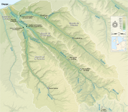
The river Arques (French pronunciation: [aʁk]) is a watercourse located in the Seine-Maritime département of the Normandy region of north-western France.
| Arques | |
|---|---|
 Arques drainage basin | |
| Location | |
| Country | France |
| Physical characteristics | |
| Source | |
| • location | Pays de Caux |
| Mouth | |
• location | The English Channel at Dieppe |
• coordinates | 49°55′54″N 1°5′9″E |
| Length | 6 km (3.7 mi) |
| Basin size | 1,050 km2 (410 sq mi) |
| Discharge | |
| • average | 10.2 m3/s (360 cu ft/s) |
Only 6 kilometres in length, the river is formed by the confluence of three rivers at Arques-la-Bataille: the Eaulne, the Béthune and the Varenne which drain the pays de Caux and the pays de Bray. The Béthune is also considered the upper part of the Arques, which is then 67 km (42 mi) long.[1] The last part of its course takes it past the industrial zone of Rouxmesnil-Bouteilles and it then forms the waters of the port of Dieppe.
See also
- French water management scheme
References
На других языках
[de] Arques (Fluss)
Der Arques ist ein Fluss in Frankreich, der im Département Seine-Maritime in der Region Normandie verläuft. Er entsteht durch Vereinigung der Flüsse Béthune, Varenne und Eaulne im Gemeindegebiet von Arques-la-Bataille, entwässert generell in nordwestlicher Richtung und mündet nach rund 6[2] Kilometern im Stadtgebiet von Dieppe in den Ärmelkanal.- [en] Arques (river)
Текст в блоке "Читать" взят с сайта "Википедия" и доступен по лицензии Creative Commons Attribution-ShareAlike; в отдельных случаях могут действовать дополнительные условия.
Другой контент может иметь иную лицензию. Перед использованием материалов сайта WikiSort.org внимательно изучите правила лицензирования конкретных элементов наполнения сайта.
Другой контент может иметь иную лицензию. Перед использованием материалов сайта WikiSort.org внимательно изучите правила лицензирования конкретных элементов наполнения сайта.
2019-2025
WikiSort.org - проект по пересортировке и дополнению контента Википедии
WikiSort.org - проект по пересортировке и дополнению контента Википедии