geo.wikisort.org - River
The Andelle (French pronunciation: [ɑ̃dɛl]) is a river of Normandy, France, 56.9 kilometres (35.4 mi) in length, flowing through the departments of Seine-Maritime and Eure. It is a right tributary of the Seine.[1]
| Andelle | |
|---|---|
 The Andelle at Radepont | |
 | |
| Location | |
| Country | France |
| Physical characteristics | |
| Source | |
| • location | Serqueux |
| • elevation | 201 m (659 ft) |
| Mouth | |
• location | The Seine at Pîtres |
• coordinates | 49°18′40″N 1°13′28″E |
| Length | 56.9 km (35.4 mi) |
| Basin size | 740 km2 (290 sq mi) |
| Discharge | |
| • average | 7.2 m3/s (250 cu ft/s) |
| Basin features | |
| Progression | Seine→ English Channel |
Geography
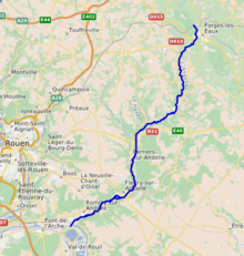
The Andelle has its source in the Pays de Bray in the territory of the commune of Serqueux. Taking a southward journey, it flows through two French départements:
- In Seine-Maritime : Forges-les-Eaux, Rouvray-Catillon, Sigy-en-Bray, Nolléval, Morville-sur-Andelle, Le Héron, Elbeuf-sur-Andelle and Croisy-sur-Andelle.
- In the Eure : Vascœuil, Perruel, Perriers-sur-Andelle, Charleval, Fleury-sur-Andelle, Radepont, Douville-sur-Andelle, Pont-Saint-Pierre, Romilly-sur-Andelle and Pîtres where it joins the Seine on its right bank.
The average flow of the Andelle at Pitres, where it joins the Seine, is 7.2 m³ / second.[2]
See also
- French water management scheme
Bibliography
- Albert Hennetier, Aux sources normandes: Promenade au fil des rivières en Seine-Maritime, Ed. Bertout, Luneray, 2006 ISBN 2867436230
References
- Sandre. "Fiche cours d'eau - L'Andelle (H32-0400)".
- "Débits des principaux cours d'eau du Pays de Bray selon l'AREHN" (PDF). Archived from the original (PDF) on 2008-12-08. Retrieved 2008-10-19.
Authority control | |
|---|---|
| General |
|
| National libraries | |
| Other |
|
This Seine-Maritime geographical article is a stub. You can help Wikipedia by expanding it. |
На других языках
[de] Andelle
Die Andelle ist ein Fluss in Frankreich, der in der Region Normandie verläuft. Sie entspringt in der Landschaft Pays de Bray, im Gemeindegebiet von Serqueux, entwässert generell in südwestlicher Richtung durch die historische Provinz Vexin Normand und mündet nach rund 57[2] Kilometern im Gemeindegebiet von Pîtres als rechter Nebenfluss in die Seine. Auf ihrem Weg durchquert die Andelle die Départements Seine-Maritime und Eure.- [en] Andelle
[ru] Андель (река)
Андель (фр. Andelle) — река в Нормандии[1]. Длина реки 56,8 километров, а бассейн 740 км². Средний расход воды — 7,2 м³/с[2]. Приток Сены.Текст в блоке "Читать" взят с сайта "Википедия" и доступен по лицензии Creative Commons Attribution-ShareAlike; в отдельных случаях могут действовать дополнительные условия.
Другой контент может иметь иную лицензию. Перед использованием материалов сайта WikiSort.org внимательно изучите правила лицензирования конкретных элементов наполнения сайта.
Другой контент может иметь иную лицензию. Перед использованием материалов сайта WikiSort.org внимательно изучите правила лицензирования конкретных элементов наполнения сайта.
2019-2026
WikiSort.org - проект по пересортировке и дополнению контента Википедии
WikiSort.org - проект по пересортировке и дополнению контента Википедии