geo.wikisort.org - River
The Amburayan River is a river in the northeastern portion of island of Luzon in the Philippines. It originates from the Cordillera mountains and traverses the provinces of Benguet, La Union, and Ilocos Sur. With a total length of 96 km (60 mi) where it empties into the now (West PHILIPPINE Sea) then formerly South China Sea.[1]
| Amburayan River | |
|---|---|
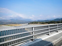
 View from the Amburayan Bridge along Manila North Road | |
 Amburayan River mouth  Amburayan River (Philippines) | |
| Location | |
| Country | Philippines |
| Region |
|
| Province |
|
| City/municipality |
|
| Physical characteristics | |
| Source | Cordillera Mountains |
| • location | Mount Osdung Kibungan, Benguet |
| • elevation | 8,586 ft (2,617 m) |
| Mouth | South China Sea |
• location |
|
• coordinates | 16°55′15.7″N 120°24′39″E |
• elevation | 0 m (0 ft) |
| Length | 96 km (60 mi) |
| Basin size | 1,319 km2 (509 sq mi) |
| Basin features | |
| Tributaries | |
| • right | Bakun River |
The river serves as the boundary between the provinces of Ilocos Sur and La Union.[2][3]
Source and course
The river's headwaters are a confluence of smaller creeks along the south of barangay Lubo, in Kibungan. Several other tributary creeks merge with the river as it flows along Atok and Kapangan. It then flows along the Sugpon–San Gabriel boundary, the Sugpon–Santol boundary, the Sugpon–Sudipen boundary, the Sudipen–Alilem boundary, the Sudipen–Tagudin boundary, and finally at the Tagudin–Bangar boundary, where its river mouth is located.
In culture
In the Ilocano epic, Biag ni Lam-ang, the hero Lam-ang came to bathe in the Amburayan, as he was soaked in dirt and blood after a battle with headhunters. Assisted by maidens from a nearby village, he shed the dirt and blood which polluted the river and killed the fish and other animals in the water.[citation needed]
References
- See, Dexter A. (27 November 2014). "USAID provides P20 M to protect Amburayan River". Manila Standard Today. Retrieved 12 January 2015.
- "Natural Sceneries: Amburayan River". Province of La Union (Official Website). Archived from the original on 17 January 2015. Retrieved 12 January 2015.
- "About Sugpon". Municipality of Sugpon, Ilocos Sur (official website). 5 July 2014. Archived from the original on 8 November 2014. Retrieved 12 January 2015.
На других языках
[de] Amburayan
Der Amburayan (eng.: Amburayan River) ist ein Fluss in der Provinz Benguet und La Union auf den Philippinen. Seine Hauptquellen liegen im Gebirge der Cordillera Central an den Flanken der über 2000 Meter hohen Berge Mount Labo und Mount Osbong. Die Grenze zwischen den Provinzen La Union und Ilocos Sur orientiert sich am Flusslauf des Amburayan bis zu seiner Mündung in das Südchinesische Meer, er hat ein Wassereinzugsgebiet von 1386 km².- [en] Amburayan River
Другой контент может иметь иную лицензию. Перед использованием материалов сайта WikiSort.org внимательно изучите правила лицензирования конкретных элементов наполнения сайта.
WikiSort.org - проект по пересортировке и дополнению контента Википедии