geo.wikisort.org - River
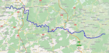
The Amblève (French, French pronunciation: [ɑ̃blɛv]) or Amel (German, French pronunciation: [ˈaːml̩]) is a 93-kilometre (58 mi) long river in eastern Belgium in the province of Liège. It is a right tributary of the river Ourthe. It rises near Büllingen in the High Fens or Hoge Venen (Dutch), Hohes Venn (German), and Hautes Fagnes (French), close to the border with Germany.
This article does not cite any sources. (April 2008) |
| Amblève | |
|---|---|
 | |
 | |
| Location | |
| Country | Belgium |
| Physical characteristics | |
| Length | 93 km (58 mi) |
| Basin size | 1,077 km2 (416 sq mi) |
| Discharge | |
| • average | 19.5 m3/s (690 cu ft/s) |
| Basin features | |
| Progression | Ourthe→ Meuse→ North Sea |
Tributaries of the Amblève are the rivers Chefna, Ninglinspo, Warche, Eau Rouge, Salm and Lienne. The Amblève flows through the towns of Amel, Stavelot, Trois-Ponts, Remouchamps, and Aywaille. The Amblève joins the river Ourthe in Comblain-au-Pont.
Sites

At the village of Coo (near Trois-Ponts) is the Coo Waterfall, which at 15 metres (49 ft) tall is not the highest but one of the better known waterfalls in Belgium. The waterfall was created artificially in the 18th century when local monks cut through a bend in the river to feed a watermill. The dried out river bed is now used as the lower storage basin for the Coo-Trois-Ponts Hydroelectric Power Station.

A curiosity of Lorcé, a nearby village, is the unusual design of the dam located at a place called "Fang-Naze" or "Fagne-Naze." Built between 1928 and 1932, it captures about 50,000 cubic metres (41 acre⋅ft) of water, which is then led through a 3,460-metre (11,350 ft) long tunnel cut out of the hill, before falling 40 metres (130 ft) into the turbines of the power plant "Heid Ile" at Nonceveux part of Aywaille.
On the right bank near Sprimont is the site of the Belle Roche cave, the oldest known place of human occupation of the Benelux (dating back about 500,000 years).
The "Fond de Quareux" stretch of the river near Nonceveux is listed as one of Wallonia's Major Heritage sites.
This Liège Province location article is a stub. You can help Wikipedia by expanding it. |
На других языках
[de] Amel (Fluss)
Die Amel (französisch: Amblève) ist ein 93 km langer Nebenfluss zur Ourthe in Ostbelgien (Provinz Lüttich). Die Amel ist Teil des Einzugsgebietes der Maas. Ihre Quelle befindet sich nahe Honsfeld in der belgischen Eifel, an der Grenze zwischen den Gemeinden Amel und Büllingen auf 600 m O.P. Nebenflüsse der Amel sind die Warche und die Salm. Le Rubicon ist ein unterirdischer Nebenfluss der Amel. Er hat die Grotten von Remouchamps geformt. Le Rubicon ist in diesen seit 1912 der Öffentlichkeit zugänglichen Grotten auf 600 Meter befahrbar.- [en] Amblève (river)
[es] Río Ambleve
El río Ambleve[1] (en alemán: Amel; en francés: Amblève) es un río de Bélgica situado en la provincia de Lieja. Nace en el Honsfeld de las Hautes Fagnes, en el municipio de Büllingen, a una altitud de aproximadamente 600 metros. Desemboca en el río Ourthe, cerca de Comblain-au-Pont.[it] Amblève (fiume)
L'Amblève è un fiume belga che percorre la regione belga della Vallonia e confluisce, dopo 93 km di percorso, nella Ourthe, presso Comblain-au-Pont.[ru] Амблев
Амблев[1], в верховьях — Амел[1] (нем. Amel, фр. Amblève) — река в Бельгии, протекает по провинции Льеж. Правый приток реки Урт. Длина реки около 90 км[2]. Площадь бассейна реки составляет 1070 км²[2].Другой контент может иметь иную лицензию. Перед использованием материалов сайта WikiSort.org внимательно изучите правила лицензирования конкретных элементов наполнения сайта.
WikiSort.org - проект по пересортировке и дополнению контента Википедии