geo.wikisort.org - River
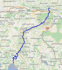
The Alz is a river in Bavaria, southern Germany, the only discharge of the Chiemsee. Its origin is on the northern shore near Seebruck. It is a right tributary of the Inn, into which it flows in Marktl. Other towns on the Alz are Altenmarkt an der Alz, Trostberg, Garching an der Alz and Burgkirchen an der Alz.
| Alz | |
|---|---|
 | |
 | |
| Location | |
| Country | Germany |
| Physical characteristics | |
| Source | |
| • location | Chiemsee |
| • elevation | 518 m (1,699 ft) |
| Mouth | |
• location | Inn |
• coordinates | 48°16′12″N 12°49′3″E |
| Length | 67.3 km (41.8 mi) [1] |
| Basin size | 2,239 km2 (864 sq mi) [1] |
| Discharge | |
| • average | ±75 m3/s (2,600 cu ft/s) |
| Basin features | |
| Progression | Inn→ Danube→ Black Sea |
The Alz is divided into the Obere Alz (upper Alz) and the Untere Alz (lower Alz). The section from the Chiemsee down to Altenmarkt is called the Obere Alz. The section from Altenmarkt to the mouth in Marktl is called the Untere Alz.
The Traun, a 29 km (18 mi) river flowing past the regional administrative center of Traunstein, is a tributary of the Alz.
Etymology
From pre-indoeuropean *alz "swamp, alder".[citation needed]
References
- Complete table of the Bavarian Waterbody Register by the Bavarian State Office for the Environment (xls, 10.3 MB)
External links
- Wasserwirtschaftsamt Traunstein, Die Alz (in German)
Authority control | |
|---|---|
| General |
|
| National libraries | |
На других языках
[de] Alz
Die Alz ist der Abfluss des Chiemsees. Sie verlässt den Chiemsee am nördlichsten Punkt bei Seebruck und mündet nach 63 km bei der Alzspitze, etwa 2,5 km nordwestlich von Marktl, in den Inn. Rechnet man die 8 km südlich in den Chiemsee mündende Tiroler Achen (79 km, mit Quellfluss Kitzbühler Ache) hinzu, so ergibt sich eine Gesamtlänge von 150 km. Ihr natürlicher mittlerer Abfluss (ohne Wasserableitungen) betrüge etwa 69 m³/s, womit die Alz (nach der Salzach) der zweitgrößte Nebenfluss des Inns ist.- [en] Alz
[it] Alz (fiume)
L'Alz è l'emissario del lago Chiemsee, che lascia nel punto più settentrionale presso Seebruck, e sfocia dopo 63 km presso l'Alzspitze, a circa 2,5 km a nord di Marktl nell'Inn. Se si aggiungono gli 8 km dalla foce nel Chiemsee del corrispondente immissario Tiroler Achen (79 km, con l'affluente Kitzbühler Ache), si raggiunge una lunghezza totale di 150 km.[ru] Альц
Альц (нем. Alz) — река в Германии, протекает по Верхней Баварии (земля Бавария). Правый приток реки Инн. Речной индекс 184[1]. Площадь бассейна реки составляет 2238,63 км²[1]. Длина реки составляет 63 км.[источник не указан 1858 дней]. Уклон реки — 2,51 м/км.[источник не указан 1858 дней].Текст в блоке "Читать" взят с сайта "Википедия" и доступен по лицензии Creative Commons Attribution-ShareAlike; в отдельных случаях могут действовать дополнительные условия.
Другой контент может иметь иную лицензию. Перед использованием материалов сайта WikiSort.org внимательно изучите правила лицензирования конкретных элементов наполнения сайта.
Другой контент может иметь иную лицензию. Перед использованием материалов сайта WikiSort.org внимательно изучите правила лицензирования конкретных элементов наполнения сайта.
2019-2026
WikiSort.org - проект по пересортировке и дополнению контента Википедии
WikiSort.org - проект по пересортировке и дополнению контента Википедии