geo.wikisort.org - River
The Akhuryan (Armenian: Ախուրյան Axuryan; Old Armenian: Ախուրեան Axurean; Russian: Арпачай or Ахурян[1]), or Arpachay (Turkish: Arpaçay)[2][3][lower-alpha 1] is a river in the South Caucasus. It originates in Armenia and flows from Lake Arpi, along the closed border with Turkey, forming part of the geographic border between the two states, until it flows into the Aras as a left tributary near Bagaran. The Akhuryan is 186 km (116 mi) long, and has a drainage basin of 9,670 km2 (3,730 sq mi).[4]
| Akhuryan | |
|---|---|
 The Akhuryan seen from the ancient Armenian capital of Ani in Turkey. | |
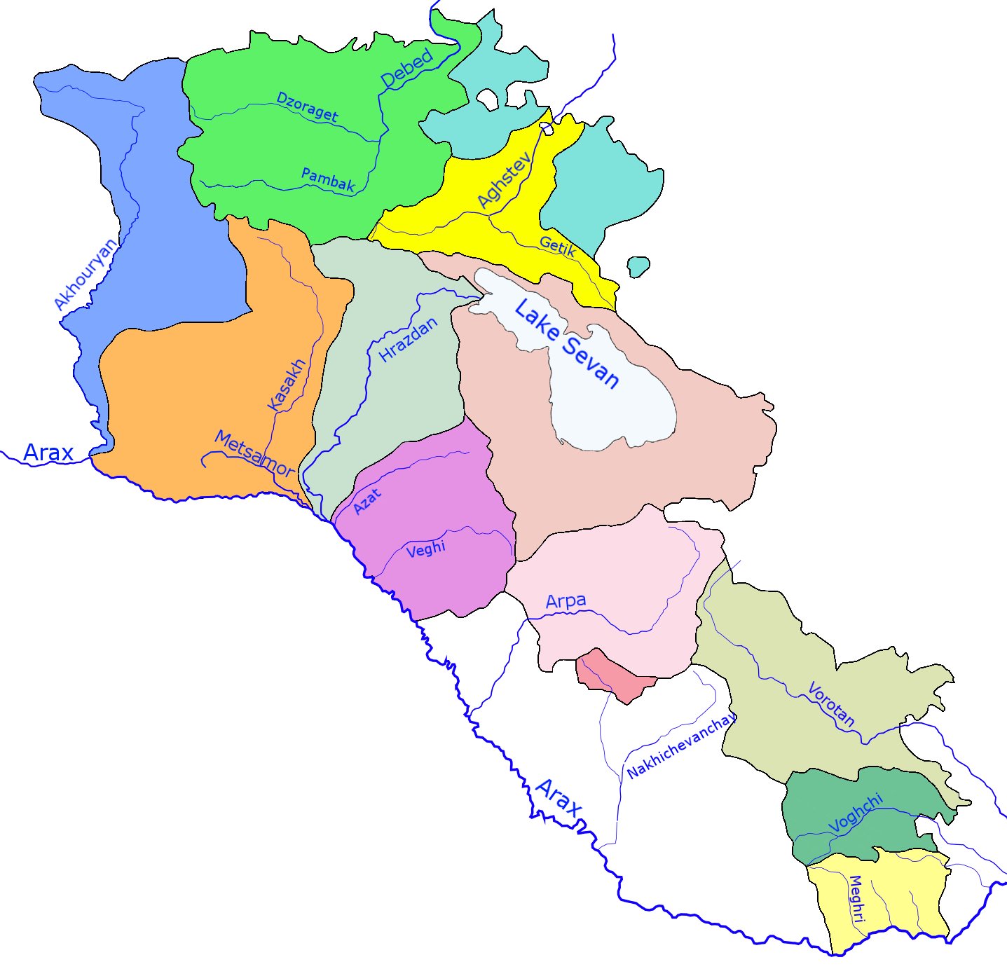 Akhuryan river and its basin (blue) within Armenia | |
 Location of mouth | |
| Native name | |
| Location | |
| Country | Armenia and Turkey |
| Physical characteristics | |
| Source | |
| • location | Lake Arpi, Shirak, Armenia |
| • elevation | 2,023 m (6,637 ft) |
| Mouth | Aras |
• location | Near Bagaran, Armenia |
• coordinates | 40.1315°N 43.6484°E |
| Length | 186 km (116 mi) |
| Basin size | 9,670 km2 (3,730 sq mi) |
| Basin features | |
| Progression | Aras→ Kura→ Caspian Sea |
Gyumri, the second largest city of Armenia, is located on the east bank of the river, which also flows past four of the twelve historical capitals of Armenia: Ani, Bagaran, Yervandashat and Yerazgavors.
History
When the Byzantine army arrived in the province of Shirak in 1041, local Armenian nobles (nakharars) assembled together against them under the command of the Pahlavuni general Vahram Pahlavouni. Vahram then selected a body of 30,000 infantry and 20,000 cavalry, forming three divisions, which fought against the Byzantines.[5] A battle ensued in which the invaders were routed with great slaughter. The fight was so ferocious that the effusion of blood flowing into the Akhurian River is said to have coloured its waters completely red.[6][7] The Byzantines left 21,000 dead behind. This victory allowed Vahram Pahlavuni along with Catholicos Petros Guedadarts to crown Gagik II king of Armenia and subsequently take the fortress of Ani, which had been in the hands of Vest Sarkis.
Bridges
Several medieval bridges once existed over the Akhuryan. The bridge at Ani may date back to the Bagratuni Dynasty.[8] More likely it dates to the thirteenth century. An inscription found nearby said that building work was done on the approach to the bridge in the early fourteenth century.[9]
The bridge's single arch has fallen, leaving only tall abutments that were perhaps part of a fortified gate.[9] Nineteenth-century travelers reported a guardhouse next to the bridge, but this has since disappeared.[9]
Notes
- Other names by which the river is known are: Arpa Çayı, Akhoran, Akhoren, Akhura, Akhuran, Akhurats’ Get, Akhuren, Ahur, Ahura, Ahuran, Ano Jur, Anu Jur, Arrp’ach’ay, Arevntyan Arrp’ach’ay, Nerk’in Arevnytyan Arp’ach’ay, Gareget, Garu Get, Metsamor, Zapadnyy Arpa-Chay, Western Arpa-Chay, Arapçayı, Arpa-Chay and Arpa-Chai River
References
- Arpachay. Brockhaus and Efron Encyclopædic Dictionary.
- Karimov, Mahmud (2007). National Encyclopedia of Azerbaijan (PDF). Baku: Azerbaijan National Academy of Sciences. ISBN 978-9952-441-01-7.
- "Arpaçay Nehri". 2012 Yılı Kars İli ÇED Raporu (PDF). 2012. Archived from the original (PDF) on January 8, 2015. Retrieved May 5, 2019.
- Ахурян, Great Soviet Encyclopedia
- History of Armenia by Father Michael Chamich from B.C. 2247 to the Year of Christ 1780, or 1229 of the Armenian era – Page 124 by Mik'ayel Ch'amch'yants'
- History of Armenia by Father Michael Chamich from B.C. 2247 to the Year of Christ 1780, or 1229... – Page 124 by Mik'ayel Ch'amch'yants'
- History of Armenia: From B.C. 2247 to the Year of Christ 1780, Or 1229 of the Armenian Era – Page 124 by Michael Chamich, John Audall, Mikʻayel Chʻamchʻyantsʻ, Hovhannēs Avdaleantsʻ – 1827
- A system of geography, popular and scientific: or A physical, political, and statistical account... – Page 143 by James Bell – 1832
- VirtualAni: The Bridge Over the Akhurian River
See also
- Geography of Armenia
- Geography of Turkey
- List of rivers of Armenia
- List of lakes of Armenia
На других языках
[de] Achurjan
Der Achurjan (armenisch Ախուրյան; türkisch Arpaçay) ist ein linker Nebenfluss des Aras in Armenien und der Türkei.- [en] Akhuryan (river)
[it] Akhurian
Il fiume Akhurian, Akhuriyan or Akhouryan (in armeno: Հրազդան, in turco: Arpaçay, in russo: Ахурян) è un fiume del Caucaso meridionale che nasce dal lago Arpi nel nord dell'Armenia per poi scorrere lungo il confine tra questo Stato e la Turchia fino a congiungersi con il Aras nei pressi di Bagaran, nella provincia armena di Armavir.[ru] Ахурян
Ахуря́н (Западный Арпачай) (арм. Ախուրյան, осман. ارپه چاى, тур. Arpaçay) — река, протекающая по Армянскому нагорью на Южном Кавказе. Является левым притоком Аракса. В верхнем течении протекает по территории Армении, в нижнем — по границе Армении с Турцией. Вытекает из Арпиличского водохранилища, впадает в Аракс близ села Багаран.Другой контент может иметь иную лицензию. Перед использованием материалов сайта WikiSort.org внимательно изучите правила лицензирования конкретных элементов наполнения сайта.
WikiSort.org - проект по пересортировке и дополнению контента Википедии