geo.wikisort.org - Fluss
Das Water of Ken ist ein Fluss in der schottischen Council Area Dumfries and Galloway, beziehungsweise der traditionellen Grafschaft Kirkcudbrightshire.[2][1]
| Water of Ken | ||
 Das Water of Ken nahe St John’s Town of Dalry | ||
| Daten | ||
| Lage | Dumfries and Galloway, Schottland | |
| Flusssystem | Dee | |
| Abfluss über | Dee → Solway Firth → Irische See | |
| Quelle | Südlich des Blacklorg Hill 55° 18′ 14″ N, 4° 6′ 35″ W | |
| Quellhöhe | rund 570 m ASL[1] | |
| Mündung | In den Loch Ken 55° 3′ 17″ N, 4° 7′ 40″ W | |
| Mündungshöhe | rund 46 m ASL[1] | |
| Höhenunterschied | rund 524 m | |
| Sohlgefälle | rund 11 ‰ | |
| Länge | 46 km[2] | |
| Rechte Nebenflüsse | Water of Deugh | |
| Durchflossene Seen | Earlstoun Loch, Loch Ken | |
| Durchflossene Stauseen | Kendoon Loch, Carsfad Loch | |
Verlauf
Der Fluss entspringt in einer Höhe von 570 m an den Südhängen des Blacklorg Hills am Nordrand von Dumfries and Galloway nur wenige hundert Meter südöstlich der Grenze zu East Ayrshire. Er fließt vornehmlich in südwestlicher Richtung. Nach rund 20 km erreicht das Water of Ken den Stausee Kendoon Loch, in dem es mit dem Water of Deugh seinen größten Zufluss aufnimmt. Wenige Kilometer südlich gelangt der Fluss mit dem Carsfad Loch in einen weiteren Stausee. Zwei Kilometer südlich tritt er in den Earlstoun Loch ein. Zwischen Earlstoun Loch und der Mündung in Loch Ken passiert das Water of Ken mit St John’s Town of Dalry die größte Siedlung entlang seines Laufs durch eine dünnbesiedelte Region. In den langgezogenen Loch Ken mündet auch der Dee ein, in welchem das Water of Ken aufgeht. Mit einer Mündungshöhe von rund 46 m überwindet der 46 km lange Fluss auf seinem Lauf eine Höhendifferenz von 524 m.[1][2]
Auf seinem Lauf münden in das Water of Ken zahlreiche Bäche, er besitzt jedoch außer dem Water of Deugh keine signifikanten Zuflüsse. Er verläuft durch eine dünnbesiedelte Region, sodass er wenige Ortschaften tangiert.
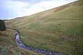 Oberlauf des Water of Ken
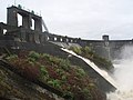 Damm des Earltouns Loch


Bauwerke
Mit der Ken Bridge überspannt nahe New Galloway eine als Kategorie-A-Denkmal geschützte Brücke den Fluss. Die fünfbögige Steinbrücke entstand 1824 nach einem Entwurf des bedeutenden schottischen Bauingenieurs John Rennie.[3] Das im späten 16. oder frühen 17. Jahrhundert erbaute Tower House Earlstoun Castle befindet sich am linken Ken-Ufer nahe St John’s Town of Dalry.[4]
Weblinks
Einzelnachweise
- Ken in: F. H. Groome: Ordnance Gazetteer of Scotland: A Survey of Scottish Topography, Statistical, Biographical and Historical., Grange Publishing, Edinburgh, 1885.
- Eintrag im Gazetteer for Scotland
- Listed Building – Eintrag. In: Historic Scotland.
- Listed Building – Eintrag. In: Historic Scotland.
На других языках
- [de] Water of Ken
[en] Water of Ken
The Water of Ken is a river in the historical county of Kirkcudbrightshire in Galloway, south-west Scotland. It rises on Blacklorg Hill, north-east of Cairnsmore of Carsphairn in the Carsphairn hills, and flows south-westward into The Glenkens, passing through Kendoon, Carsfad and Earlstoun lochs, all of which are dammed to supply the Galloway Hydro Electric Scheme. At Kendoon Dam the Ken is joined by a major tributary the Water of Deugh. From there, the river flows south, passing St. John's Town of Dalry and New Galloway, before widening to form the 9-mile long Loch Ken. The Black Water of Dee also enters halfway down the loch, and from Glenlochar, at the south end of the loch, the river continues as the Dee towards Kirkcudbright and the coast. There are a number of interesting bridges over the Water of Ken. Smeaton's Bridge[1] (Sometimes Smitton's Bridge) carries the B729 road which runs between Carsphairn and Moniaive. It crosses the Ken a half mile above the confluence of the Stroanfreggan burn. This bridge has a single arch 42 ft long.[2] A few miles further downstream the High Bridge of Ken spans the river at a narrow ravine on the B7000 back road from Carsphairn to St John's Town of Dalry. The bridge has 2 arches each 24 ft long. British listed buildings website describes the bridge as early 18th century, possibly earlier origin.[3] Further downstream again the Ken Bridge lies between St John's Town of Dalry and New Galloway.This bridge carries the A712 road and dates from 1822. It has 5 granite arches and is 340 ft long.[4] Immediately adjacent to the bridge is the Ken Bridge Hotel.Другой контент может иметь иную лицензию. Перед использованием материалов сайта WikiSort.org внимательно изучите правила лицензирования конкретных элементов наполнения сайта.
WikiSort.org - проект по пересортировке и дополнению контента Википедии