geo.wikisort.org - Fluss
Das Wadi Djedi ist ein regelmäßig austrocknender Fluss, ein Wadi, in Nordafrika mit einer Länge von etwa 480 Kilometern. Er fließt nur im Norden von Algerien entlang der Südgrenze des Atlasgebirges.
| Wadi Djedi Oued Mzi (Oberlauf) | ||
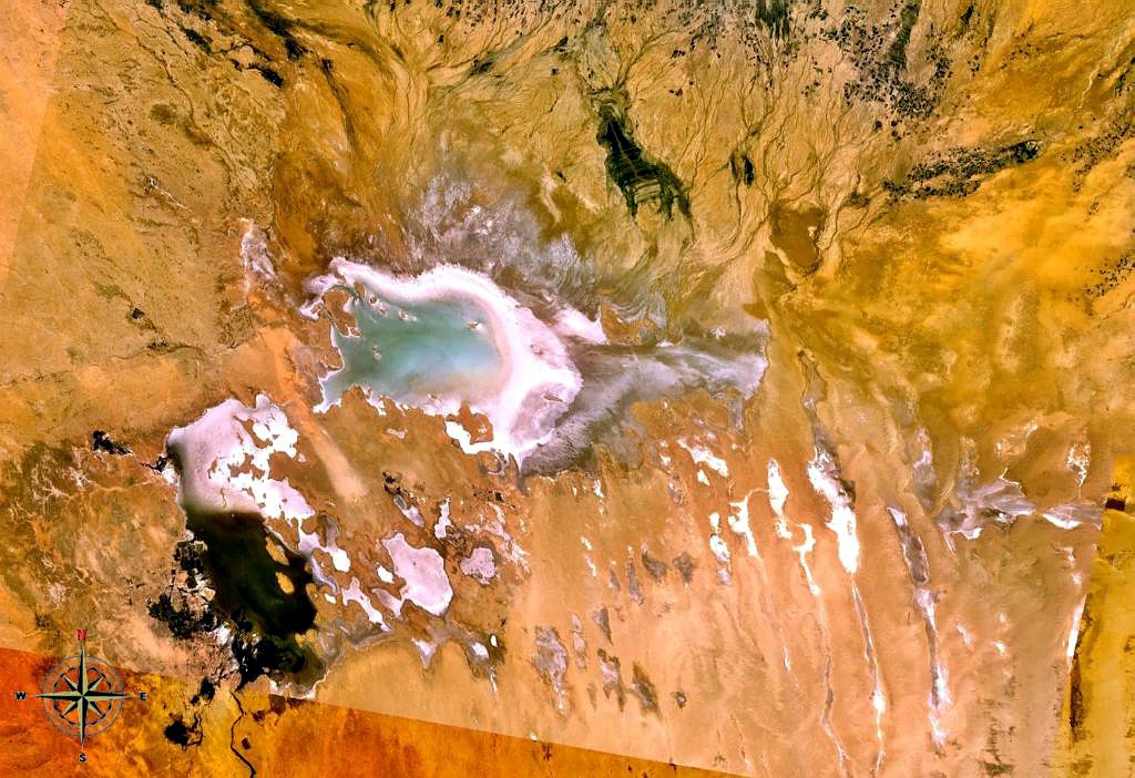 Satellitenbild Mündung Schott Melghir | ||
| Daten | ||
| Lage | ||
| Quelle | Saharaatlas 33° 59′ 24″ N, 2° 1′ 19″ O | |
| Quellhöhe | 1402 m[1] | |
| Mündung | Schott Melghir 34° 19′ 51″ N, 6° 8′ 6″ O | |
| Mündungshöhe | 39,6 m unter dem Meeresspiegel[1] | |
| Höhenunterschied | 1.441,6 m | |
| Sohlgefälle | 3 ‰ | |
| Länge | 479,6 km[1] | |
| Einzugsgebiet | 24.200 km²[2] | |
| Linke Nebenflüsse | Oued el Hamar, Oued Mergueb, Oued el Abiad, Oued Ouzzen | |
| Rechte Nebenflüsse | Oued Messad | |
Verlauf
Er hat seine Quellen im Saharaatlas. Er entsteht aus dem Zusammenfluss der Oued Mzi, seinem eigentlichen Quellfluss, und Messad, die sich östlich der Stadt Laghouat vereinigen. Verschiedentlich wird der Oued Mzi als Nebenname bzw. Oberlauf des Wadi Djedi genommen. Nur so ergibt sich die Quellhöhe von 1402 m und die Länge von 479,6 Kilometer.[1] Die Quelle ist 81 Kilometer westlich von Laghouat am Djebel Amour[3] zu finden, dessen Gipfelhöhe mit 1593 m angegeben ist.[2] Im Quellgebiet liegt die Siedlung Ain Fourene. Der Fluss fließt ostwärts in Richtung der Grenze zu Tunesien. Kurz bevor er diese erreicht, mündet er in den Schott Melghir (ein Schott ist ein See, der ebenfalls einen im Laufe des Jahres extrem schwankenden Wasserspiegel aufweist).
Einzelnachweise
- UNIDO – World Small Hydropower Development Report 2019 Basisdaten des Wadi Djedi Seite 122 der PDF-Datei 11,3 MB
- Hydrologie et Hydrogeologie du Bassin Versant de L’oued M’zi (Laghouat, Algerie) Réseau hydrographique, le bassin versant de l’oued Djedi auf Seite 69 der PDF-Datei 10,3 MB
- Djebel Amour bei Geonames
На других языках
- [de] Wadi Djedi
[en] Djedi River
Djedi River, also called Djeddi River, Oued Djedi or Ouad-ed-Djedi (Arabic: وادي الجدي Wādī al-Jadī) is a wadi (river with intermittent stream) in Algeria and one of the largest rivers of Sahara. It starts in the Saharan Atlas mountains, at elevation of about 1,400 meters (4,600 ft), flows for about 480 kilometers (300 mi) approximately from west to east, and discharges into Chott Melrhir lake at about –40 meters (130 ft) below mean sea level, which is the lowest point of Algeria.[1] It is fed by rains and melting snow and has a permanent flow only in its upper part. The river rises on the southern slopes of Djebel Amour, near the town of Aflou, and feeds several date palm groves, such as the Laghouat oasis, which largely depend on this supply; water is also taken from numerous wells dug near the river.[2] During the rain season in winter, the river helps to rise the water level of Chott Melrhir, and in summer, the lake and lower reaches of the river dry out.[3][4] The river is up to several kilometers wide, but its banks are rarely covered with water. The river bed mostly consists of gypsum and mud and bears traces of erosion associated with the large variations of the flow. Although the soil in and around the river appears arable, it is barren due to the high concentration of salt. For the same reason, the soil absorbs much condensation overnight that keeps it partly humid during much of the day.[5][ru] Джеди
Река Джеди[1] (фр. Oued Djedi) — вади в Алжире, входит в число крупных рек Сахары, имеет протяжённость около 480 км.Другой контент может иметь иную лицензию. Перед использованием материалов сайта WikiSort.org внимательно изучите правила лицензирования конкретных элементов наполнения сайта.
WikiSort.org - проект по пересортировке и дополнению контента Википедии