geo.wikisort.org - Fluss
Der Uaso-Nyiro-Fluss ist ein Fluss in Kenia.
| Uaso Nyiro Ewaso Ng'iro oder Lagh Dera | ||
 Der Uaso Nyiro im Shaba-Nationalreservat | ||
| Daten | ||
| Lage | bei Hochwasser bis | |
| Flusssystem | Juba | |
| Abfluss über | Juba → Indischer Ozean | |
| Quelle | im Aberdare Range | |
| Mündung | in den Juba kurz vor dessen Mündung 0° 0′ 36″ S, 42° 35′ 53″ O | |
| Mündungshöhe | 6 m
| |
| Einzugsgebiet | 231.000 km²[1] | |
| Linke Nebenflüsse | Milgis, Lag Bogal | |
| Rechte Nebenflüsse | Kutulo | |
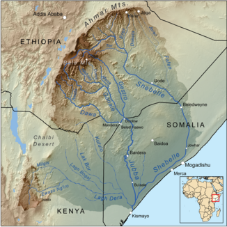 Einzugsgebiet des Juba mit dem Uaso Nyiro links | ||
Geografie
Der Fluss entspringt in der Aberdare Range. Von dort fließt er in nördliche Richtung. Bei dem Ort Nyahururu befinden sich die 72 Meter hohen Thomson-Wasserfälle, über die er stürzt. Von dort macht er einen weiten Bogen nach Osten über Archers Post, um nach den Chanler’s Falls in die Lorian Swamp zu fließen. Nach dem Verlassen der Sümpfe kennt man ihn unter dem Namen Lagh Dera.[2] Er fließt weiter in östliche Richtung, bis er sich schließlich mit dem Juba kurz vor dessen Mündung vereinigt.
Einzugsgebiet
Das Einzugsgebiet des Lagh Dera umfasst mit Anteilig etwa 200.000 km² ein Drittel der Landesfläche Kenias. Allerdings trägt es nur einen geringen Teil zum Abfluss bei. Er erreicht nur selten überhaupt Somalia, und nur bei Hochwasser.[3]
Nationalparks
Der Fluss ist die Lebensader des 165 Quadratkilometer großen Samburu National Reserve und weiterer Nationalparks in Kenia, darunter das Shaba-Nationalreservat und das Buffalo-Springs-Nationalreservat. Am Fluss leben zahlreiche Tiere und es gibt zahlreiche Krokodile im Fluss.
Einzelnachweise
- Managing shared river basins in the Horn of Africa: Ethiopian planned water projects on the Juba and Shabelle rivers and effects on downstream uses in Somalia
- IWMI Global Wetland Initiative: Kenya (Memento vom 17. Juli 2010 im Internet Archive) (PDF; 232 kB) Seite 11
- CH. LEIBUNDGUT; Institute of Geography, Department of Hydrology, University of Berne, Berne, Switzerland: Runoff regime of a tropical high mountain region (PDF; 788 kB) Seite 314
На других языках
- [de] Uaso Nyiro
[en] Ewaso Ng'iro
Ewaso Ng'iro is a river in Kenya which rises on the west side of Mount Kenya and flows north then east and finally south-east, passing through Somalia where it joins the Jubba River.[1] The upper basin of the Ewaso Ng'iro River is 15,200-square-kilometre (5,900 sq mi).[2] The river has a continuous water supply due to the glaciers on Mount Kenya. Ewaso Ng'iro feeds into Lake Ol Bolossat, the only lake in Nyandarua county and the larger Central Kenya.[3][4][5] Ewaso Ng'iro crosses seven arid to semi-arid landscapes. It is characterized by vastly different physiographic features and species and has become a fundamental component to the survival of the wildlife, as well as the expansion of human population and socio-economic developments. Water, the limited land resource provided by the Ewaso Ng’iro watershed is unevenly distributed throughout the higher and lower regions of the catchment due to the large percentage necessary to maintain agricultural practices and climatic changes (Mutiga, Su, and Woldai 3).[es] Río Lagh Dera
El río Lagh Dera (Ewaso Ng'iro en su parte alta) es un río en Kenia que nace en la vertiente occidental del monte Kenia y fluye hacia el norte, y luego al este y finalmente al sur-este, adentrándose en Somalia, donde se une con el río Jubba. A Somalia solamente llega en época de aguas altas, ya que el resto del año su cauce se seca. Drena una amplia cuenca de 231.000 km².[1][ru] Эвасо-Нгиро (приток Джуббы)
Эва́со-Нги́ро[1][2] (Ва́со-Ньи́ро[3][4][5], англ. Ewaso Ng'iro[6]) — река в Кении[1]. Длина около 300 км, третья по протяжённости кенийская река, площадь бассейна — 55 000 км²[7].Другой контент может иметь иную лицензию. Перед использованием материалов сайта WikiSort.org внимательно изучите правила лицензирования конкретных элементов наполнения сайта.
WikiSort.org - проект по пересортировке и дополнению контента Википедии