geo.wikisort.org - Fluss
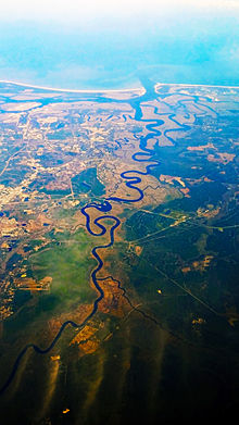
Der St. Marys River ist ein Fluss in den Vereinigten Staaten. Von seiner Quelle, dem Okefenokee-Sumpf, bis zur Mündung in den Atlantischen Ozean markiert er die Grenze zwischen den Bundesstaaten Florida und Georgia. Er ist 203 km lang.
| St. Marys River | ||
 | ||
| Daten | ||
| Gewässerkennzahl | US: 306327 | |
| Lage | Grenze Florida/Georgia, USA | |
| Flusssystem | St. Marys River (Florida/Georgia) | |
| Quelle | Okefenokee-Sumpf 30° 25′ 24″ N, 82° 12′ 32″ W | |
| Mündung | in den Atlantik 30° 43′ 22″ N, 81° 30′ 6″ W | |
Kurz vor der Mündung des Flusses liegt am linken Ufer die namensgebende Stadt St. Marys. Von hier besteht eine Fähranbindung auf die der Küste vorgelagerten Insel Cumberland Island.

Weblinks
Commons: St. Marys River – Sammlung von Bildern, Videos und Audiodateien
На других языках
- [de] St. Marys River (Florida/Georgia)
[en] St. Marys River (Florida–Georgia)
The St. Marys River (named Saint Marys River by the United States Geological Survey,[1]) is a 126-mile-long (203 km)[2] river in the southeastern United States. The river was known to the Indians of the area as Thlathlothlaguphka,[3] or Phlaphlagaphgaw,[4] meaning "rotten fish".[5] French explorer Jean Ribault named the river the Seine when he encountered it in 1562.[6][7] From near its source in the Okefenokee Swamp, to its mouth at the Atlantic Ocean, it forms a portion of the border between the U.S. states of Georgia and Florida. The river also serves as the southernmost point in the state of Georgia. The St. Marys River rises as a tiny stream, River Styx, flowing from the western edge of Trail Ridge, the geological relic of a barrier island/dune system, and into the southeastern Okefenokee Swamp. Arching to the northwest, it loses its channel within the swamp, then turns back to the southwest and reforms a stream, at which point it becomes the St. Marys River. Joined by another stream, Moccasin Creek, the river emerges from the Okefenokee Swamp at Baxter, Florida/Moniac, Georgia. It then flows south, then east, then north, then east-southeast, finally emptying its waters into the Atlantic, near St. Marys, Georgia and Fernandina Beach, Florida.[es] Río Santa María (Florida)
El río Santa María o Santamaría[1] (nombrado Saint Marys River por la USGS)[2] es un río de 203 km en el sureste de los Estados Unidos. Se nombró en honor a la santa católica Santa María. Actualmente es parte del límite entre los estados de Georgia y Florida. Históricamente, fue el límite norte entre la Florida española y los Estados Unidos de América.[3]Текст в блоке "Читать" взят с сайта "Википедия" и доступен по лицензии Creative Commons Attribution-ShareAlike; в отдельных случаях могут действовать дополнительные условия.
Другой контент может иметь иную лицензию. Перед использованием материалов сайта WikiSort.org внимательно изучите правила лицензирования конкретных элементов наполнения сайта.
Другой контент может иметь иную лицензию. Перед использованием материалов сайта WikiSort.org внимательно изучите правила лицензирования конкретных элементов наполнения сайта.
2019-2025
WikiSort.org - проект по пересортировке и дополнению контента Википедии
WikiSort.org - проект по пересортировке и дополнению контента Википедии