geo.wikisort.org - Fluss
Der Monkey River ist ein rund 60 Kilometer langer Fluss im mittelamerikanischen Belize.
| Monkey River | ||
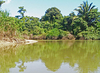
 unterer Teil des Monkey Rivers Ästuar | ||
| Daten | ||
| Lage | Toledo District, Belize | |
| Flusssystem | Monkey River | |
| Quelle | in den Maya Mountains 16° 30′ 8″ N, 88° 51′ 47″ W | |
| Mündung | in Monkey River Town in den Golf von Honduras (Karibik) 16° 21′ 54″ N, 88° 29′ 3″ W
| |
| Länge | ca. 60 km | |
Er entspringt in den Maya Mountains in der Provinz Toledo nahe der Grenze zu Guatemala und fließt ostwärts Richtung Karibisches Meer und mündet bei Monkey River Town in den Golf von Honduras. Der Monkey River hat große Bedeutung für das nachgelagerte Belize Barrier Reef, indem viele Fische und andere Lebewesen vom vermischten Meereswasser mit dem klaren Wasser des Flusses profitieren[1].
In der Nähe des Monkey Rivers befinden sich die Mayaruinen Lubaantun und Nim Li Punit, am Unterlauf durchfließt der Fluss den Payne's Creek National Park.
Weblinks
Commons: Monkey River – Sammlung von Bildern, Videos und Audiodateien
Einzelnachweise
- — (Memento des Originals vom 30. September 2007 im Internet Archive) Info: Der Archivlink wurde automatisch eingesetzt und noch nicht geprüft. Bitte prüfe Original- und Archivlink gemäß Anleitung und entferne dann diesen Hinweis.
На других языках
- [de] Monkey River
[en] Monkey River
Monkey River is a coastal watercourse in southern Belize that rises in the Maya Mountains and discharges to the Caribbean Sea near Monkey River Town. One of Belize's major rivers, Monkey River has northern headwaters which originate in the Cockscomb Basin Wildlife Sanctuary, where the Swasey Branch drains the East Basin of that wildlife sanctuary. Further south, the Bladen Branch watercourse drains the eastern slopes of the Maya Mountains including the ancient Mayan settlement areas of Lubaantun and Nim Li Punit. These two watercourses join to form the Monkey River approximately 16 kilometres upstream from the mouth of the Monkey River. The Monkey River is readily navigated throughout the year using small boats, but navigation above the major confluence (of Bladen and Swasey Branches) becomes more difficult due to lack of depth when the dry season starts about February. Habitats in this watershed provide cover for such diverse species as the ocelot, jaguar, Guatemalan black howler, bare-throated tiger heron, Morelet's crocodile, fer-de-lance and manatee.Текст в блоке "Читать" взят с сайта "Википедия" и доступен по лицензии Creative Commons Attribution-ShareAlike; в отдельных случаях могут действовать дополнительные условия.
Другой контент может иметь иную лицензию. Перед использованием материалов сайта WikiSort.org внимательно изучите правила лицензирования конкретных элементов наполнения сайта.
Другой контент может иметь иную лицензию. Перед использованием материалов сайта WikiSort.org внимательно изучите правила лицензирования конкретных элементов наполнения сайта.
2019-2025
WikiSort.org - проект по пересортировке и дополнению контента Википедии
WikiSort.org - проект по пересортировке и дополнению контента Википедии