geo.wikisort.org - Fluss
Der Liao He, Liao-Fluss, Liauho usw. (chinesisch 遼河 / 辽河, Pinyin Liáo Hé, W.-G. Liao Ho, englisch Liao River) ist mit 1390 km Länge der größte Fluss im südlichen Nordostchina (Mandschurei).
| Liao He 辽河 | ||
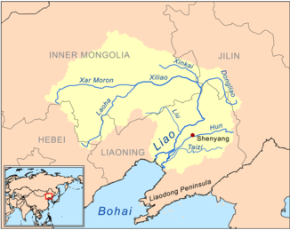 Das Flusssystem des Liao He | ||
| Daten | ||
| Lage | Liaoning (VR China) | |
| Flusssystem | Liao He | |
| Zusammenfluss von | Xiliao He und Dongliao He nahe der Großgemeinde Guyushu 42° 58′ 53″ N, 123° 32′ 50″ O | |
| Mündung | in Yingkou in die Liaodong-Bucht des Golfs von Bohai 40° 54′ 42″ N, 121° 48′ 42″ O | |
| Mündungshöhe | 0 m
| |
| Länge | 1390 km | |
| Linke Nebenflüsse | Hun He, Taizi He | |
| Rechte Nebenflüsse | Liu He (Liao He) | |
Die Namen der Provinz Liaoning und der Liaodong-Halbinsel leiten sich von ihm ab. Der Liao He entsteht durch Vereinigung der Flüsse Xiliao He (西遼河 / 西辽河, Xīliáo Hé – „Westlicher Liao-Fluss“) und Dongliao He (東遼河 / 东辽河, Dōngliáo Hé – „Östlicher Liao-Fluss“).
Der östliche Dongliao He entspringt im Hügelland Jilin Hada Ling (吉林哈達嶺 / 吉林哈达岭, Jílín Hādá Lǐng) im Kreis Dongliao der Provinz Jilin. Der westliche Xiliao He entsteht wiederum durch Vereinigung des nördlicher fließenden Xar Moron He (西拉木倫河 / 西拉木伦河, Xīlā Mùlún Hé) und des Laoha He (老哈河, Lǎohā Hé) aus südlicher Richtung. Ein späterer Nebenfluss des Xiliao He ist der Xinkai He (新開河 / 新开河, Xīnkāi Hé).
Der Xar Moron He entspringt im Gebirge Baicha Shan (白岔山, Báichà Shān) im Südwesten des Hexigten-Banners in der südöstlichen Inneren Mongolei. Der Laoha He entspringt im Guangtou Shan (光頭山 / 光头山, Guāngtóu Shān) des Kreises Pingquan in der Provinz Hebei.
Die beiden Flüsse vereinen sich nahe dem Gebiet der Großgemeinde Guyushu (古榆树镇, Gǔyúshù zhèn) des Kreises Changtu in Liaoning, und ab dort fließt der Fluss unter dem Namen Liao He durch die große Liaohe-Ebene in die Liaodong-Bucht (Liaodong Wan) des Golfes von Bohai (Bo Hai).
1958 änderte der Fluss seinen Lauf.
Siehe auch
Literatur
- Cihai. Shanghai cishu chubanshe, Shanghai 2002, ISBN 7-5326-0839-5
На других языках
- [de] Liao He
[en] Liao River
The Liao River (simplified Chinese: 辽河; traditional Chinese: 遼河; pinyin: Liáo Hé) is the principal river in southern Northeast China, and one of the seven main river systems in China. Its name derived from the Liao region, a historical name for southern Manchuria, from which the Liaoning province, Liaodong Peninsula and Liao dynasty also all have derived their names.[1] The river is also popularly known as the "mother river" in Northeast China.[2] Coursing 1,345 kilometres (836 mi) long, the Liao River system drains a catchment basin of over 232,000 square kilometres (90,000 sq mi), but its mean discharge is quite small at only about 500 cubic metres per second (18,000 cu ft/s), about one-twentieth that of the Pearl River. The Liao River has an exceedingly high sediment load because many parts of it flow through powdery loess.[es] Río Liao
El río Liao (en chino tradicional, 遼河; en chino simplificado, 辽河; pinyin, Liáo hé) es un largo río de China. Con 1345 km, se trata del principal curso de agua del sur de Manchuria.[it] Liao (fiume)
Il Liao (遼河T, 辽河S, Liáo HéP) è il principale fiume nel sud della Manciuria (Cina) e sfocia nel Mare di Bohai.[ru] Ляохэ
Ляохэ́ (кит. трад. 遼河, упр. 辽河, пиньинь Liáohé) — крупнейшая река в южной Маньчжурии.Другой контент может иметь иную лицензию. Перед использованием материалов сайта WikiSort.org внимательно изучите правила лицензирования конкретных элементов наполнения сайта.
WikiSort.org - проект по пересортировке и дополнению контента Википедии