geo.wikisort.org - Fluss
Der Illinois River ist ein 120 km langer Nebenfluss des Rogue River.
| Illinois River | ||
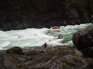
 Rafting durch die Green Wall Rapids am Illinois River | ||
| Daten | ||
| Gewässerkennzahl | US: 1143993 | |
| Lage | Oregon (USA) | |
| Flusssystem | Rogue River | |
| Abfluss über | Rogue River → Pazifischer Ozean | |
| Zusammenfluss von | East Fork und West Fork Illinois River 42° 9′ 35″ N, 123° 39′ 33″ W | |
| Quellhöhe | 387 m[1] | |
| Mündung | in den Rogue River 42° 33′ 0″ N, 124° 3′ 58″ W | |
| Mündungshöhe | 32 m[2] | |
| Höhenunterschied | 355 m | |
| Sohlgefälle | 3 ‰ | |
| Länge | 120 km | |
| Einzugsgebiet | 2546 km² | |
| Abfluss am Pegel bei Kerby Lage: 81 km oberhalb der Mündung |
MNQ MQ MHQ |
3 m³/s 36 m³/s 2611 m³/s |
| National Wild and Scenic River | ||
| East Fork Illinois River | ||
| Gewässerkennzahl | US: 1141571 | |
| Lage | Oregon (USA) | |
| Flusssystem | Rogue River | |
| Abfluss über | Illinois River → Rogue River → Pazifischer Ozean | |
| Quelle | im Curry County 41° 52′ 58″ N, 123° 36′ 43″ W | |
| Vereinigung mit | West Fork zum Illinois River 42° 9′ 35″ N, 123° 39′ 33″ W | |
| Mündungshöhe | 387 m[1]
| |
| West Fork Illinois River | ||
 West Fork of the Illinois River, südlich von O'Brien, Oregon | ||
| Daten | ||
| Gewässerkennzahl | US: 1152083 | |
| Lage | Oregon (USA) | |
| Flusssystem | Rogue River | |
| Abfluss über | Illinois River → Rogue River → Pazifischer Ozean | |
| Quelle | im Curry County 41° 59′ 28″ N, 123° 45′ 52″ W | |
| Vereinigung mit | East Fork zum Illinois River 42° 9′ 35″ N, 123° 39′ 33″ W | |
| Mündungshöhe | 387 m[3]
| |
Der Fluss entspringt in zwei Armen, East Fork Illinois River und West Fork Illinois River, in den Siskiyou Mountains in Nordkalifornien, unmittelbar an der Grenze zu Oregon bevor sie sich bei Cave Junction im Josephine County, Oregon vereinen. Er mündet in den Rogue River. Der Illinois River fließt in überwiegend nordwestlicher Richtung entlang der Westflanke der Klamath Mountains. Beide Quellarme und der Illinois River verlaufen weit überwiegend im Rogue River – Siskiyou National Forest.
80 km der Flussstrecke sind als National Wild and Scenic River ausgezeichnet.[4]
Weblinks
Einzelnachweise
- East Fork Illinois River im Geographic Names Information System des United States Geological Survey
- Illinois River im Geographic Names Information System des United States Geological Survey
- West Fork Illinois River im Geographic Names Information System des United States Geological Survey
- National Wild & Scenic Rivers - Illinois River
На других языках
- [de] Illinois River (Rogue River)
[en] Illinois River (Oregon)
The Illinois River is a tributary, about 56 miles (90 km) long, of the Rogue River in the U.S. state of Oregon. It drains part of the Klamath Mountains in northern California and southwestern Oregon. The river's main stem begins at the confluence of its east and west forks near Cave Junction in southern Josephine County. Its drainage basin includes Sucker Creek, which rises in the Red Buttes Wilderness, near Whiskey Peak on the California state line. The main stem flows generally northwest in a winding course past Kerby and through the Siskiyou National Forest and Kalmiopsis Wilderness. It joins the Rogue River from the south at Agness on the Curry–Josephine county line, 27 miles (43 km) from the Pacific Ocean.Другой контент может иметь иную лицензию. Перед использованием материалов сайта WikiSort.org внимательно изучите правила лицензирования конкретных элементов наполнения сайта.
WikiSort.org - проект по пересортировке и дополнению контента Википедии