geo.wikisort.org - Fluss
Der Cape Fear River ist ein 325 km langer[1] Schwarzwasserfluss im zentralen Osten von North Carolina in den Vereinigten Staaten. Er mündet am Cape Fear in den Atlantischen Ozean, was dem Fluss seinen Namen gibt. Notropis mekistocholas (englisch Cape Fear Shiner) ist eine endemische Fischart seines Einzugsgebietes.
| Cape Fear River | ||
 Einzugsgebiet des Cape Fear Rivers | ||
| Daten | ||
| Lage | North Carolina, Vereinigte Staaten | |
| Flusssystem | Cape Fear River | |
| Mündung | Atlantischer Ozean 33° 53′ 8″ N, 78° 0′ 46″ W
| |
| Länge | 325 km | |
| Abfluss | MQ |
110 m³/s |
| Schiffbar | bis Fayetteville | |
 Der Cape Fear River bei Smith Creek in Wilmington, NC. | ||
Lauf
Der Cape Fear River entsteht in Haywood nahe der Countygrenze zwischen Lee County und Chatham County durch den Zusammenfluss von Deep River und Haw River, direkt unterhalb des B. Everett Jordan Lake. Er fließt in südöstlicher Richtung an Lillington, Fayetteville und Elizabethtown vorbei. Etwa 16 km nordwestlich von Wilmington mündet der Black River ein und in Wilmington der Northeast Cape Fear River. Er wendet sich dann nach Süden und mündet als Ästuar in den Atlantischen Ozean, etwa 5 km westlich von Cape Fear.
Während der Kolonialzeit war der Fluss ein Hauptverkehrsweg ins Innere von North Carolina. Heute ist der Fluss durch eine Reihe von Schleusen und Dämmen bis Fayetteville schiffbar. Der Ästuar des Cape Fear Rivers ist Teil des amerikanischen Atlantic Intracoastal Waterway.
In Wilmington liegt das Schlachtschiff USS North Carolina im Fluss, das im Zweiten Weltkrieg im Einsatz war. Es ist in das National Register of Historic Places eingetragen und dient heute als Museumsschiff.
Als im September 2018 der Hurrikan Florence heranzog, wurden alle Bewohner entlang des Flusses aufgerufen, ihre Häuser vorübergehend zu verlassen. Der Hurrikan verursachte meterhohe Überschwemmungen; zahlreiche Menschen starben und hunderttausende Menschen waren tagelang ohne Strom. Nach dem Bruch eines Dammes bei einem Kraftwerk gelangte toxische Kohleasche in den Fluss.[2]
Siehe auch
- Liste der Flüsse in North Carolina
- North Carolina#Gewässer
Weblinks
- Cape Fear River discharge values available since 9/1/1969. In: UNCW Coastal Ocean Research and Monitoring Program: Monitoring Stations. Archiviert vom Original am 5. März 2016 (englisch).
- Lower Cape Fear River Program. University of North Carolina at Wilmington, archiviert vom Original am 26. Februar 2009 (englisch).
- Center for Marine Science: Aquatic Ecology Laboratory. University of North Carolina at Wilmington (englisch).
- Benthic Ecology Laboratory. University of North Carolina at Wilmington (englisch).
- Thomas E. Lankford jr.: Ichthyology and Fish Ecology Laboratory. University of North Carolina at Wilmington (englisch).
Einzelnachweise
- Cape Fear River. In: The Columbia Gazetteer of North America. Columbia University Press, 2000, archiviert vom Original am 1. April 2005; abgerufen am 28. April 2018 (englisch).
- nytimes.com 21. September 2018: Florence’s Floodwaters Breach Defenses at Duke Energy Plant, Sending Toxic Coal Ash Into River
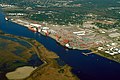 Hafen in Wilmington am Ästuar des Flusses
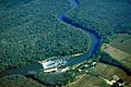 Lock and Dam No. 1 des Cape Fear Rivers im Bladen County
 Ein Frachtschiff befährt die Flussmündung bei Southport
 Frachtschiff bei Southport


На других языках
- [de] Cape Fear River
[en] Cape Fear River
The Cape Fear River is a 191.08-mile (307.51 km) long[5] blackwater river in east central North Carolina. It flows into the Atlantic Ocean near Cape Fear, from which it takes its name. The river is formed at the confluence of the Haw River and the Deep River (North Carolina) in the town of Moncure, North Carolina. The river also has several pollutants, ranging from suspended solids and runoff to manmade chemicals like PFAS including GenX, Perfluorooctanesulfonic acid (PFOS), Perfluorooctanoic acid (PFOA), and byproducts of production of the fluoropolymer Nafion and intermediates used in the production of other Fluoropolymers (e.g. PPVE, PEVE and PMVE Perfluoroether). Additionally other industrial analytes have been demonstrated to be in the Haw river (a tributary to the Cape Fear drainage) such as 1,4-Dioxane. Additional assessments of drinking water associated with the Haw River has been shown to be contaminated with other pollutants. https://chapelboro.com/town-square/nationwide-study-finds-pittsboros-drinking-water-among-worst-in-u-s[it] Cape Fear (fiume)
Il Cape Fear è un fiume lungo 307,5 km[1] della Carolina del Nord centro-orientale. Sfocia nell'oceano Atlantico vicino al promontorio di Cape Fear, da cui prende il nome. Il fiume si forma alla confluenza del fiume Haw e del fiume Deep nella città di Moncure. Si tratta di un corso d'acqua che trasporta diversi inquinanti, che vanno da solidi sospesi a prodotti chimici artificiali come PFAS tra cui GenX, acido perfluoroottansolfonico (PFOS), acido perfluoroottanoico (PFOA) e sottoprodotti della produzione del fluoropolimero Nafion e intermedi utilizzati nella produzione di altri fluoropolimeri (per esempio Perfluoroetere PPVE, PEVE e PMVE). Inoltre, è stato dimostrato che altri residui industriali sono presenti nel fiume Haw (un affluente del drenaggio di Cape Fear) come l'1,4-Diossano. È stato dimostrato, da valutazioni delle acque potabili associate al fiume Haw, che sono contaminate da altri inquinanti.[2][ru] Кейп-Фир (река)
Кейп-Фир (англ. Cape Fear River) — река на востоке США в Северной Каролине, впадающая в Атлантический океан в бухте мыса Страха, по которому и получила своё название. Длина реки составляет 325 км[1]. Вода реки характерного тёмного цвета в связи с тем, что протекает в основном по лесной местности.Другой контент может иметь иную лицензию. Перед использованием материалов сайта WikiSort.org внимательно изучите правила лицензирования конкретных элементов наполнения сайта.
WikiSort.org - проект по пересортировке и дополнению контента Википедии