geo.wikisort.org - Bacino
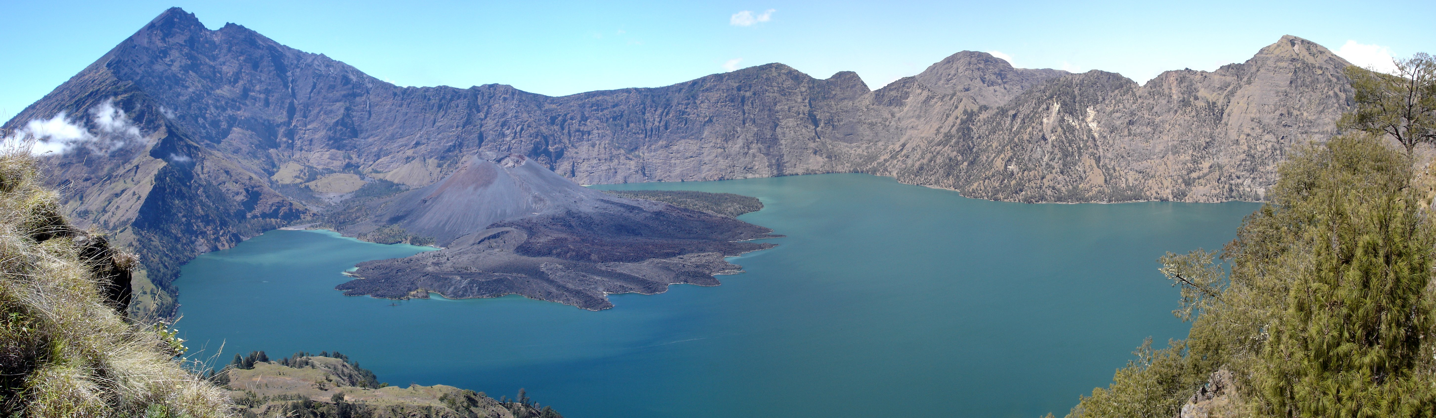
Segara Anak è un lago di origine vulcanica contenuto nel cratere del Monte Rinjani sull'isola di Lombok in Indonesia.
| Segara Anak | |
|---|---|
 | |
| Stato | |
| Coordinate | 8°24′59.76″S 116°27′59.76″E |
| Altitudine | 2 008 m s.l.m. |
| Dimensioni | |
| Superficie | 11,3 km² |
| Profondità massima | 190 m |
| Idrografia | |
| Origine | lago di origine vulcanica |
 Segara Anak | |
Il nome Segara Anak significa figlio del mare a causa del suo colore blu che ricorda il mare. Tale lago si formo in seguito alla violentissima eruzione del Samalas del 1257.
Altri progetti
 Wikimedia Commons contiene immagini o altri file su Segara Anak
На других языках
[en] Lake Segara Anak
Segara Anak is a crater lake in the caldera that formed during the explosive volcanic eruption of Mount Samalas in 1257. The caldera is next to Mount Rinjani on Lombok Island in Indonesia. "Segara Anak" means "child of the sea" and refers to the blue lake's resemblance to the sea. The volcanic cone Gunung Barujari is at the eastern end of the lake and is responsible for its crescent shape. The lake temperature is 20–22 °C (68–72 °F), which is 5-7 °C (9-13 °F) higher than normal for a lake at its altitude. Hot magma below the lake is responsible for this anomaly. Gas bubbles escape from the lake floor, helping the lake to have a pH of 7-8.[1][fr] Lac Segara Anak
Le lac Segara Anak, en indonésien Danau Segara Anak, littéralement « mer enfant », c'est-à-dire « petite mer », est un lac de cratère d'Indonésie situé dans la caldeira Segara Anak, au pied du mont Rinjani, dans la province des Petites îles de la Sonde occidentales, sur l'île de Lombok.- [it] Segara Anak
Текст в блоке "Читать" взят с сайта "Википедия" и доступен по лицензии Creative Commons Attribution-ShareAlike; в отдельных случаях могут действовать дополнительные условия.
Другой контент может иметь иную лицензию. Перед использованием материалов сайта WikiSort.org внимательно изучите правила лицензирования конкретных элементов наполнения сайта.
Другой контент может иметь иную лицензию. Перед использованием материалов сайта WikiSort.org внимательно изучите правила лицензирования конкретных элементов наполнения сайта.
2019-2026
WikiSort.org - проект по пересортировке и дополнению контента Википедии
WikiSort.org - проект по пересортировке и дополнению контента Википедии