geo.wikisort.org - Bacino
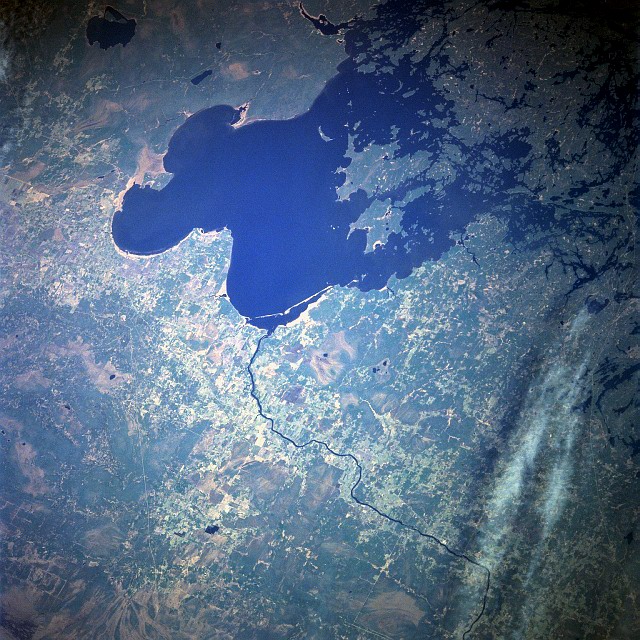
Il lago dei Boschi (Lake of the Woods) è un lago del Nord America, situato al confine delle province canadesi dell'Ontario e del Manitoba e lo Stato del Minnesota negli Stati Uniti.
| Lago dei Boschi | |
|---|---|
 | |
| Stati | |
| Regioni | Manitoba, Ontario, Minnesota |
| Coordinate | 49°09′00″N 94°49′59.99″W |
| Altitudine | 322 m s.l.m. |
| Dimensioni | |
| Superficie | 4.350 km² |
| Lunghezza | 110 km |
| Larghezza | 95 km |
| Profondità massima | 49 m |
 | |
Ha una superficie di 4.350 km² e contiene 14.552 isole che generano il fronte di coste più vasto fra tutti i laghi canadesi: ben 105.000 km di lunghezza complessiva.
Il principale immissario è il fiume Winnipeg[emissario o immissario?] che si dirige verso il lago Winnipeg; il suo principale emissario è il fiume Rainy, che si dirige verso il Lago Superiore.
Sul lago dei Boschi si affaccia il cosiddetto Angolo di nord-ovest, penisola in territorio degli Stati Uniti ma raggiungibile via terra solo dal Canada che costituisce il punto più settentrionale degli Stati Uniti Continentali, escludendo dunque l'Alaska, nonché l'unico territorio degli Stati Uniti Continentali ad essere situato sopra il 49' parallelo nord.
La superficie del lago ghiaccia completamente da circa metà dicembre a circa metà aprile, con uno spessore che arriva a 50–80 cm ed oltre, sufficiente a permettere il passaggio di automobili e spesso anche di autocarri.[1]
Principali centri abitati lungo le sue rive
Nel Minnesota:
- Angle Inlet (Minnesota)
- Baudette (Minnesota)
- Warroad (Minnesota)
Nell'Ontario:
- French Portage Narrows (Ontario)
- Keewatin (Ontario)
- Kenora (Ontario)
- Minaki (Ontario)
- Rainy River (Ontario)
- Sioux Narrows (Ontario)
Nel Manitoba:
- Middlebro (Manitoba)
Note
- (EN) General ice thickness guidelines, su Minnesota Department of Natural Resources. URL consultato il 24 luglio 2021.
Altri progetti
 Wikimedia Commons contiene immagini o altri file su lago dei Boschi
Collegamenti esterni
- (EN) Lago dei Boschi, su Enciclopedia Britannica, Encyclopædia Britannica, Inc.
- (EN) Lago dei Boschi, su Geographic Names Information System, USGS.
| Controllo di autorità | VIAF (EN) 157284006 · LCCN (EN) n98032604 · GND (DE) 4385885-5 · J9U (EN, HE) 987007535735105171 (topic) |
|---|
На других языках
[de] Lake of the Woods
Der Lake of the Woods (französisch Lac des Bois) ist ein See in den kanadischen Provinzen Manitoba und Ontario und im US-Bundesstaat Minnesota. Das 1925 von Kanada und den Vereinigten Staaten unterzeichnete Lake of the Woods Convention and Protocol regelt den Grenzverlauf. Dabei entstand das Northwest Angle genannte Gebiet, das auf dem Landweg vom Rest der USA nicht zu erreichen ist.[en] Lake of the Woods
Lake of the Woods (French: lac des Bois) is a lake occupying parts of the Canadian provinces Ontario and Manitoba along with the U.S. state of Minnesota.[3] Lake of the Woods is over 70 miles (110 km) long and wide, containing more than 14,552 islands and 65,000 miles (105,000 km) of shoreline. It is fed by the Rainy River, Shoal Lake, Kakagi Lake and other smaller rivers. The lake drains into the Winnipeg River and then into Lake Winnipeg. Ultimately, its outflow goes north through the Nelson River to Hudson Bay.[es] Lago de los Bosques
El lago de los Bosques (en inglés: Lake of the Woods), en francés, Lac des Bois, es un lago que ocupa parte de la superficie de las provincias canadienses de Manitoba y Ontario, y el estado de Minnesota, en los Estados Unidos. Separa una porción de tierra estadounidense, el Northwest Angle (Ángulo del Noroeste), del resto de los Estados Unidos, de tal forma que sólo se puede llegar a este lugar atravesando el lago o cruzando previamente la frontera canadiense. El Northwest Angle es la parte más septentrional de los Estados Unidos si se exceptúa el estado de Alaska.[fr] Lac des Bois
Le lac des Bois (en anglais : Lake of the Woods) est situé dans les provinces canadiennes de l’Ontario (en jaune sur la carte) et du Manitoba (en rouge) ainsi que dans l’État américain du Minnesota (en vert et violet). Il existe une exclave des États-Unis, l'Angle nord-ouest du Minnesota (en violet), qui ne peut être atteinte qu’en passant par le Canada ou en empruntant les eaux du lac. On y trouve également la zone (l’île Penasse) la plus au nord des États-Unis (hors Alaska).- [it] Lago dei Boschi
[ru] Лесное (озеро, Северная Америка)
Лесное (англ. Lake of the Woods) — озеро в Северной Америке. Находится западнее Великих озёр на границе Канады (провинции Манитоба и Онтарио) и США (штат Миннесота). Занимает 7 место по площади среди озёр США. Воды озера отделяют Миннесоту от Северо-Западного Угла — небольшой территории, примыкающей к Канаде и являющейся самой северной точкой Континентальных штатов.Другой контент может иметь иную лицензию. Перед использованием материалов сайта WikiSort.org внимательно изучите правила лицензирования конкретных элементов наполнения сайта.
WikiSort.org - проект по пересортировке и дополнению контента Википедии