geo.wikisort.org - Bacino
Il lago Čany (in russo: озеро Чаны? o Большие Чаны) è un lago della Russia siberiana situato nella steppa di Barabinsk. Il lago si trova sul territorio di cinque rajon dell'Oblast' di Novosibirsk: Kupinskij, Zdvinskij, Barabinskij, Čanovskij e Čistoozërnyj.
| Lago Čany | |
|---|---|
 | |
| Stato | |
| Circondario federale | Siberia |
| Soggetto federale | |
| Rajon | Kupinskij, Zdvinskij, Barabinskij, Čanovskij, Čistoozërnyj. |
| Coordinate | 54°50′N 77°40′E |
| Altitudine | 106[1] m s.l.m. |
| Dimensioni | |
| Superficie | ~ 2000 km² |
| Lunghezza | 91[1] km |
| Larghezza | 88[1] km |
| Profondità massima | 7 m |
| Profondità media | 2[1] m |
| Volume | 4,3 km³ |
| Idrografia | |
| Bacino idrografico | 29 930 km² |
| Immissari principali | Čulym |
 Lago Čany | |
 | |
Il suo nome deriva dalla parola turca čan che significa "grande nave".[2]
Descrizione
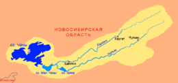
Il lago Čany è più grande lago della Siberia occidentale. Si tratta di un sistema di laghi con aree poco profonde collegati da canali. I tre laghi più grandi sono: Činjaichinskij, Tagano-Kazancevskij e Jarkovskij che differiscono per salinità dell'acqua, area e profondità.
Il lago ha complessivamente una superficie che varia dai 1 400 ai 3 500 km², con una lunghezza totale di 91 km e una larghezza di 88 km; la profondità media è di 2 m.[1] Le rive sono piuttosto basse e fortemente frastagliate, ricoperte di canne, carici e cespugli. Il fondo è sabbioso e limaccioso.[1] L'acqua è leggermente salina, nella parte sud-orientale del lago la salinità è più bassa.
Il lago è alimentato dalle precipitazioni nevose e dal fiume Čulym che sfocia nel lago Malye Čany (Малые Чаны) il quale è collegato al Čany da un canale a sud-est. È gelato, mediamente, dalla seconda metà di ottobre/prima metà di novembre, fino a maggio.[1]
Isole
Ci sono circa 70 isole sul lago, le più grandi sono: Amel'kina Griva, Šul'dikov, Ležan, Medvežij, Kolpačok, Činjaicha, Čerëmuchovyj e Redkij. Molte altre isole (Čeremuškin, Kobylij, Perekopnyj, Bekarev, Kalinova, Činjaicha, Šipjagin, Kruglyj, Kolotov, Kamyšnyj) sono monumenti naturali della regione, poiché hanno conservato paesaggi unici e sono l'habitat di rare specie di piante e animali.[1] Ci sono concentrazioni significative di uccelli acquatici sul lago durante i periodi di migrazione.
Note
- (RU) М.Г. Гречушникова, Чаны, su water-rf.ru. URL consultato il 6 agosto 2020.
- (RU) Топонимический словарь Новосибирской области, su ilia-romantic.narod.ru. URL consultato il 5 agosto 2020.
Altri progetti
 Wikimedia Commons contiene immagini o altri file su lago Čany
Collegamenti esterni
- Mappe: N-43 (JPG), su maps.vlasenko.net. URL consultato il 6 agosto 2020.; N-44 (JPG), su maps.vlasenko.net. URL consultato il 6 agosto 2020. (edizione 1987)
| Controllo di autorità | VIAF (EN) 315149336 |
|---|
На других языках
[de] Tschanysee
Der Tschanysee (russisch Чаны) ist ein abflussloser See in der Barabasteppe im Südosten des Westsibirischen Tieflandes in Russland.[en] Lake Chany
Lake Chany (Russian: озеро Чаны) is one of the largest lakes in Russia. It is a shallow, hyposaline lake that has a fluctuating water level, which can change from season to season and year to year. A variety of ecosystems that surround the lake include a mixture of wetlands, salt marshes, and a mixture of birch and aspen forests. Lake Chany in particular is critically important for the migratory birds of Siberia, and is listed as a Ramsar Site of International Importance.[2][es] Lago Chany
El lago Chany (en ruso: озеро Чаны) es un lago endorreico aislado de Siberia, poco conocido fuera de Rusia. Con una superficie que varia entre los 1.400 y los 2.000 km², es uno de los más extensos del país y del continente. Es un lago de agua dulce de origen glacial que es abastecido por los ríos Chulym (392 km) y Kargat (387 km). Habitualmente poco profundo, su nivel puede fluctuar mucho según las temporadas y los años.[fr] Lac Tchany
Le lac Tchany est un lac isolé de Sibérie, peu connu hors de la Russie. Avec ses 2 000 kilomètres carrés, il est pourtant l'un des plus vastes du pays et du continent.- [it] Lago Čany
[ru] Чаны (озеро)
Чаны́[4][2][1] (Большие Чаны[4][2]) — бессточное солоноватое озеро в России[2], расположенное в Барабинской низменности на территории Новосибирской области[4]. Самое крупное озеро в Западной Сибири.Другой контент может иметь иную лицензию. Перед использованием материалов сайта WikiSort.org внимательно изучите правила лицензирования конкретных элементов наполнения сайта.
WikiSort.org - проект по пересортировке и дополнению контента Википедии