geo.wikisort.org - Réservoir
Le Morskie oko est le plus grand lac d’origine glaciaire des Hautes Tatras. Le Morskie Oko a été qualifié par le Wall Street Journal d'« un des cinq plus beaux lacs du monde »[1].
| Morskie oko | |

| |
| Administration | |
|---|---|
| Pays | |
| Subdivision | Bukowina Tatrzańska |
| Géographie | |
| Coordonnées | 49° 11′ 50″ N, 20° 04′ 15″ E |
| Type | Lac naturel |
| Origine | glaciaire |
| Montagne | Carpates |
| Superficie | 34,93 ha |
| Longueur | 862 m |
| Largeur | 566 m |
| Périmètre | 2,45 km |
| Altitude | 1 395,4 m |
| Profondeur | 50,8 m |
| Volume | 9,935 millions de m3 |
| modifier |
|


Géographie
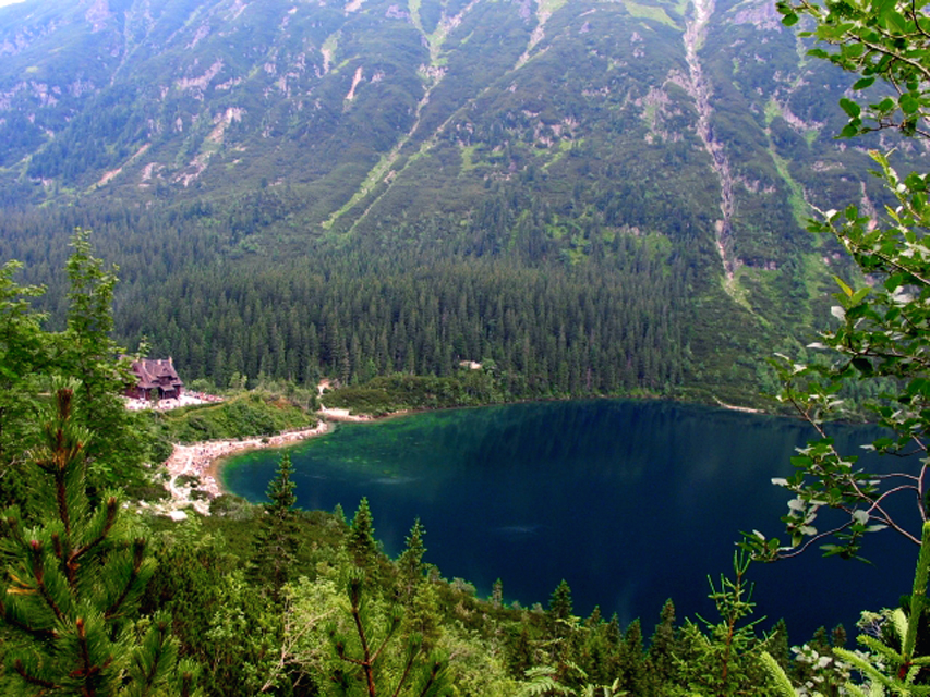
Il est situé sur le versant polonais du massif, à une altitude de 1 395,4 m. Sa surface est de 34,93 ha et sa profondeur de 50,8 m. Son volume d'eau est de 9 935 000 m3 pour une longueur de 862 m et une largeur de 566 m.
Voir aussi
Notes et références
 Portail de la Pologne
  Portail des lacs et cours d'eau
  Portail des Carpates
На других языках
[de] Meerauge
Das Meerauge (pl. Morskie Oko, slk. Morské oko, deutsch auch: Fischsee) in Polen ist der flächenmäßig größte und der vierttiefste Bergsee der Hohen Tatra am Fuße des Massivs der Mięguszowieckie Szczyty im Tal Dolina Rybiego Potoku. Im Jahr 2014 hat das The Wall Street Journal das Meerauge zu einem der fünf schönsten Seen weltweit gekürt.[1][en] Morskie Oko
Morskie Oko, or Eye of the Sea in English, is the largest and fourth-deepest lake in the Tatra Mountains, in southern Poland. It is located deep within the Tatra National Park in the Rybi Potok (the Fish Brook) Valley, of the High Tatras mountain range at the base of the Mięguszowiecki Summits, in Lesser Poland Voivodeship.- [fr] Morskie Oko
[it] Morskie Oko
Il Morskie Oko è un lago della Polonia situato negli Alti Tatra, nel Voivodato della Piccola Polonia.[ru] Морске-Око (озеро, Польша)
Морске-Око (польск. Morskie Oko) — озеро в Татровском повяте Малопольского воеводства Польши. Это крупнейшее и четвёртое по глубине озеро в Татрах. Оно расположено в Татранском национальном парке, в долине Рыбий Поток хребта Высокие Татры у подножья Менгушовецких вершин.Текст в блоке "Читать" взят с сайта "Википедия" и доступен по лицензии Creative Commons Attribution-ShareAlike; в отдельных случаях могут действовать дополнительные условия.
Другой контент может иметь иную лицензию. Перед использованием материалов сайта WikiSort.org внимательно изучите правила лицензирования конкретных элементов наполнения сайта.
Другой контент может иметь иную лицензию. Перед использованием материалов сайта WikiSort.org внимательно изучите правила лицензирования конкретных элементов наполнения сайта.
2019-2025
WikiSort.org - проект по пересортировке и дополнению контента Википедии
WikiSort.org - проект по пересортировке и дополнению контента Википедии