geo.wikisort.org - Réservoir
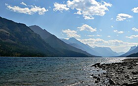
Le lac Waterton Supérieur (anglais : Upper Waterton Lake) est un lac situé sur la frontière canado-américaine dans les parcs nationaux des Lacs-Waterton et de Glacier. Il est le plus haut d'une série de trois lacs et a été nommé en l'honneur de Charles Waterton (1782-1865), naturaliste et explorateur britannique, lors de l'expédition Palliser[2].
| Lac Waterton Supérieur | |
 Lac Waterton Supérieur vu en direction des États-Unis | |
| Administration | |
|---|---|
| Pays | |
| État et province | |
| Géographie | |
| Coordonnées | 49° 01′ 41″ N, 113° 54′ 19″ O[1] |
| Superficie | 11,6 km2 |
| Altitude | 1 280 m |
| Profondeur · Maximale · Moyenne |
150 m 80 m |
| Hydrographie | |
| Alimentation | Rivière Waterton |
| Émissaire(s) | Rivière Waterton |
| modifier |
|
Notes et références
- « Upper Waterton Lake », sur Service de recherche de toponymes (consulté le )
- « Coup d'œil sur l'histoire de Waterton », sur Parcs Canada (consulté le )
Liens externes
- Ressources relatives à la géographie :
- Portail des lacs et cours d'eau
- Portail de l’Alberta
- Portail du Montana
На других языках
[en] Waterton Lake
Waterton Lake is a mountain lake in southern Alberta, Canada and northern Montana, United States. The lake is composed of two bodies of water, connected by a shallow channel known locally as the Bosporus.[1] The two parts are referred to as Middle Waterton Lake, and Upper Waterton Lake, the latter of which is divided by the Canada–United States border with Canada containing about two thirds of the lake while the Southern third falls in the United States.[1] The Boundary Commission Trail ends at the lake as the last border marker was placed there on 8 August 1874.[2] The United States Geological Survey gives the geocoordinates of 49°03′00″N 113°54′03″W for Upper Waterton Lake. Lower Waterton Lake is north of Middle Waterton Lake and is separated by a channel known as the Dardanelles.[1]- [fr] Lac Waterton Supérieur
[ru] Уотертон
Уо́тертон[4][5] или Аппер-Уотертон[6] (англ. Upper Waterton Lake[2][7], Waterton Lake[2], Chief Mountain Lake[8], Kootenai Lake[8]) — крупнейшее озеро одноимённой озёрной группы — Уотертон[9][4], находится на границе Канады и США, в природоохранном округе № 4 Уотертон на юге провинции Альберта (Канада) и округе Гласье на севере штата Монтана (США)[2][7][8].Текст в блоке "Читать" взят с сайта "Википедия" и доступен по лицензии Creative Commons Attribution-ShareAlike; в отдельных случаях могут действовать дополнительные условия.
Другой контент может иметь иную лицензию. Перед использованием материалов сайта WikiSort.org внимательно изучите правила лицензирования конкретных элементов наполнения сайта.
Другой контент может иметь иную лицензию. Перед использованием материалов сайта WikiSort.org внимательно изучите правила лицензирования конкретных элементов наполнения сайта.
2019-2025
WikiSort.org - проект по пересортировке и дополнению контента Википедии
WikiSort.org - проект по пересортировке и дополнению контента Википедии


