geo.wikisort.org - Réservoir
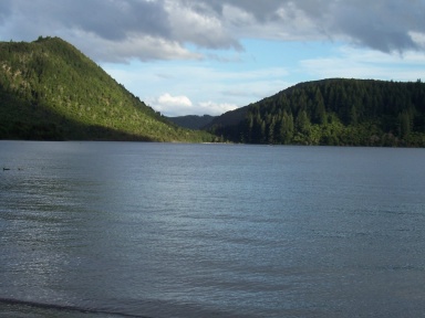
Le lac Tikitapu (« Blue Lake » en anglais) est un lac situé à Rotorua, sur l'Île du Nord de la Nouvelle-Zélande.
Cet article est une ébauche concernant un lac et la géographie de la Nouvelle-Zélande.
Vous pouvez partager vos connaissances en l’améliorant (comment ?) selon les recommandations des projets correspondants.
| Lac Tikitapu | ||
| ||
| Administration | ||
|---|---|---|
| Pays | ||
| Subdivision | Baie de l'Abondance | |
| Géographie | ||
| Coordonnées | 38° 12′ S, 176° 20′ E | |
| Superficie | 1,46 km2 |
|
| Longueur | 1,6 km | |
| Largeur | 1,3 km | |
| Altitude | 418 m | |
| Profondeur · Maximale · Moyenne |
27,5 m 19,1 m |
|
| Géolocalisation sur la carte : Nouvelle-Zélande
| ||
| modifier |
||

Voir aussi
Articles connexes
Notes et références
 Portail des lacs et cours d'eau
  Portail de la Nouvelle-Zélande
На других языках
[de] Tikitapu/Blue Lake
Der Tikitapu/Blue Lake ist ein Kratersee im Rotorua District der Region Bay of Plenty auf der Nordinsel von Neuseeland.[en] Lake Tikitapu
Lake Tikitapu, more commonly known as Blue Lake, is the smallest of four small lakes lying between Lake Rotorua and Lake Tarawera in the Bay of Plenty region of New Zealand's North Island. The other three are Lake Rotokakahi (Green Lake), Lake Okareka, and Lake Okataina.- [fr] Lac Tikitapu
[it] Lago Tikitapu
Il lago Tikitapu o lago blu (Blue Lake), è uno della serie di laghi che giacciono fra il lago Rotorua ed il lago Tarawera nella regione di Bay of Plenty nell'Isola del Nord della Nuova Zelanda. Gli altri laghi del gruppo sono il lago Okataina, lago Rotokakahi ed il lago Okareka; tutti fanno parte del bordo ovest della caldera di Okataina.Текст в блоке "Читать" взят с сайта "Википедия" и доступен по лицензии Creative Commons Attribution-ShareAlike; в отдельных случаях могут действовать дополнительные условия.
Другой контент может иметь иную лицензию. Перед использованием материалов сайта WikiSort.org внимательно изучите правила лицензирования конкретных элементов наполнения сайта.
Другой контент может иметь иную лицензию. Перед использованием материалов сайта WikiSort.org внимательно изучите правила лицензирования конкретных элементов наполнения сайта.
2019-2026
WikiSort.org - проект по пересортировке и дополнению контента Википедии
WikiSort.org - проект по пересортировке и дополнению контента Википедии