geo.wikisort.org - Reservoir
Yanawayin (Quechua yana black, Ancash Quechua wayi house, "black house",[1][2] -n a suffix, other spellings Yanahuain, Yanahuin, Yanahuni, Yanahuani) is a lake in the central Peruvian Andes. It lies in the Lima Region, Huaral Province, Andamarca District, near the village of Yanawayin (Yanahuain).[3][4] The lake is situated at an altitude of about 4,370 m (14,340 ft).

| Yanawayin Lake | |
|---|---|
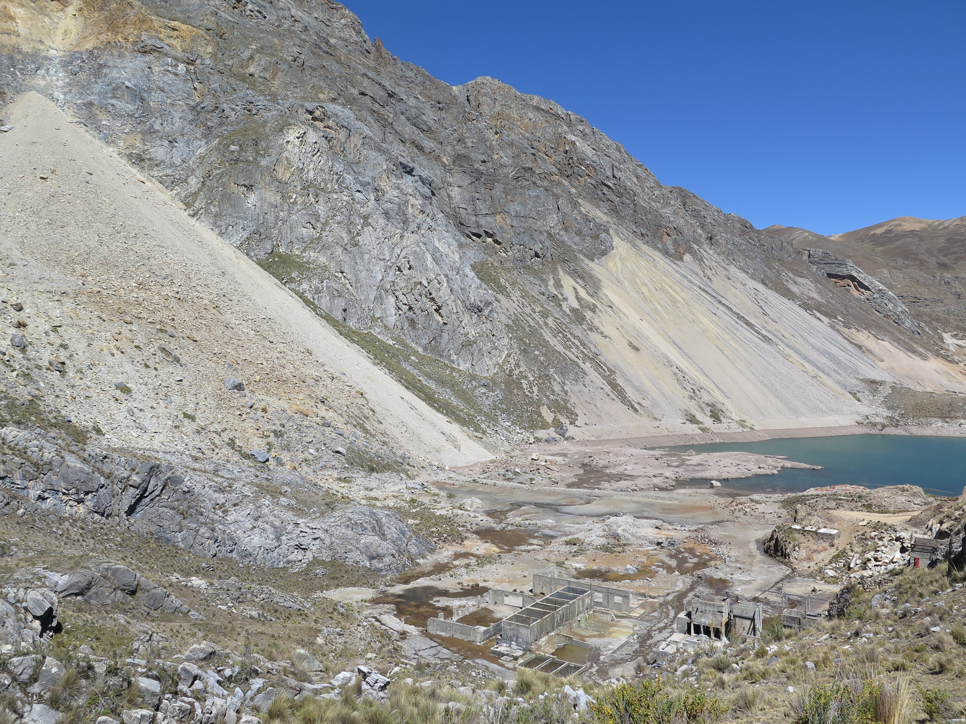 Partial view of Yanawayin Lake. Remainings of the Chungar Mine camp. Picture looking SW | |
 Yanawayin Lake | |
| Location | Lima Region |
| Coordinates | 11°07′36″S 76°32′7″W |
| Basin countries | Peru |
| Surface elevation | 4,370 m (14,340 ft) |
Landslide
The site made world headlines in 1971 when on March 18 a rock avalanche of 100,000 cubic metres (3,500,000 cu ft)[5] fell from an outcrop of jointed limestone about 400 metres (1,300 ft) above the lake. It created a wave of 30 metres (98 ft) that destroyed the Chungar Mine camp on the shore, owned by the Mining Company (Cia Minera Chungar, S.A.), destroyed all the mines' surface facilities,[5] and killed 200–600 miners.[3][5][6]
See also
References
- Teofilo Laime Ajacop. Diccionario Bilingüe Iskay Simipi Yuyayk'ancha, La Paz, 2007 (Quechua-Spanish dictionary)
- Robert Beér, Armando Muyolemaj, Dr. Hernán S. Aguilarpaj. Vocabulario Comparativo Quechua Ecuatoriano - Quechua Ancashino, Castellano - English, Brighton. October 2006. (in Spanish)
- Petley, Dave (March 18, 2009). "38 years ago today – the Chungar landslide in Peru". American Geophysical Union (AGU). Retrieved April 18, 2014.
- escale.minedu.gob.pe - UGEL map of the Huaral Province (Lima Region) showing the lake (unnamed) near the village of Yanawayin (Yanahuain) and near the destroyed village of Chungar
- Robert B. Jansen, ed. (1988). Advanced Dam Engineering for Design, Construction, and Rehabilitation. Springer. p. 739. ISBN 978-0-442-24397-5. Retrieved 4 May 2014.
- Plafker, George; Eyzaguirre, V. Z. (1 January 1979). "7: Rock Avalanche and Wave at Chungar, Peru". In Barry Voight (ed.). Engineering Sites: Rockslides and Avalanches (1 ed.). Elsevier. pp. 269–279. ISBN 0-444-59801-4. Retrieved 4 May 2014.
This Lima Region geography article is a stub. You can help Wikipedia by expanding it. |
На других языках
[de] Lago Yanawayin
Lago Yanawayin (oder Yanahuni, Yanahuin oder Yanahuani, auch: Laguna Pampa) ist ein 4354 m hoch gelegener etwa acht Hektar großer Bergsee in der peruanischen Westkordillere. Der See befindet sich im Distrikt Santa Cruz de Andamarca der Provinz Huaral in der Region Lima. Der Name des Sees setzt sich zusammen aus yana (schwarz) und wayi (Haus/Bau) in Quechua.- [en] Yanawayin Lake
[fr] Lac Yanawayin
Yanawayin est un lac de la cordillère des Andes péruviennes centrales. Il se trouve dans la région de Lima, province de Huaral, district d'Andamarca, près du village de Yanawayin (Yanahuain)[1],[2].Другой контент может иметь иную лицензию. Перед использованием материалов сайта WikiSort.org внимательно изучите правила лицензирования конкретных элементов наполнения сайта.
WikiSort.org - проект по пересортировке и дополнению контента Википедии