geo.wikisort.org - Reservoir
Wielki Staw (1,225 metres (4,019 ft), Polish for The Big Pond, Grosser Teich in German) - post glacial natural lake in the Krkonoše mountains, in western Poland. It is situated in the Karkonosze National Park at the bottom of the cirque, on the southern slope of the Smogornia mountain.[1]
| Wielki Staw | |
|---|---|
 | |
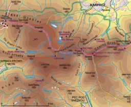 Wielki Staw Location of Wielki Staw within the Central Krkonoše | |
| Location | Poland |
| Coordinates | 50°45′30″N 15°41′37″E |
| Surface area | 8.3 ha (21 acres) |
| Surface elevation | 1,225 m (4,019 ft) |
With its area of 8.3 hectares,[2] it is the biggest glacial lake in the whole range. Its depth reaches 25 m, the shores are covered in subalpine species. Waters of the lake host rare species, some of them even extinct like Isoetes lacustris.[3] Due to the regulations of a nature reserve, the object is closed and can be watched only from the top of the cirque. The place is accessible from the Polish–Czech Friendship Trail (red marks).
References
- "Kotły Małego i Wielkiego Stawu". Retrieved 2010-01-02.
- "Kocioł Wielkiego Stawu". Retrieved 2010-01-02.
- "Flora i fauna Karkonoszy - Wielki Staw". Retrieved 2010-01-02.
See also
This Poland location article is a stub. You can help Wikipedia by expanding it. |
На других языках
[de] Wielki Staw
Der Wielki Staw (Großer Teich) ist der größere von zwei Karseen auf polnischer Seite des Smogornia (Mittagsberg, tschech. Stříbrný hřbet). Mit einer Fläche von 8,3 Hektar und einer Tiefe von 24,4 Metern ist er der größte See glazialen Ursprungs im Riesengebirge.- [en] Wielki Staw
Другой контент может иметь иную лицензию. Перед использованием материалов сайта WikiSort.org внимательно изучите правила лицензирования конкретных элементов наполнения сайта.
WikiSort.org - проект по пересортировке и дополнению контента Википедии