geo.wikisort.org - Reservoir
Tuanjie Lake is a lake in the southeastern Qarhan Playa north of Golmud in the Haixi Prefecture of Qinghai Province in northwestern China. It is fed from the south by the Shougong River. Like the other lakes of the surrounding Qaidam Basin, it is extremely saline.
| Tuanjie Lake | |
|---|---|
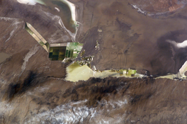 Tuanjie Lake in 2003, surrounded with salt pans. The town of Qarhan and Lake Dabusun are visible to the NW. | |
 Tuanjie Lake | |
| Location | Golmud County Haixi Prefecture Qinghai Province China |
| Coordinates | 36°43′50″N 95°21′42.5″E |
| Type | Endorheic saline lake |
| Native name | 团结湖 (Chinese) |
| Primary inflows | Shougong River |
| Basin countries | China |
| Surface area | 6 km2 (2.3 sq mi) |
| Surface elevation | 2,675 m (8,776 ft) |
| Tuanjie Lake | |||||||||
|---|---|---|---|---|---|---|---|---|---|
 The Sanhu Depression in 2014, with Tuanjie in the extreme SE (ESA) | |||||||||
| Traditional Chinese | 團結湖 | ||||||||
| Simplified Chinese | 团结湖 | ||||||||
| Literal meaning | Solidarity Lake Unity Lake | ||||||||
| |||||||||
Geography

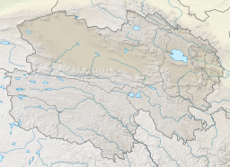
Tuanjie Lake at the southern edge of the Qaidam subbasin[1] in the eastern Qarhan Playa at an elevation of 2,675 m (8,776 ft) above sea level.[2] It has an area of 6 km2 (2.3 sq mi).[2] It lies southeast of Dabusun Lake, south of Xiezuo Lake, and west of South Hulsan Lake[1] and is fed by the intermittent stream of the Shougong River (收工河, Shōugōng Hé).[3] Its depth usually does not exceed 1 m (3 ft 3 in).[4]
Tuanjie's position at the south end of the playa means that its waters are relatively less influenced by the concentrated mineral springs along the playa's northern boundary.[5] Nonetheless, the lake's brine is at or near saturation with calcite, halite, polyhalite, kieserite, and (importantly) carnallite,[6] which is processed to produce potash for potassium-rich fertilizers and other uses.
See also
- Qarhan Playa & Qaidam Basin
- List of lakes and saltwater lakes of China
References
Citations
- Du & al. (2018), pp. 2–3.
- Zheng (1997), p. 16
- Yu & al. (2009), p. 2.
- Yu & al. (2001), p. 62.
- Spencer & al. (1990), pp. 398–399.
- Spencer & al. (1990), p. 404.
Bibliography
- Du Yongsheng; et al. (April 2018), "Evalutation of Boron Isotopes in Halite as an Indicator of the Salinity of Qarhan Paleolake Water in the Eastern Qaidam Basin, Western China", Geoscience Frontiers, Beijing: China University of Geosciences, 10 (1): 1–10, doi:10.1016/j.gsf.2018.02.016.
- Spencer, Ronald James; et al. (1990), "Origin of Potash Salts and Brines in the Qaidam Basin, China" (PDF), Fluid-Mineral Interactions: A Tribute to H.P. Eugster, Special Publication No. 2, Geochemical Society.
- Yu Ge; et al. (2001), Lake Status Records from China: Data Base Documentation (PDF), MPI-BGC Tech Rep, No. 4, Jena: Max Planck Institute for Biogeochemistry.
- Yu Shengsong; et al. (2009), Chá'ěrhán Yánhé Zīyuán: Kěchíxù Lìyòng Yánjiū 察尔汗盐河资源: 可持续利用研究 [Qarhan Playa Resources: A Study of Sustainable Use] (PDF) (in Chinese), Beijing: Kexue Chubanshe.
- Zheng Mianping (1997), An Introduction to Saline Lakes on the Qinghai–Tibet Plateau, Dordrecht: Kluwer Academic Publishers, ISBN 9789401154581.
Другой контент может иметь иную лицензию. Перед использованием материалов сайта WikiSort.org внимательно изучите правила лицензирования конкретных элементов наполнения сайта.
WikiSort.org - проект по пересортировке и дополнению контента Википедии