geo.wikisort.org - Reservoir
The Titisee is a lake in the southern Black Forest in Baden-Württemberg. It covers an area of 1.3 km2 (320 acres) and is an average of 20 m (66 ft) deep.[1] It owes its formation to the Feldberg glacier, the moraines of which were formed in the Pleistocene epoch and nowadays form the shores of the lake. The lake's outflow, at 840 m (2,760 ft) above sea level, is the River Gutach, which merges with the Haslach stream below Kappel to form the Wutach. The waters of the Titisee thus drain eventually into the Upper Rhine between Tiengen and Waldshut. On the north shore lies the spa town of the same name, today a part of the municipality of Titisee-Neustadt.[1]
| Titisee | |
|---|---|
 View from the Hochfirst | |
 Titisee | |
| Location | South Black Forest |
| Coordinates | 47°54′N 8°09′E |
| Primary inflows | Seebach |
| Primary outflows | Gutach |
| Catchment area | 24.2 km2 (9.3 sq mi)[1] |
| Basin countries | Germany |
| Max. length | 1.87 km (1.16 mi)[1] |
| Max. width | 750 m (2,460 ft)[1] |
| Surface area | 1.07 km2 (0.41 sq mi)[1] |
| Average depth | 20.5 m (67 ft)[1] |
| Max. depth | 39.0 m (128.0 ft)[1] |
| Water volume | 22,500,000 m3 (790,000,000 cu ft)[1] |
| Surface elevation | 845 m (2,772 ft) |
| Settlements | Titisee-Neustadt |
History
A glacial lake is created when the glacier remains stationary for a long time and the weight of the glacier excavates the landscape. Where the glacier is less powerful, the subsoil is less excavated and rises. In addition, it is possible that a moraine (deposit of rock material that is transported with the glacier) prevents the runoff. When the ice melts, water is dammed up to the moraine and a lake is created.[2] The Titisee owes its formation to the last ice age (Pleistocene). Up until 10,000 years ago, a glacier stretched from the Feldberg to what is now Lake Titisee. The basin carved out by the glacier and the terminal moraine form the Titisee today.[3]
The first records of the lake date to 1050 and the abbey of Allerheiligen in Schaffhausen, where the name Titinsee is mentioned. The name Dettesee is also mentioned in a deed from the parish of Saig that dates to 1111. The name of the lake adopted its present from around 1750.[4]
In the valleys around the Titisee (Altenweg, Spriegelsbach, Schildwende and Jostal), people usually worked in the agricultural sector, breeding cattle. Craftsmen like blacksmiths, wagon makers and shingle makers would work nearer to the lake. For a long time, there have been scattered farms around the lake. At the beginning of the 20th century, the construction of the Höllentalbahn and the onset of tourism led to a central village emerging at the lake.[4]
In 1840, two sarcophagi made of worked tuff were found below a knoll by the outflow of the Gutach from the Titisee. In 2011, the archaeologist, Andreas Haasis-Berner, published an article stating that they had to date to the period between 700 and 900. Hitherto, it had been thought that the High Black Forest had been unsettled during the first millennium.[5][6]
Origin of the name
There are various theories about the origin of the unusual name Titisee:
- In the Alemannic dialect Teti means "little child" or "baby". Tetisee or Titisee would then be a lake from which, according to local legend, small children came, similar to the story told in other places that babies are delivered by a white stork. Stories about babies coming from lakes were widespread in Central Europe (c.f. Frau-Holle-Teich). Consistent with this theory, is the fact that the Titisee is a very high altitude lake and that, also according to legend, it is bottomless. Such lakes were formerly attributed with special numinous powers.[7]
- According to another theory, the Roman general, Titus, was supposed to have camped in the area of the Titisee. The lake was said to have impressed him so much that he gave his name to it. This is also the reason why, today, a crude replica of a Roman galley plies the Titisee.[8]
- According to a legend a nobleman called Titini hunted in the area around the lake in the 12th century.
- Also the arum lily, formerly known in the region as the Tittele, could be the origin of the name, even though it no longer occurs by the Titisee.
Tourism
At the north shore of the Titisee lies a popular spa town of the same name. Lots of wellness and health hotels are settled there. Spa therapy offers include Fango applications (mudpack applications with hot, odorless mineral mud[9]), healing climate, Kneipp facilities, moor[10] as well as breathing aerobics, movement therapy in thermal mineral water, relaxation therapy, terrain spa trails, physiotherapy, and medical and wellness massages.[10]
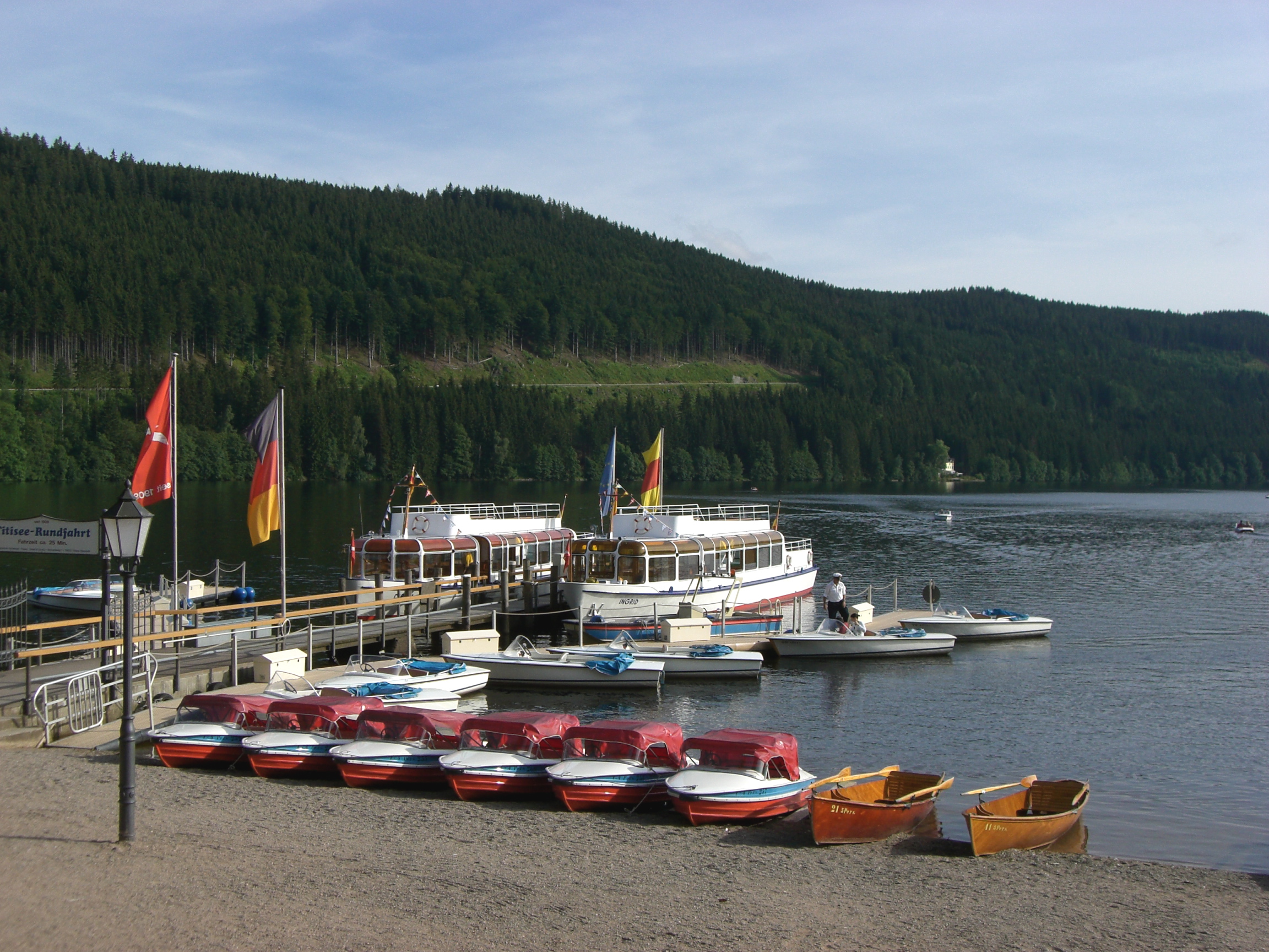
In the summer, the lake invites tourists to swim, sail, windsurf, hire pedaloes, hike around the lake, and stroll along the promenade. Furthermore, plenty of open-air events are organised around the lake each summer.[11]
In winter, the 1.2 km long Saig-Titisee toboggan is open. The largest natural ski jump in Germany, the Hochfirstschanze, is also located at the Titisee.[12] The ski jump is host to various ski jumping events like the 2020–21 FIS Ski Jumping World Cup.[13]
Winter freezing
The Titisee takes a long time to freeze over in the winter owing to the winds, which keep the surface of the water moving almost all continuously. For the frozen lake to be opened for use, it must have a solid ice thickness of at least 16 cm (6.3 in) (solid ice or compacted ice has virtually no air pockets). When conditions appear favourable for the opening the lake, daily ice measurements are taken by the Titisee-Neustadt municipal authorities at three or four places. If opening the ice to public use is possible, and those responsible give it their blessing, specific, demarcated areas of the lake are opened, but never the whole lake.
These regulations were put in place after an accident in 1966. Up to that time, the lake had been used in winter as a landing strip for small aircraft. On 14 January 1966, a tractor with a snowplough was clearing the landing strip of snow when it broke through the ice and sank to the bottom of the lake, taking the driver, Walter Wilde (29), with it. His body was only recovered 2 weeks later.[14]

Fauna and flora

In the nutrient-poor Titisee there are large predatory fish (pike-perch, sea trout and a large stock of pike), schooling fish (whitefish, roach and perch) as well as carp, chub and tench in shallower areas. This variety of species is joined by brown trout, char and rainbow trout where the streams enter the lake, and by eels and burbot on the lake bed. In addition there are small fish varieties such as sunbleak, minnow and brook lamprey. Around the lake, grey heron may be seen.
The shores of the Titisee are home to two rare types of quillworts, the spring quillwort and the lake quillwort.[15]
Photo gallery
 Map of Titisee
 View over Titisee from the south (postcard, about 1909)
 North shore with boat rental
 Pier for a touring boat that circles the lake. Winter scene


References
- Documentation on the Condition and Development of the Most Important Lakes in Germany: Part 10, Baden-Württemberg (pdf; 411 KB)
- "Naturpark Südschwarzwald - Geologie". www.naturpark-suedschwarzwald.de. Retrieved 2020-11-02.
- "Der Titisee im Schwarzwald". www.schwarzwald.com. Retrieved 2020-11-02.
- "Titisee-Neustadt". www.alemannische-seiten.de (in German). Retrieved 2020-11-02.
- Andreas Haasis-Berner: Das Rätsel vom Titisee, In: Archäologische Nachrichten aus Baden, Heft 80/81
- Peter Stellmach: Titisee-Neustadt: Die Stadt hätte ums Haar das 900. Jubiläum verpasst: Schnell, schnell, Titisee feiert doch Geburtstag!, Badische Zeitung, 25 February 2011, retrieved 23 June 2011
- Artikel Kinderherkunft, Handwörterbuch des deutschen Aberglaubens, Berlin, 2006, Digitale Bibliothek 145, Directmedia, p. 1350.
- "Titisee im Schwarzwald". www.schwarzwaldportal.com. Retrieved 2020-11-02.
- "Fango - leicht erklärt im Wellness-Lexikon von wellness.info". www.wellness.info. Retrieved 2020-11-02.
- "Titisee-Neustadt". www.schwarzwald-tourismus.info (in German). Retrieved 2020-11-02.
- "Schiff ahoi!". Hochschwarzwald Tourismus GmbH (in German). Retrieved 2020-11-02.
- "Sehenswürdigkeiten und Ausflugsziele in Titisee". Hochschwarzwald Tourismus GmbH (in German). Retrieved 2020-11-02.
- "weltcupskispringen.com – Weltcup in Titisee-Neustadt | Hochschwarzwald. Hochgefühl" (in German). Retrieved 2020-11-02.
- Hans Schmider (2004), Titisee-Chronik – Die Geschichte des Titisees und seiner Anwohner (in German), Titisee-Neustadt: Selbstverlag Hans Schmider
- Richard Pott (1996), Biotoptypen : Schützenswerte Lebensräume Deutschlands und angrenzender Regionen (in German), Stuttgart (Hohenheim): Ulmer, p. 55, ISBN 978-3-8001-3484-7
Other sources
- Nixdorf, B.; et al. (2004), "Titisee", Dokumentation von Zustand und Entwicklung der wichtigsten Seen Deutschlands (in German), Berlin: Umweltbundesamt, p. 29
External links
| Wikimedia Commons has media related to Titisee. |
- Official website of the municipality Titisee-Neustadt
- Touristic information about the Titisee
- Webcam Weiherhof of the Titisee
Authority control | |
|---|---|
| General |
|
| National libraries | |
На других языках
[de] Titisee
Der Titisee ist ein See im südlichen Schwarzwald in Baden-Württemberg. Er bedeckt eine Fläche von 1,07 km2 und ist durchschnittlich 20 m tief. Seine Entstehung verdankt er dem Feldberg-Gletscher, dessen im Pleistozän entstandene Moränen heute seine Ufer bilden. Gespeist wird er von dem das Bärental durchfließenden Seebach, der am Seebuck, am Osthang des Feldberg-Massivs, dem Feldsee entspringt. Der Ausfluss des Sees auf 840 m ü. NHN ist die Gutach, die ab dem Zusammenfluss mit der Haslach unterhalb von Kappel den Namen Wutach trägt. Damit entwässert der Titisee schließlich zusammen mit der Wutach zwischen Tiengen und Waldshut in den Hochrhein. Am Nordufer liegt der gleichnamige Kurort, der Teil der Stadt Titisee-Neustadt ist. Der südwestliche Teil liegt auf Hinterzartener Gemarkung. Die Wasserqualität des Titisees wird an zwei Badestellen[2][3] regelmäßig von der Landesanstalt für Umwelt Baden-Württemberg kontrolliert.- [en] Titisee
[es] Titisee
El Titisee (en alemán: Titisee) es un lago ubicado en el sur de la Selva Negra Alemana (Schwarzwald) en el estado Federado de Baden-Württemberg. Cubre una superficie de cerca de 1,3 km² y en promedio tiene una profundidad de 20 metros. Su origen radica en los glaciares de la cordillera del Feldberg, los cuales en el Pleistoceno formaron las riberas actuales. El desagüe del lago queda a 840 metros sobre el nivel del mar y es el arroyo Gutach; en la ribera norte donde queda la población que lleva el mismo nombre y que es una parte de la ciudad Titisee-Neustadt.[fr] Titisee
Le Titisee est un lac de la Forêt-Noire dans le land de Bade-Wurtemberg. D'origine glaciaire, il s'est constitué derrière une moraine remontant à la glaciation de Würm. Ses caractéristiques et ses dimensions en font le parfait symétrique du lac de Gérardmer côté français.[it] Titisee
Titisee è un lago della Germania (Baden-Württemberg), situato nella Foresta Nera, a SE di Friburgo in Brisgovia. Il lago si trova a 845 m sul livello del mare e la sua superficie misura circa 1,2 km². La profondità media è di circa 20 m e quella massima di 40 m. Sulla sponda nordorientale è situato il centro turistico di Titisee.[ru] Титизе
Титизе (нем. Titisee) — озеро в южном Шварцвальде в германской федеральной земле Баден-Вюртемберг. Его площадь составляет 1,3 км², а средняя глубина — 20 м. Возникло в плейстоцене благодаря леднику с соседней вершины Фельдберг, наивысшей точки Шварцвальда. Озеро находится на высоте 840 м над уровнем моря. На северном берегу расположен курортный город Титизе-Нойштадт. К югу от Титизе расположены менее туристически освоенные озёра Шлухзе и Виндгфельвайер.Другой контент может иметь иную лицензию. Перед использованием материалов сайта WikiSort.org внимательно изучите правила лицензирования конкретных элементов наполнения сайта.
WikiSort.org - проект по пересортировке и дополнению контента Википедии