geo.wikisort.org - Reservoir
Leitisvatn is the largest lake in the Faroe Islands. It is situated on the island of Vágar between the municipalities of Sørvágur and Vágar. Its area is 3.4 km2, more than three times the size of Fjallavatn, the second largest lake, also located on Vágar.
| Leitisvatn | |
|---|---|
 Leitisvatn seen from Trælanípan, Vágar. | |
 Leitisvatn | |
| Location | Vágar |
| Coordinates | 62°03′N 7°14′W |
| Catchment area | 35.2 km2 (13.6 sq mi) |
| Basin countries | (Faroe Islands) |
| Surface area | 3.4 km2 (1.3 sq mi) |
| Average depth | 27.5 m (90 ft) |
| Max. depth | 59 m (194 ft) |
| Surface elevation | 32 m (105 ft) |
Name
Among the locals, there is disagreement regarding the name of the lake. The inhabitants of Sørvágur to the west prefer Sørvágsvatn, which means "the lake by Sørvágur". The inhabitants of Miðvágur and Sandavágur to the east prefer Leitisvatn, which means "the lake by Leiti", referring to the territory on the east side of it.
The village of Miðvágur is situated closer to the lake than Sørvágur, but the latter is considered to have been settled earlier. Sørvágur – alongside Bøur and Sandavágur – is considered one of the three original settlements on Vágar. These divided the land on the island into three equal regions of 60 marks, which would place the lake within Sørvágur's region.
The locals mostly refer to it as Vatnið ("the lake"), which is understood as a reference to that body of water. It is mostly when people from other parts of the Faroes refer to the lake by one of its given names that the debate will occur.
Geography
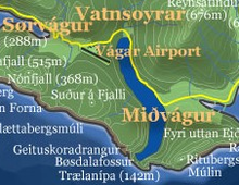

The lake is located very close to the ocean, but its surface is about 40 meters above the level of the sea. It is surrounded by a higher cliff which prevents it from emptying fully into the ocean, the waterfall Bøsdalafossur being the outlet. The greater height of the cliffs on either side of Bøsdalafossur can give the illusion from certain perspectives that the lake is higher above sea level than it is.[1]
History
During World War II, the British army built an airfield (now Vágar Airport) to the west of the lake. They also built a station to support seaplanes. The first aircraft to land on the lake was a Catalina from RAF Coastal Command, in 1941.[2]
Places and names
- Trælanípan
- Oyrar
- Bøsdalafossur
- Sjatlá
- Sálarbótsá
Tourism
There are opportunities for fishing brown trout on the lake. In the summer of 2005 a local initiative was set up for boat excursions on it.[3]
References
- Strutner, Suzy. "An Optical Illusion Makes Lake Sørvágsvatn Look Absolutely Trippy". Huffington Post. Retrieved 30 May 2016.
- A Wireless Operator in the Faroe Islands, BBC
- "Welcome to LAKESIDE SIGHTSEEING!". www.lakeside.fo. Archived from the original on 18 October 2005. Retrieved 22 May 2022.
На других языках
[de] Sørvágsvatn
Das Sørvágsvatn bzw. Leitisvatn ist mit 3,56 km² der größte Binnensee der Färöer und liegt im Süden der Insel Vágar.- [en] Sørvágsvatn
[fr] Sørvágsvatn
Sørvágsvatn (également appelé Leitisvatn) est le plus grand lac des Îles Féroé. Il est situé sur l'île de Vágar, entre la commune de Sørvágs et la commune de Vága. Sa superficie est de 3,4 km2, soit plus de trois fois celle de Fjallavatn, le second plus grand lac de l'archipel, également situé sur Vágar.[it] Sørvágsvatn
Sørvágsvatn è un lago situato nella parte settentrionale dell'isola di Vágar, parte delle Isole Fær Øer, con una superficie di 3,4 km². È il lago più grande dell'arcipelago[1][2].[ru] Сёрвогсватн
Сёрвогсватн или Лайтисватн (фар. Sørvágsvatn / Leitisvatn) — наибольшее по площади и глубине озеро Фарерских островов, расположенное на острове Воар. Среди путешественников получило неофициальное название «озеро над океаном» из-за значительного перепада высот между зеркалом озера и уровнем океана. Вода из озера стекает в океан по крутым утёсам, образуя водопад Бёсдеалафоссур, который сложно увидеть, поскольку он скрыт посреди отвесных береговых скал. Площадь водосборного бассейна — 35,2 км²[1].Другой контент может иметь иную лицензию. Перед использованием материалов сайта WikiSort.org внимательно изучите правила лицензирования конкретных элементов наполнения сайта.
WikiSort.org - проект по пересортировке и дополнению контента Википедии