geo.wikisort.org - Reservoir
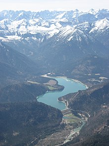
Sylvenstein Dam is an earthen embankment dam in the Isar valley, in the alpine part of Upper Bavaria, Germany which impounds the Sylvenstein Reservoir (German: Sylvensteinspeicher).
| Sylvenstein Dam | |
|---|---|
 | |
 Location of Sylvenstein Dam in Germany | |
| Country | Germany |
| Location | Bad Tölz-Wolfratshausen |
| Coordinates | 47°34′40″N 11°32′28″E |
| Construction began | 1954 |
| Opening date | 1959 |
| Dam and spillways | |
| Type of dam | Embankment dam |
| Height | 44 m (144 ft) |
| Length | 180 m (591 ft) |
| Dam volume | 1 hm3 (35,000,000 cu ft) |
| Reservoir | |
| Total capacity | 124 hm3 (4.4×10⁹ cu ft) |
| Catchment area | 1,100 km2 (420 sq mi) |
| Surface area | 6.6 km2 (2.5 sq mi) |
| Power Station | |
| Installed capacity | 7 MW |
In the 1920s, several hydropower plants were built in the tributary of the upper Isar river such as ones at the Achensee and Lake Walchen Power Plant. Therefore, the river ran nearly dry during the dry season, and the low water flow affected the town of Bad Tölz. A reservoir was established to ensure a minimum level of water in the river. During the dry season a volumetric flow of 4 cubic metres per second is released to prevent the Isar from running dry. Additionally, the reservoir provides flood control for Isar river between Bad Tölz and Munich.
The dam is 44 metres (144 ft) high and 180 metres (590 ft) long. It was built between 1954 and 1959. Since 1959, the water has also been used to operate a hydropower plant of 3.2 MW. The plant was upgraded in 2000 with new turbines to generate 3.8 MW.
During the 2005 European floods, the maximum capacity of the reservoir was reached. Consequently, excess water was released into the Isar river. Without the dam construction, the flooding in 2005 would have been even more severe than it actually was.

A small village named Fall was flooded in 1959. The Faller-Klamm-Brücke connects road traffic to the North (Bundesstraße 307).
External links
 Media related to Sylvensteinspeicher at Wikimedia Commons
- Information and photographs (in German)
На других языках
[de] Sylvensteinspeicher
Der Sylvensteinspeicher, auch Sylvensteinstausee oder schlicht Sylvensteinsee genannt, ist ein Stausee im Isarwinkel in der Gemeinde Lenggries, an der Straße von Bad Tölz zum Achensee (Bundesstraße 307), etwa 12 km südlich des Ortszentrums von Lenggries. Er wurde in den Jahren 1954 bis 1959 zum Hochwasserschutz im Isartal gebaut. In Trockenzeiten ist seit 1990 eine ausreichende Wasserführung der Isar gesichert, am Krüner Wehr wird aus ökologischen Gründen ein Restzufluss von mindestens 4 m³/s gewährleistet.- [en] Sylvenstein Dam
Другой контент может иметь иную лицензию. Перед использованием материалов сайта WikiSort.org внимательно изучите правила лицензирования конкретных элементов наполнения сайта.
WikiSort.org - проект по пересортировке и дополнению контента Википедии