geo.wikisort.org - Reservoir
Stanley Lake is an alpine lake in the western United States, located in Custer County, Idaho, at the base of the Sawtooth Mountains in the Sawtooth National Recreation Area.
| Stanley Lake | |
|---|---|
 McGowan Peak and Stanley Lake | |
 Stanley Lake  Stanley Lake | |
| Location | Custer County, Idaho |
| Coordinates | 44.244°N 115.059°W |
| Type | Glacial |
| Primary inflows | Stanley Lake Creek |
| Primary outflows | Stanley Lake Creek to Salmon River |
| Basin countries | United States |
| Max. length | 1 mile (1.6 km) |
| Max. width | 0.5 miles (0.8 km) |
| Surface elevation | 6,513 feet (1,985 m) |
The lake is approximately seven miles (11 km) west of Stanley, readily accessed via a three-mile (5 km) spur road from State Highway 21.[1] The surface elevation of the lake is 6,513 feet (1,985 m) above sea level.
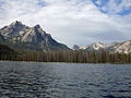
Stanley Lake is northeast of the base of the 9,860-foot (3,005 m) McGown Peak, and just south of the considerably smaller Elk Peak. The lake is two miles (3 km) downstream of Lady Face Falls on Stanley Lake Creek; it drains into the main Salmon River via Stanley Lake Creek and Valley Creek.
Recreational facilities at the lake include three campgrounds with nightly fees, a day use area, a boat launch, and hiking trails.
 Stanley Lake
 Mountains Behind Stanley Lake
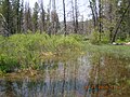 Wetlands Behind Stanley Lake


See also
- List of lakes of the Sawtooth Mountains (Idaho)
- Sawtooth National Forest
- Sawtooth National Recreation Area
- Sawtooth Range (Idaho)
References
- Sawtooth National Forest. “Sawtooth National Forest” [map].1:126,720, 1”=2 miles. Twin Falls, Idaho: Sawtooth National Forest, United States Forest Service, 1998.
External links
- Public Lands.org - Stanley Lake
- Fishing Works.com - Stanley Lake
- U.S. Forest Service - Sawtooth National Recreation Area
Другой контент может иметь иную лицензию. Перед использованием материалов сайта WikiSort.org внимательно изучите правила лицензирования конкретных элементов наполнения сайта.
WikiSort.org - проект по пересортировке и дополнению контента Википедии